Published on and written by Cyril Jarnias
Squeezed between the North Sea and the great states of Western Europe, the country of Belgium appears minuscule on a map. But this 30,689 km² territory packs an astonishing diversity of landscapes, local climates, natural environments, and forms of human settlement. From the windswept sandy coast to the forested high plateaus of the Ardennes, via the fertile plains of the center, Belgian geography explains much: its port power, its role as a European crossroads, but also its environmental and land-use challenges.
A Small Territory at the Heart of Europe
Located in the northwestern fringe of the continent, Belgium belongs to the historic group of the “Low Countries”, those low coastal lands open to the North Sea. It shares 1,385 km of land borders with France, the Netherlands, Germany, and Luxembourg, to which are added some 65 km of a straight coastline facing the North Sea. Most Western European capitals are within 1,000 km of Brussels, reinforcing its crossroads status, today materialized by the presence of European Union and NATO institutions.
Belgium’s total territory, including land, water bodies, and maritime space, amounts to just over 34,000 km².
Major Administrative and Physical Regions
The political organization partly reflects the geographical diversity. The federal country is based on three Regions: the Flemish Region in the north, rather low-lying and densely populated; the Walloon Region in the south, more hilly and largely rural; and the Brussels-Capital Region, a highly dense urban enclave. The distribution of area illustrates this contrast: Wallonia covers 16,901 km², or 55.1% of the territory, Flanders 13,626 km² (44.4%), and Brussels barely 162 km² (0.5%), yet home to over 1.2 million inhabitants.
Belgium is structured into three major geographical units from northwest to southeast: the coastal plain (Low Belgium, 200 m). The highest point in the country is the Signal de Botrange, at an elevation of 694 m.
Relief: From a Sea-Level Coast to the Summits of the Ardennes
Despite its discreet appearance, the Belgian relief is far from monotonous. It shifts within a few hundred kilometers from barely emerged coastal lands to an old Hercynian massif dissected by rivers.
The Coastal Plain and Polders
In the northwest, the coastal plain stretches for 65 km, from the Knokke-Heist area at the Dutch border to De Panne near France. It is rarely more than 10 to 20 km wide. It is a deceptively simple landscape: long beaches of fine sand, more or less fragmented dune belts, and a backcountry of absolutely flat polders, protected from the sea by a system of dikes.
The historic dune belt is now fragmented by seaside urbanization and infrastructure. The polders, lowlands reclaimed from the sea, illustrate a long-standing and profound human impact. This area is densely populated and urbanized, forming a continuum of ten coastal municipalities with a density of over 630 inhabitants/km², reinforced by strong seasonal tourist pressure.
The Central Plateau: A Fertile and Urbanized Heartland
Moving away from the sea, the plain gives way to the central plateau, a gently undulating surface that occupies most of the Flemish regions and central Wallonia. This plateau is cut by valleys, small vales, and local gorges, sometimes featuring karstic caves, as in the Famenne regions. The soils are generally fertile, especially in the loamy plateaus of Brabant, Hainaut, and Hesbaye, where large-scale cereal and sugar beet farming is concentrated.
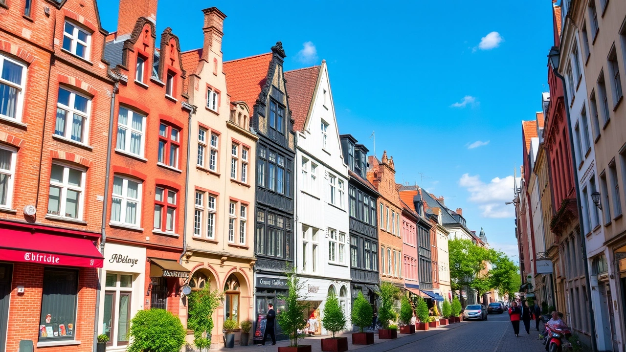
It is in this zone that the main settlement and communication axes developed. The major cities – Brussels, Antwerp, Ghent, Leuven, Mechelen – are largely situated in this “Middle Belgium” of low elevation, well-served by road, rail, and river networks.
The Ardennes and High Belgium: The Rugged Old Massif
The southeast of the country changes abruptly in character. The Ardennes form a vast, rugged plateau, forest-covered and cut by steep-sided valleys. Average elevations range between 300 and 500 m, but some areas easily exceed this threshold, notably in the High Fens. The highest point, the Signal de Botrange, peaks at 694 m. This summit, located in the municipality of Waimes (Liège province), is also the highest point of the entire Benelux.
The Ardennes relief originates from an ancient Hercynian massif, formed over 300 million years ago. This massif was folded, fractured, and then eroded, bringing to light ancient sedimentary rocks (schists, sandstones, quartzites, limestones) tilted into anticlines and synclines. The action of rivers subsequently sculpted this landscape, creating characteristic ridges, plateaus, and depressions like the Famenne or the Côtes Lorraines.
Further south, a small fringe is already part of the Paris Basin: this is Belgian Lorraine, an area of rounded hills extending French Lorraine.
Extreme Points: A Precise Grid
Belgian geography is sufficiently documented for its extreme points to be known very precisely. The north of the country touches the municipality of Hoogstraten (hamlet of Dreef), the south ends at Torgny, in the municipality of Rouvroy, already at the edge of Lorraine. To the west, it’s De Panne bordering France; to the east, the village of Krewinkel, in the municipality of Büllingen, constitutes the eastern extremity.
The Signal de Botrange, Belgium’s highest point, symbolically reaches this altitude thanks to an artificial tower.
A central point, calculated geometrically, is located at Nil-Saint-Vincent-Saint-Martin, in the municipality of Walhain, highlighting the relative compactness of a territory that does not exceed 280 km on its southeast-northwest diagonal and 222 km on its northeast-southwest diagonal.
Hydrography: A Country Turned Towards the North Sea
Almost the entire country of Belgium drains towards the North Sea. Only one exception: the municipality of Momignies, whose waters reach the English Channel via the Oise, a tributary of the Seine. Everywhere else, the hydrographic network converges on three major rivers on the Belgian scale: the Scheldt (Escaut), the Meuse (Maas), and the Yser (IJzer).
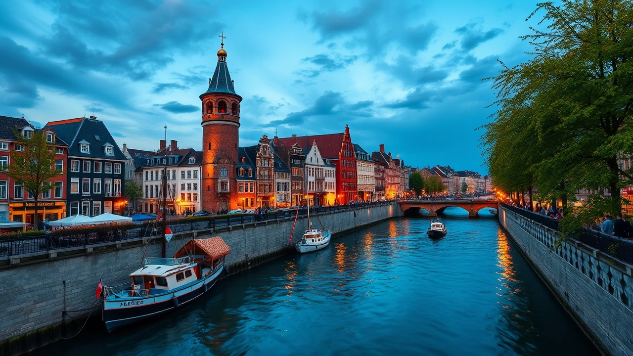
The Scheldt: Antwerp’s Waterway
The Scheldt (Schelde/Escaut) rises in France, crosses Wallonia then Flanders before flowing into the Dutch estuary. Out of its total length of 360 km, about 200 km flow through Belgium. It is on its banks that the port of Antwerp, Europe’s second-largest port, developed. Access to it has been secured and defended over the centuries due to its major economic importance.
The main tributaries of the Scheldt, like the Lys, the Rupel, the Nèthe, the Dyle, and the Senne, form a dense network in Flanders. These river valleys historically favored industrialization and urbanization by providing transport axes (river and rail) and fertile agricultural plains.
The Meuse: The Walloon Backbone
The Meuse (Maas), 925 km long between France and the Netherlands, flows for only about 183 km in Belgium, but this stretch concentrates considerable stakes. It enters the country at Givet, in an already steep-sided valley, passes Dinant, Namur, Huy, and then Liège before crossing the Dutch border. Its Belgian tributaries – Sambre, Ourthe, Lesse, Semois, Amblève, Vesdre, among others – form a tight network draining almost all of Wallonia.
The Sambre-Meuse valley served as the backbone of the “Industrial Sillon” (industrial furrow), an urban and industrial arc that made Wallonia one of Europe’s most industrialized regions in the 19th century, driven by coal, steel, glass, and cement. Even today, Liège and Charleroi owe part of their urban and economic organization to this double valley.
Over 98% of Belgium’s foreign trade, by volume, passes through its major sea and river ports.
The Yser and the Small Maritime Front
More modest than the previous two, the Yser (IJzer) nonetheless plays a strategic role in the coastal plain. 78 km long, 50 of which are in Belgium, it flows into the North Sea at Nieuwpoort. Its valley was at the heart of the battles of the First World War, but today it remains primarily an essential drainage axis for the polders and low-lying areas of the coast, highly exposed to flooding.
Lakes, Canals, and Water Resources
Belgium does not have large natural lakes. The best-known water bodies – Eau d’Heure, Gileppe, Eupen, Bütgenbach, Robertville, Genval – are artificial reservoirs, mainly intended for drinking water supply, flood regulation, and recreation. In 2013, renewable water resources were estimated at 20 km³, with annual withdrawals around 6.2 km³, primarily for industry (nearly 90%), far ahead of domestic and agricultural uses.
The density of canals – over 1,500 km in commercial service – complements this network. The Brussels-Scheldt Canal, the Brussels-Charleroi Canal, the Centre Canal, or the Ghent-Terneuzen link ensure fast connections between river basins and seaports.
The North Sea: A Small Coast, A Major Stakes
Although the maritime front appears short, the North Sea weighs heavily in the geography of Belgium. The Belgian part of this sea – the Belgian Part of the North Sea (BNS) – extends over 3,454 km² and up to 87 km offshore, in an area of sandy shoals and shallow channels.
An Over-Urbanized and Touristic Coast
The entire coastal strip belongs to the province of West Flanders. Thirteen seaside resorts, connected by a 67 km coastal tramway (the “Kusttram”), follow one another almost without interruption from Knokke-Heist to De Panne. Ostend, Blankenberge, or Nieuwpoort have been shaped by over a century of seaside tourism, which remains highly seasonal but weighs heavily in the local economy.
Behind the coastline lie the polders, vast flat expanses reclaimed from the sea and drained by ditches. The combination of low-lying land, dikes, and an expected rise in sea level (60 to 90 cm, potentially reaching 2 m by 2100 according to some scenarios) makes this zone a frontline in facing climate change.
A Highly Coveted Maritime Space
Offshore, the Belgian sea is divided into zones defined by a marine spatial plan adopted in 2019. Twenty sectors are reserved for major shipping lanes, anchorages, port areas, or wind farms. Belgium, although endowed with a limited maritime space, has established itself as an important player in North Sea offshore wind power, and as one of the world’s densest traffic corridors.
The Belgian port economy generates approximately 32 billion euros in added value, or nearly 7% of national GDP.
Climate: A Temperate Maritime Climate with Regional Nuances
The climate of Belgium is classified as temperate oceanic (Cfb in the Köppen-Geiger classification). The influence of the Atlantic, carried by westerly winds, results in mild winters, moderately warm summers, and precipitation distributed throughout the year. Behind this apparent homogeneity, however, lie sensible nuances between the coast, interior plains, and Ardennes plateaus.
Temperatures: Relative Mildness and Recent Extremes
On a national scale, the annual average temperature is around 10 °C. At the reference station, Brussels-Uccle, averages are around 3 to 4 °C in January and 18 °C in July. Winters are generally cold and humid, with frequent fogs; summers are usually pleasant, with average maximums near 22 °C in Brussels.
Average summer temperature in Ostend, illustrating the moderating effect of the sea on the Belgian coastal climate.
Extremes, however, show the impact of climate change. In July 2019, Brussels recorded nearly 40 °C, Ostend 39 °C, and Spa 37 °C, unprecedented values that illustrate the increase in heatwaves. Conversely, the extreme lows of -18.7 °C in Brussels (1940) or -21.1 °C in Uccle testify to the historical variability of the winter climate.
Precipitation: A Humid Country
Belgium receives on average between 750 and 1,000 mm of rain per year, with maxima on the Ardennes relief and relative minima on the coast. In the plains, notably around Brussels and Antwerp, annual totals slightly exceed 800 mm. The High Fens and the southern Ardennes plateau easily reach 1,100–1,400 mm, due to the orographic effect of the relief.
The distribution of rainfall is regular, with peaks in summer and autumn. Summer brings showers and thunderstorms in the late afternoon, especially inland, while autumn is marked by persistent frontal rains. Spring is generally the least rainy season.
The Ardennes also stands out for the frequency of snow and fog: 30 to 35 days of snowfall per year, over 35 days with snow cover at high points, compared to less than 10 days on the coast. At Signal de Botrange, the averages speak for themselves: over 130 days of frost and snow depths that can exceed one meter in the harshest winters.
Sunshine and Wind
Winters are characterized by often low cloud cover: barely 2 hours of sunshine per day on average in January. Sunshine increases gradually to reach 7 to 8 hours daily in June. The coast, clearer, is generally the sunniest region, with nearly 1,840 hours of sunshine per year in Ostend, compared to about 1,600 hours in Brussels.
Maximum average wind speed recorded in Brussels, reached in January.
Towards a More Extreme Climate
Climate projections indicate a gradual increase in average temperatures and a multiplication of extreme events. On the coast, the most pessimistic scenarios envision an annual average temperature approaching 16 °C by 2100. Heatwaves, already more frequent – a weekly record was observed in August 2020 with peaks at 36.5 °C – are expected to further intensify.
Simultaneously, models suggest drier summers, with an increased risk of droughts, and wetter winters, marked by more intense rainy episodes. This dual evolution complicates polder management, water supply, and flood prevention. Flanders has established a “Klimaatportaal“, a climate portal that maps this future climate and its potential impacts (drought, heat, sea-level rise).
To visualize some regional contrasts, one can compare a few representative weather stations:
| Location | Approx. Elevation | Avg. Temp. January | Avg. Temp. July | Annual Precipitation |
|---|---|---|---|---|
| Ostend (coast) | 0 m | ~4 °C | ~17.5 °C | ~800 mm |
| Brussels/Uccle | 100 m | ~3.5–3.7 °C | ~18–18.5 °C | ~825–837 mm |
| Saint-Hubert (Ardennes) | 565 m | ~0–0.5 °C | ~16 °C | ~1,100 mm |
| Bastogne (Ardennes) | ~500 m | ~0.3 °C | ~16.3 °C | ~1,026 mm |
Natural Environments: Forests, Agricultural Plains, and Fragmented Biodiversity
A densely populated and intensively exploited territory, the country of Belgium has profoundly transformed its natural landscapes. Yet, clear ecological gradients persist between the low Flemish plain, central plateaus, and high Ardennes relief.
Deciduous Forests and Plantations
Most of the country lies within the zone of deciduous broadleaf forests. The oak is the emblematic tree, often accompanied by beech, birch, or elm. But very little remains of the original forests that covered the region two millennia ago. The plains and plateaus have been largely cleared for agriculture, urbanization, and infrastructure.
The Ardennes is characterized by a mixed forest where broadleaf trees (beech, oak) and conifers alternate. Spruce plantations have significantly marked the high altitudes in the 20th century, making old-growth natural forests rare. In the High Fens, peat bogs and wet heathlands have been partially forested, but core natural reserves are preserved.
In the Campine (Kempenland), in the northeast, poor soils led to significant reforestation with silver birch and Corsican pine. More globally, forests now occupy about 23% of the territory, or nearly 690,000 hectares, slightly increasing since the 1990s. This coverage remains modest compared to agricultural and urban pressure.
Fauna: Reduced but Typical Populations
Wildlife has undergone a significant decline due to urbanization, infrastructure, and intensive agriculture. It is still in the Ardennes that the most significant populations of large game and carnivores survive: wild boar, roe deer, red deer, wild cats, as well as a diverse avifauna. In the lowlands, birds of open environments like lapwings, woodcocks, snipes, or sandpipers still frequent meadows and marshes, but in often fragmented habitats.
In the Anglo-Belgian Basin, north of the Ardennes, one finds a small fauna characteristic of hedgerow landscapes and canal banks, including shrews, hamsters, and muskrats. Furthermore, thanks to water quality restoration policies, sensitive species like trout and salmon have reappeared in some stretches of waterways.
A Mosaic of Highly Contested Land Uses
With an average density of about 383 inhabitants per km² and an urbanization rate exceeding 98%, Belgium is one of the most densely occupied territories in Europe. How land is used reveals a precarious balance between agriculture, urbanization, infrastructure, and natural environments.
General Distribution of Land Use
Recent statistics show that slightly less than half of the territory is classified as agricultural land (about 44–45%). Arable land represents 26.5% of the country, permanent crops less than 1%, and the rest – nearly 73% – groups forests, built-up areas, infrastructure, wasteland, water bodies, and others.
The situation can be summarized as follows: situation
| Type of Land Use (approx. 2012–2022) | Share of Territory |
|---|---|
| Arable land | ~26.5% |
| Permanent crops | ~0.8% |
| Forests | ~23% |
| Other (built-up, infrastructure, etc.) | ~49.7% |
This “other category” includes a growing proportion of artificialized surfaces: residential zones, business parks, roads, logistics areas, public facilities. The conversion of natural or agricultural soils into impermeable surfaces poses serious challenges regarding water management, urban heat islands, and biodiversity.
Contrasted Regional Agricultures
The diversity of soils, local climates, and population densities is reflected in agricultural systems. Four major groupings emerge:
In northern Belgium, Flanders, the densely populated sandy plains are home to intensive, high-value-added agriculture, specializing in dairy, pig, and poultry farming, as well as market gardening and horticulture. The farms, often small but highly capitalized, generate significant environmental pressure, particularly regarding nitrate and phosphate pollution. This situation led to the early implementation of a “Manure Action Plan” as early as 1996 to regulate the spreading of manure and slurry.
– In the central loamy belt, largely in Wallonia, large-scale field crops dominate (cereals, sugar beet) and beef cattle farming, on medium to large-sized farms. Landscapes here are open, with wide fields and relatively dense villages.
– Further south, in the old massifs (Condroz, Famenne, Ardennes, Lorraine), less favorable physical conditions – poorer soils, rugged relief, harsher climate – result in extensive livestock systems, often oriented towards meat, combining permanent pastures and woodlands. The population density is lower here, particularly in the province of Luxembourg, the least populated in the country.
– On the outskirts of cities, especially around Brussels, Liège, or Charleroi, peri-urban agriculture under pressure is developing, torn between land pressure, urban dwellers’ expectations regarding landscapes, recreation, and short supply chains, and the economic constraints of farmers.
Urban Pressures and Regional Policies
Urbanization dynamics weigh heavily on agricultural land, especially in Wallonia around major urban areas. Studies show that the Walloon Region lost about 2,500 hectares of agricultural land per year to non-agricultural uses, even if farms have, in the same period, regained some surface area through internal reorganizations and Common Agricultural Policy reforms.
Number of hectares of agricultural land to be transferred to nature or environmental functions in Flanders.
Peri-urban agricultural land, particularly valuable for local food production, biodiversity, and recreation, finds itself at the crossroads of contradictory interests. Contrasting trajectories have been observed in several Walloon municipalities: some plots turn into wasteland, others into golf courses or horse pastures, some are urbanized, while others manage to maintain forms of multifunctional agriculture combining production, agritourism, environmental services, and social engagement.
Complex Borders and Unusual Enclaves
The anchoring of the country of Belgium at the heart of Western Europe is also reflected in the complexity of its borders. Its boundaries with France, the Netherlands, Germany, and Luxembourg are the product of successive treaties, occasional adjustments, and hydrographic geography.
Delineations Inherited from Treaties
The border with France, approximately 620 km long, partly follows lines set by the Treaty of Courtrai in 1820. That with the Netherlands (450 km) was detailed by the Maastricht Convention of 1843, which placed 365 boundary markers along the line. The border with Germany (a little over 160 km) largely results from post-Treaty of Versailles rearrangements, notably around the Vennbahn railway line, which created several German enclaves in Belgian territory and vice versa. With Luxembourg, 148 km of border were arbitrated as early as 1839 by the Treaty of London, then slightly retouched in 1919.
These adjustments illustrate the dynamic nature of borders. In 2000, the Netherlands ceded a few hundred square meters to the Belgian municipality of Zelzate. Then, in 2016, an exchange of uninhabited parcels along the Meuse was agreed between The Hague and Brussels to adapt the border line to a change in the riverbed.
Enclaves and Curiosities
Long border debates sometimes produced unique geographical situations. The best-known case is that of Baarle, straddling Belgium and the Netherlands, where the parcels of the Belgian municipality of Baarle-Hertog form 22 exclaves interlocked within the Dutch municipality of Baarle-Nassau, themselves punctuated by counter-enclaves of Dutch territory within Belgium. In total, Belgium would have nearly 39 distinct segments of land borders, a high number for such a small country.
The Vennbahn railway line, assigned to Belgium after 1919, created five small German enclaves west of the track. Although the line is no longer in use, the borders it established are still in force.
Human Geography: A Highly Urbanized, Strongly Polarized Country
Settlement and urbanization reflect the constraints and opportunities of the physical environment. The coastal and central plains, well-connected and easy to develop, have concentrated the vast majority of inhabitants, while the Ardennes plateaus and the south of the country remain distinctly more sparsely populated.
Almost Total Urbanization
The figures are striking: about 98% of the population lives in areas considered urban. The total population, close to 11.8 million inhabitants in early 2024, is distributed very unevenly: the Flemish Region accounts for 58% of residents, Wallonia 31.4%, and Brussels 10.6%. In terms of density, the gap is staggering: over 7,700 inhabitants per km² in the capital, compared to barely 66 inhabitants/km² in the province of Luxembourg.
The Belgian territory is structured by five major urban poles: Brussels, Antwerp, Ghent, Charleroi, and Liège, complemented by cities like Bruges, Namur, Leuven, Mons, and Mechelen. In Flanders, the “Flemish Diamond” forms a dense urban continuum linking Antwerp, Ghent, Leuven, and Mechelen. In Wallonia, the urban areas mainly align along the Sambre and Meuse valleys.
A North-South Contrast That Overlaps with Relief
This human geography is not unrelated to relief. The low elevations and relative homogeneity of the northern landscapes favored urban concentration, the construction of heavy infrastructure (highways, ports, airports), and early industrialization. In the south, the constraints of the Ardennes plateau – slopes, poorer soils, harsher climate – limited major urban settlements, in favor of medium-sized towns (Arlon, Bastogne, Spa, Saint-Hubert, etc.) dispersed within a forested and bocage landscape.
The province of Luxembourg is the largest province in Belgium, with an area of 4,459 km².
Environment: A Territory Under Pressure
Occupied, industrialized, crisscrossed by roads, railways, and canals, the country of Belgium faces serious environmental challenges. Its biocapacity – about 0.8 global hectares per inhabitant – is far exceeded by its ecological footprint, estimated at 6.3 global hectares per inhabitant, leading to a structural deficit.
Air and Water Pollution
The combination of human density, transport networks, industry, intensive livestock farming, and intensive cropping generates considerable pressure on air and water quality. A report from the early 2000s ranked the quality of Belgian river waters among the poorest in Europe. Since then, major efforts have been made in purification, with partial improvement, but the challenges remain heavy, notably for groundwater and estuaries.
Air pollution (fine particles, nitrogen oxides) and river pollution do not stop at national borders and also affect neighboring countries. This is why Belgium is actively involved in European cooperation frameworks to address this common problem.
Artificialization and Natural Risks
The progression of urbanization is accompanied by a growing artificialization of soils. Concrete and asphalt reduce infiltration capacity, thereby increasing the risks of sudden runoff, pluvial flooding, and flash floods. In already densely built valleys – Sambre, Meuse, Lys, Dendre, Senne – this vulnerability is clearly perceptible during extreme rainy episodes.
On the coast and in the polders, rising sea levels and the expected intensification of storms highlight the fragility of lands reclaimed from the sea. The conversion of agricultural or natural soils into built-up areas also reinforces urban heat islands, which is problematic in a climate where heatwaves are expected to become more frequent.
Historical deforestation and modifications to soil structure amplify several phenomena: a decrease in soil water retention capacity, worsening local summer droughts, and an increase in mudslides on bare slopes.
A Response Through Planning
Faced with these challenges, regional authorities have developed ambitious spatial planning tools. In Flanders, the “Ruimtelijk Structuurplan” (structural spatial plan) sets clear priorities for housing, industry, agriculture, nature, and recreation functions, including non aedificandi zones to protect ecologically valuable spaces. In Wallonia, sectoral plans, inherited from the 1970s, are the subject of debates to integrate new objectives, notably curbing diffuse urbanization and strengthened protection of agricultural land.
Recent policies converge towards a shared objective: ending net land consumption by 2050, which implies densifying existing urban fabric, redeveloping brownfields, and restoring natural or agricultural spaces rather than constantly opening new land to urbanization.
A Geography That Structures Tomorrow’s Challenges
Seen from above, Belgium appears as a tight patchwork: interlocked cities and villages, crops, forests, industrial zones, transport corridors, an urbanized coastline, green high plateaus. This density and diversity are the country’s strength and weakness. Its strategic position at the heart of Europe, its maritime access, its river network, and its moderate topography make it a first-class economic crossroads. But this same configuration accentuates environmental constraints, competition for land, and vulnerability to climate disruptions.
The geography of Belgium, from the polders to the Ardennes forests, directly influences urbanization, agriculture, and natural environment management. The future of the territory depends on the ability to reconcile respect for these natural constraints with the needs of a highly urbanized society.
Disclaimer: The information provided on this website is for informational purposes only and does not constitute financial, legal, or professional advice. We encourage you to consult qualified experts before making any investment, real estate, or expatriation decisions. Although we strive to maintain up-to-date and accurate information, we do not guarantee the completeness, accuracy, or timeliness of the proposed content. As investment and expatriation involve risks, we disclaim any liability for potential losses or damages arising from the use of this site. Your use of this site confirms your acceptance of these terms and your understanding of the associated risks.
Cyril Jarnias is an independent expert in international wealth management with over 20 years of experience. As an expatriate himself, he is dedicated to helping individuals and business leaders build, protect, and pass on their wealth with complete peace of mind.
On his website, cyriljarnias.com, he shares his expertise on international real estate, offshore company formation, and expatriation.
Thanks to his expertise, he offers sound advice to optimize his clients' wealth management. Cyril Jarnias is also recognized for his appearances in many prestigious media outlets such as BFM Business, les Français de l’étranger, Le Figaro, Les Echos, and Mieux vivre votre argent, where he shares his knowledge and know-how in wealth management.