Published on and written by Cyril Jarnias
Traveling to South Korea means moving within hours from a 15th-century royal palace to an ultra-modern beach lined with skyscrapers, then to a farming village frozen in time or a UNESCO-listed volcano. To get the most out of a trip, one must embrace this constant, stark contrast between tradition and ultra-modernity. Among the multitude of places to see, some sites clearly stand out as must-visits to understand the country, its history, culture, and landscapes.
This guide identifies the must-see places in South Korea, based on recent tourism and heritage research data. It includes Seoul’s palaces, the DMZ, hanok villages, Busan’s beaches, Jeju’s volcanic landscapes, and Andong’s Confucian villages. These sites regularly appear among the ‘Top 100 Sites to Visit’ and some are designated UNESCO World Heritage Sites.
Seoul, Historic and Cultural Heart
A hyper-connected capital home to nearly half the population, Seoul is the gateway for most travelers. Behind its futuristic megacity image, the city boasts a unique heritage of palaces, traditional neighborhoods, and street markets.
The Five Grand Palaces of the Joseon Dynasty
Seoul is home to five royal palaces from the Joseon Dynasty. Three of them have become almost essential stops: Gyeongbokgung, Changdeokgung, and, to a lesser extent, Changgyeonggung. They provide insight into how the elite governed the kingdom while adhering to Confucian principles and maintaining a harmonious relationship with nature.
A highly appreciated practical perk for travelers: entry to all palaces is free for visitors wearing the hanbok, the traditional costume that can be rented in the surrounding streets. A “Royal Palace Pass” sold for 6,000 KRW grants access to four palaces and the Jongmyo Shrine, making it one of the best value-for-money heritage deals in the capital.
Gyeongbokgung, Symbol of Royal Korea
Built in 1395, Gyeongbokgung is the largest and most iconic of the five palaces. Its name can be translated as “Palace Greatly Blessed by Heaven,” which sums up its role: the political and cultural center of the kingdom for most of the Joseon period.
Located at the foot of Bugaksan and Namsan mountains, it now covers about 410,000 square meters. It once housed more than 500 buildings. After its complete destruction by fire in 1592 during the Japanese invasions, it lay in ruins for nearly 270 years, before being rebuilt starting in 1865 under the impetus of Prince Regent Daewongun. Over 330 structures were then rebuilt. The 20th century inflicted new trauma: during Japanese colonization, most pavilions were dismantled and a massive colonial administrative building was erected in the very heart of the palace. It was finally demolished in the 1990s, paving the way for an extensive ongoing restoration campaign, with the stated goal of returning the palace to its pre-1888 state.
Among the must-see spots inside, several pavilions stand out for their historical value as well as their photogenic appeal:
| Key Location | Main Role | Heritage Status |
|---|---|---|
| Geunjeongjeon | Throne Hall, used for major state ceremonies | National Treasure |
| Gyeonghoeru | Pavilion on a pond for official banquets | National Treasure |
| Hyangwonjeong | Hexagonal pavilion on an island, connected by a wooden bridge | Treasure (Amisan Chimneys) |
| Gangnyeongjeon | King’s private quarters | Cultural Property |
| Gyotaejeon | Queen’s private quarters | Cultural Property |
| Geoncheonggung | Secondary residence built for King Gojong in 1873 | Site of Empress Myeongseong’s assassination |
| Gwanghwamun | Main southern gate, repeatedly destroyed and rebuilt | Restored in 2010 |
Admission costs 3,000 KRW for an adult, except when wearing a hanbok. Every day, a ceremony highly popular with visitors takes place in front of Gwanghwamun: the Changing of the Guard at 10 a.m. and 2 p.m., in a meticulously staged performance. Two national museums complement the visit on the palace grounds: the National Palace Museum (to the southwest) and the National Folk Museum (to the east). Since 2018, a fourth gate, Yeongchumun, has been opened to the public, easing visitor flow.
Gyeongbokgung Palace in Seoul is part of a broader historical complex. To the north was the presidential residence, known as the “Blue House.” To the south stretches the large Gwanghwamun Square, featuring statues of King Sejong the Great, creator of the Korean alphabet, and Admiral Yi Sun-sin, a naval hero. A few streets away begins the traditional Bukchon neighborhood with its hanoks. This environment illustrates how a heritage monument is connected to political, cultural, and residential symbols from different eras.
Changdeokgung, the Palace in Harmony with Nature
The second oldest palace in Seoul (1405), Changdeokgung was long considered by Joseon kings as more pleasant to live in than Gyeongbokgung, particularly for how it integrates with the topography. Where traditional layout demands straight axes, Changdeokgung follows the hill’s contours, playing with perspectives and tree alignments. This unique harmony earned it UNESCO World Heritage status in 1997.
After the destruction of Gyeongbokgung in 1592, Changdeokgung became the main residence of the court for nearly 270 years, until the 1860s. It too was remodeled under colonization but retains much of its original substance. Members of the former royal family lived there until the 1980s, making it a particularly “living” palace in Korean memory.
The main gate, Donhwamun, built in 1412, is now the oldest surviving palace gate in Seoul. From there, visitors cross the stone bridge Geumcheongyo, dated 1411, then discover the grand official halls like Injeongjeon (Throne Hall, a National Treasure) or Seonjeongjeon (the king’s office, recognized as a Treasure for its blue tiled roof).
The Huwon, the palace’s secret garden, covers about 78 acres and is home to over 160 tree species.
For foreign visitors, free guided tours in English of the palace (excluding the secret garden) are offered twice daily, providing insight into the subtleties of the Joseon layout, rituals, and protocol.
Changgyeonggung and the “Minor” Palaces
Just east of Changdeokgung, Changgyeonggung forms a vast complex with it, sometimes called the “East Palace.” Originally a secondary residence and retreat for queens and royal widows, it was transformed during the colonial era into a public park with a zoo and a large greenhouse. Today, it features a large pond (Chundangji), a more relaxed atmosphere, and significantly fewer crowds than the two major neighboring palaces. Admission is set at 1,000 KRW, with the option to join free guided tours.
Two other palaces complete the constellation: Deoksugung, known for its very gentle nighttime ambiance and its coexistence with Western-style buildings, and Gyeonghuigung, the modest “West Palace,” partially rebuilt, free to enter, and adjacent to the Seoul Museum of History. For a traveler curious about Joseon history, these five sites offer a comprehensive overview of court life, political crises, and successive reconstructions.
The Hanok Villages of the Capital
Beyond the royal walls, it’s the traditional neighborhoods that give tangible form to Seoul’s past. Here one discovers hanok architecture, based on the warmth of the heated ondol floor, curved tiled roofs (giwa), mulberry paper windows (hanji), and small courtyards (madang) linking interior and exterior.
The most famous is Bukchon Hanok Village, located between Gyeongbokgung and Changdeokgung. Historically, this neighborhood concentrated the residences of high officials and aristocrats; today it clusters over 900 hanoks, many still inhabited. Others serve as guesthouses, teahouses, or cultural centers. The tourist influx has forced the municipality to manage visitation with recommended hours (10 a.m. – 5 p.m.) and awareness campaigns to respect residents’ peace and quiet.
Around Bukchon, other hanok clusters offer quieter strolls: Seochon west of Gyeongbokgung, Ikseon-dong with its alleys, cafes, and shops, Namsangol Hanok Village at the foot of Namsan Mountain showcasing houses from different periods, and Eunpyeong Hanok Village to the north, below the mountain.
These neighborhoods are also prime locations for spending a night in a hanok. One sleeps on a mattress placed directly on the heated floor, in a minimalist room often equipped with modern comforts (Wi-Fi, air conditioning, bathroom). Prices range from under $100 per night in a family guesthouse to several hundred dollars for historic properties restored by master carpenters, sometimes featured in international food or hotel guides.
Street Markets: Eating Seoul Right from the Stall
It’s impossible to talk about must-see sites without mentioning street markets, true institutions that are both culinary and social.
Gwangjang Market, opened in 1905 in the historic center (Jongno-gu), is often presented as the oldest permanent market in the capital and one of the largest in the country. Nearly 5,000 stalls line up, between fabric stands, hanbok shops, and especially, alleys dedicated to food. It tirelessly serves bindaetteok (thick mung bean pancakes), mayak gimbap (addictive mini rice rolls), spicy red sauce tteokbokki, kalguksu (knife-cut noodle soup), and mandu (dumplings), not to mention more adventurous dishes like yukhoe (beef tartare), sannakji (live octopus cut into pieces), or raw crabs marinated in soy sauce. The market gained worldwide fame after appearances in several Netflix shows, notably highlighting chef Cho Yonsoon and her noodle soup.
Further south, in the Myeongdong shopping district, the night market transforms pedestrian streets into a permanent street food festival from 5 p.m. to 1 a.m. The atmosphere is more “pop,” very photo-oriented: spiral-cut fried potatoes on skewers, fish-shaped waffles, crispy hotteok, gyeran-ppang (small bun filled with a whole egg), beef or candied fruit skewers, revamped corn dogs, and cheese-grilled lobsters line up in a neon-lit setting. While Gwangjang cultivates its raw and authentic side, Myeongdong acts as a perfectly calibrated gourmet laboratory for social media.
These markets embody an essential facet of travel in Korea: street food as a gateway to local culture, far more accessible than fine dining restaurants on a modest budget.
The DMZ, Frozen Border and Unexpected Attraction
Less than an hour and a half’s drive north of Seoul, the DMZ (Demilitarized Zone) stretches like a 250 km long and 4 km wide scar between the two Koreas. Created in 1953 by the armistice agreement that ended the fighting of the Korean War without a peace treaty, it is now both one of the world’s most militarized borders and a major tourist destination, with over 1.2 million foreign visitors annually.
Understanding the DMZ: From War to Ecology
After the peninsula’s liberation from Japanese occupation in 1945, the country was divided along the 38th parallel: the north under Soviet influence, the south under American administration. In 1950, the North’s invasion of the South triggered the Korean War, which would claim over two million lives in three years. The 1953 armistice established a new frontline – the Military Demarcation Line – and created this demilitarized buffer zone on either side, where no army can officially be stationed.
Ironically, this strip of land off-limits to civilians for decades has become an ecological sanctuary due to the absence of urbanization, the return of certain animal species, and the preservation of wetlands. This environmental dimension is now highlighted in some parks and museums at the gates of the DMZ.
Iconic Sites to Visit
The DMZ cannot be visited independently: booking a guided tour with a licensed operator is mandatory. Most tours depart from Seoul, last 5 to 10 hours, cost between around thirty and nearly $200 depending on whether it’s a group or private tour, and include several iconic sites located in Gyeonggi or Gangwon provinces.
The most frequently proposed steps to structure your project
Clarify and formalize the main goals to be achieved to frame the project.
Develop a detailed plan of tasks, required resources, and timeline.
Concretely execute the planned actions and coordinate efforts.
Monitor progress, measure results, and adjust if necessary.
| DMZ Site / Vicinity | What You See or Learn There |
|---|---|
| Imjingak (Pyeonghwa-Nuri Park) | Memorials, frozen train, flags, esplanade dedicated to reunification |
| Freedom Bridge | Bridge through which nearly 13,000 prisoners of war returned to the South in 1953 |
| 3rd Infiltration Tunnel | Tunnel dug by the North, 1.7 km long, 73 m underground, visited with a helmet |
| Dora Observatory | Platform with binoculars to glimpse the North (Kaesong, propaganda village) |
| Dorasan Station | “Symbolic” station presented as the last stop in the South before the North |
| Unification Village | Small farming community within the Civilian Control Zone, near the DMZ |
| DMZ Museums | Exhibitions on the war, tunnels, soldiers’ lives |
Until 2023, some tours included the JSA (Joint Security Area) at Panmunjom, the only area where one could physically walk between the two Koreas, through the famous blue barracks. Following an incident involving an American soldier crossing the border, these visits have been suspended since July 2023, and their reopening remains uncertain.
Logistics are highly regulated: passport required, military checkpoints, strict dress code (no overly casual or provocative attire), varying photography rules depending on the location. The descent into the third tunnel is sometimes strenuous, equivalent to climbing about twenty flights of stairs on the way back. Despite these constraints, the experience is often described as one of the most memorable of a trip, as it puts into perspective the Korean War, still technically ongoing for lack of a peace treaty, and the division of countless families for over 70 years.
Hanok Villages and Confucian Life: Andong and Jeonju
If Seoul allows a brush with the hanoks of the urban elite, it is the traditional villages in the provinces that give the best idea of Confucian society structured by major family lineages. Two stand out as major stops: Jeonju, a vast living hanok neighborhood, and especially the village of Hahoe near Andong, a UNESCO World Heritage Site.
Hahoe Folk Village, Confucian Gem on a River Bend
24 km west of downtown Andong, in North Gyeongsang Province, Hahoe Village (안동 하회마을) is arguably one of Korea’s most fascinating. Its name combines “ha” (river) and “hoe” (to turn, to return), referring to the Nakdong River that wraps the village in an S-shaped loop. The whole is protected by a spectacular geography: to the north, the Buyongdae cliff; to the south, Namsan Mountain; on the sides, the wooded slopes of Hwasan Mountain and a pine forest (Mansongjeong), with large sandy beaches along the water.
Founded in the 14th–15th centuries by the Ryu clan of Pungsan, Hahoe has remained to this day a lineage village, where about 70% of the inhabitants are still descendants of this same clan. This social continuity makes it an exceptional repository of aristocratic Confucian culture from the early Joseon period. The village layout itself follows pungsu principles (Korean feng shui), seeking to align energy flows between mountains, water, and structures. Viewed from above, the outline resembles a lotus or two intertwined commas, like the taeguk symbol on the flag.
The village divides into two distinct halves: Namchon (south), where descendants of the clan’s main branch lived, and Bukchon (north), occupied by a secondary lineage descended from Prime Minister Yu Seong-ryong. It contains 124 houses, six of which are designated at the highest heritage level (National Treasures or Important Folklore Materials).
Hahoe Village, Division and Heritage
– Yangjindang, grand residence of the senior branch in the north (Treasure No. 306)
– Pikchondaek, another prestigious house in the north (Important Folklore Material No. 84)
– Chunghyodang, manor erected in honor of Ryu Seong-ryong in the south (Treasure No. 414)
– Namchondaek, notable house in the south (Important Folklore Material No. 90)
The construction materials and techniques are emblematic of Joseon hanoks: wooden frameworks, earthen and stone walls, tiled roofs (giwa) for aristocratic families, thatched roofs (choga) for former servants, ondol heating, and strict separation of male (sarangchae) and female (anchae) spaces in accordance with Confucianism. Some architectural methods, lost elsewhere with modernization, have been preserved here.
Within the village, a six-centuries-old tree, a zelkova elm named Samsindan, is venerated as the dwelling of the goddess Samsin, protector of births. This blend of Confucianism and folk beliefs is found in rituals still practiced, notably the famous Hahoe Byeolsingut Talnori, a masked drama designated as a National Intangible Cultural Heritage. Originally, it was a shamanic rite to honor the community’s guardian spirits, ward off misfortune, and call for peace and good harvests. The play, performed with masks carved from alder wood, is characterized by fierce satire of the powerful and social contradictions. Interrupted in 1928 under Japanese colonization, it was revived and is now performed during the grand Andong International Mask Dance Festival, as well as in smaller formats several times a week depending on the season. The masks themselves are designated National Treasures.
The site’s heritage importance earned Hahoe recognition as a National Folklore Cultural Heritage in 1984, and then joint inscription with Yangdong Village on the UNESCO World Heritage List in 2010, in the “Historic Villages of Korea” category.
The village attracts about one million visitors per year and almost always features on lists of “100 Must-Visit Sites” in Korea. It is explored on foot, after about an hour’s bus ride from Andong (Line 246, departing from the train station or bus terminal). Upon arrival, it’s a 15-minute walk from the visitor center to the village entrance, or one can take a shuttle. Since 2021, golf cart-type vehicles are banned inside for preservation reasons. The entrance ticket – around 5,000 KRW according to sources – includes the village visit and the mask museum.
To admire Hahoe’s layout in its river setting, many visitors take a small boat to cross the Nakdong and climb Buyongdae Cliff, where the panoramic view is spectacular. However, this crossing depends on weather conditions and water levels.
Hahoe has welcomed two distinguished international guests: Queen Elizabeth II in 1999 and U.S. President George H. W. Bush in 2005.
Andong, Capital of the “Korean Spirit”
Around Hahoe, the city of Andong itself deserves several days if one is interested in Confucianism and scholarly traditions. It concentrates nearly 22 museums and likes to present itself as an “open-air museum city,” with about two million annual visitors. Two major regional sites are also on the UNESCO list: Bongjeongsa Temple, which houses the country’s oldest wooden building (Geuknakjeon), and especially Dosan Seowon, a Confucian academy founded by the great thinker Yi Hwang and inscribed in 2019 among the nine heritage Neo-Confucian seowon.
The Andong region is also famous for its gastronomic specialties, like Andong soju (traditional liquor) and Andong jjimdak (braised chicken in soy sauce with vegetables), as well as for its natural environment between the Taebaeksan and Sobaeksan mountains, around Lake Andong and orchards of apples, melons, pears, and persimmons.
Jeonju Hanok Village, Birthplace of Bibimbap
Further southwest, Jeonju is home to the country’s largest hanok village, with over 700 to 800 traditional houses clustered in one neighborhood. Unlike Hahoe, it is not a frozen clan village but a living urban center mixing artisans’ workshops, cafes, markets, cultural centers, and numerous hanok guesthouses and hotels.
Jeonju also claims the title of birthplace of bibimbap, that large bowl of rice mixed with vegetables, sometimes served in a hot stone bowl. The village hosts various festivals, including a plum blossom festival in spring, and is an ideal base for one or two nights in a traditional house – several places offer rooms at very reasonable prices, sometimes around $30 to $40 per night.
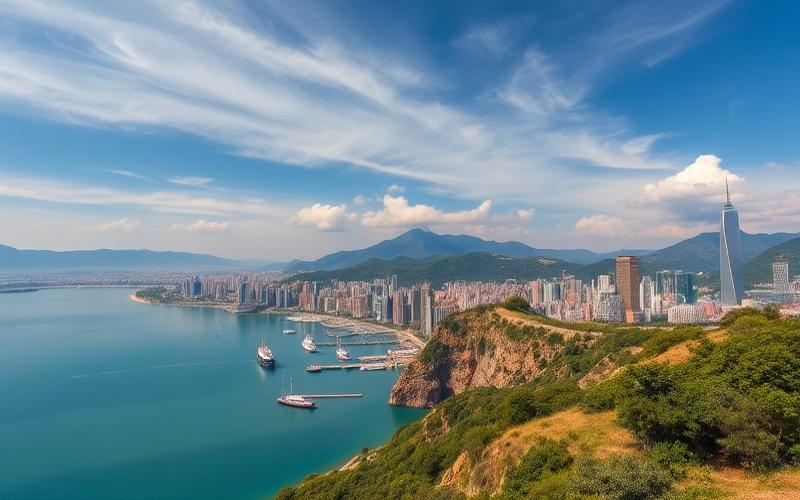
Busan and Haeundae: Korea Facing the Sea
The country’s second city, Busan embodies Korea’s maritime facet: large urban beaches, giant fish markets, temples clinging to cliffs by the water. Among its districts, Haeundae stands out as the most famous seaside showcase, both for Koreans and foreign visitors.
Haeundae Beach, 1.5 km of Sand in the Heart of the City
Located in Haeundae-gu district, Haeundae Beach stretches about 1.5 km. White and golden sand, relatively calm and shallow water, a waterfront lined with skyscrapers and luxury hotels: everything makes it one of the country’s most famous beaches, attracting over 10 million visitors annually.
To get to Haeundae Beach in Busan, several transportation options are available. By subway, take Line 2 (green line) to Haeundae Station, then walk a few minutes along the commercial street Gunam-ro, which leads directly to the sea. By bus, several lines serve the area: Bus 307 provides a direct link from Gimhae International Airport, Express Bus 1001 connects Haeundae to downtown Busan and Gwangalli Beach, and Bus 1003 departs from Busan Station for a trip of about 45 minutes. By taxi from the station, expect about a 40-minute ride.
Access to the beach is free and possible year-round; only swimming is regulated and officially allowed during the summer high season, typically from late June to late August. The rest of the time, Haeundae remains a place for walking, jogging, sea contemplation, or cultural events.
A Coastline Packed with Activities
Haeundae’s success also lies in the impressive number of activities and sites within a very small radius. On the beach itself is the SEA LIFE aquarium, featuring over 10,000 creatures from 250 different species, in spectacular tanks and an underwater glass tunnel. A few steps away, a free foot spa uses the region’s thermal water, next to the tourist information office.
In the background of the beach stands the LCT “The Sharp” Tower, Busan’s tallest skyscraper (411.6 m). It houses the Busan X the SKY observatory (from the 98th to 100th floors) with its “Shocking Bridge” glass walkway, art installations, restaurants, and the world’s highest Starbucks. Nearby, families can visit the Lotte World Adventure Busan theme park (opened in 2022) or try the wheeled luge rides at Skyline Luge Busan.
Along the coastline, several developed walking paths offer multiple viewpoints:
| Location / Route | Features |
|---|---|
| Dongbaekseom (Dongbaek Island) | Former island now connected to the mainland, coastal trails and camellia forest |
| Haeundae Blueline Park | Coastal park with two tourist transports (Beach Train & Sky Capsule) |
| Busan Green Railway | 4.8 km walk on a former railway between Mipo and Songjeong |
| Moontan Road | 3 km forest trail partly parallel to the Green Railway |
| Dalmaji-gil | Scenic road lined with cherry trees, connecting Haeundae to Songjeong |
| Cheongsapo Daritdol Observatory | Glass walkway overhanging the sea, accessible via the Beach Train |
The Haeundae Blueline Park has become an attraction in itself: a small coastal train runs along 5 km of coastline between Haeundae and Songjeong, while a system of colorful panoramic capsules (Sky Capsule) travels 2.3 km between Mipo and Cheongsapo stations. The slow speed of these capsules (2 to 4 people) allows for full enjoyment of the marine landscape.
At the western end of the beach, Dongbaekseom – nicknamed Camellia Island – offers a 30 to 50-minute loop walk through wooded paths, cliff edges, lighthouses, and views of the waterfront and Marine City district. It also houses the Nurimaru APEC House, a building constructed to host the APEC summit in 2005 and now turned into a museum.
On a clear day, it is possible to see from Busan the silhouette of the Japanese island of Tsushima (Daemado), located about 50 km away. This view illustrates Busan’s strategic position on Northeast Asia’s maritime routes.
Festivals and Nightlife
Haeundae is not just about scenery: the district lives to the rhythm of many festivals. In May, a large sand festival transforms the beach into a gallery of ephemeral monumental sculptures. During summer, the beach participates in the vast Busan Sea Festival, coordinating entertainment, concerts, and water activities across several city beaches (Haeundae, Gwangalli, Songdo, Dadaepo, and Songjeong). In winter, the Haeundae Lights Festival illuminates the beach and Gunam-ro avenue with light decorations from mid-November to late January, while a Polar Bear Swim festival challenges the bravest in December. Finally, watching the first sunrise of the year from Haeundae has become a popular New Year’s ritual.
In the evening, the beach and adjacent streets come alive: bars, clubs, karaoke, seafood restaurants, and street stalls attract as many locals as visitors. An “orange tent village,” Haeundae Pojangmacha-chon, sets up on the sand at night to serve shellfish, grilled fish, and soju. At the traditional Haeundae Market, one can sample multiple street foods, including a “luxury” hotteok that has become an attraction in itself.
Jeju, the UNESCO-Listed Volcanic Island
South of the peninsula, Jeju is both South Korea’s largest island and its smallest province. Its oval shape (about 70 km east-west, 30 km north-south) covers nearly 1,846 km², roughly three times the area of Seoul. Nicknamed “Island of the Gods,” it has built a reputation as a honeymoon destination, family vacation spot, and hiker’s paradise.
A Triple UNESCO Crown
Jeju has the rare distinction of having obtained a “triple crown” from UNESCO: inscription as a Natural World Heritage Site, designation as a Biosphere Reserve, and inclusion in the Global Geoparks Network. It was also selected among the “New 7 Wonders of Nature.”
The “Jeju Volcanic Island and Lava Tubes” site has been on the Natural World Heritage list since 2007, the first such recognition for Korea. It covers three major complexes over nearly 18,846 hectares (over 10% of the island’s area), chosen for their landscape quality and geological interest: Hallasan volcano at the center, the Geomunoreum lava tube system in the northeast, and the Seongsan Ilchulbong tuff cone in the east.
Hallasan, Roof of Korea
The country’s highest peak at 1,947 to 1,950 m above sea level depending on sources, Mount Hallasan rises at the island’s center like a massive shield volcano. Its particularity is having formed on a stable continental crust over a hot spot, a rare phenomenon on a planetary scale. At the summit, a large circular crater contains a lake, Baengnokdam (“White Deer Lake”), about 700 m wide east-west, 500 m north-south, 111 m deep, and 1,720 m in circumference.
Area in square kilometers of Jeju Island’s natural reserve, designated since 1966.
Hallasan is also characterized by a record number of secondary volcanoes: no fewer than 368 cones – called oreum in the local dialect – dot the island’s slopes, an exceptional ratio relative to the total area. Some are simple scoria cones, others are tuff cones or rings.
The Geomunoreum Lava Tubes
In the island’s northeast, the lava tube system from the Geomunoreum volcano is considered one of the most impressive in the world. Formed by lava flows between 300,000 and 100,000 years BCE, these underground conduits stretch about 36 km in three main networks, from the volcanic cone (465 m altitude) to the coast.
These caves are distinguished by an exceptional abundance of carbonate speleothems (stalactites, flowstones, “cave coral,” columns) on their walls and floors. This variety and density of formations, typical of limestone caves, contrast with the surrounding dark basalt rock and are unique among known lava caves.
Five major tunnels are included within the World Heritage perimeter:
– Manjanggul, 7,416 m long, with an accessible section revealing lava stalactites, columns, bridges, and even a fossilized waterfall
– Gimnyeonggul, nicknamed “snake cave” for its winding path
– Bengdwigul, a complex labyrinth home to endemic fish and spider species
– Dangcheomuldonggul and Yongcheondonggul, with spectacular speleothems and an underground lake
Only a small portion of this network is open to the public, to limit the impact of visitation.
Seongsan Ilchulbong, the Sunrise Peak
At Jeju’s eastern tip, Seongsan Ilchulbong is a tuff cone born from a Surtseyan-type underwater eruption between 120,000 and 50,000 years ago. It rises 179 m above sea level, with an almost circular crater 570 m in diameter and 90 m deep. Waves have eroded three of its sides, exposing layers of ash and ejecta, making it an open book for geologists.
Originally isolated offshore, the cone is now connected to Jeju by a sand spit 500 m wide, the result of marine deposits over 1.5 km. It is especially famous for its dawn panoramas: every New Year, a sunrise festival gathers crowds to greet the first light of the year. The ascent uses a steep staircase and takes 45 minutes to an hour depending on fitness.
Beaches, Waterfalls, Villages, and Haenyeo
Beyond these three UNESCO sites, Jeju abounds with other places that justify at least three full days on site, especially since the infrequent bus network makes renting a car or scooter very appealing.
Jeju Island offers a great diversity of coastal landscapes. For beaches, notable ones include Jungmun (very popular), Hamdeok (with turquoise, calm waters, highly favored), Hyeopjae, Woljeongri, and Samyang’s black sand beach. The Yongmeori Coast offers a spectacular seaside cliff face. Among emblematic waterfalls are Cheonjeyeon (three falls in a blue-water canyon), Cheonjiyeon (accessible and lit at night), and Jeongbang, one of the few waterfalls in Asia that falls directly into the sea.
Forests complete the picture, with, for example, the Halla Ecological Forest or the ancient Gotjawal forest, where a primary forest of nutmeg trees grows. Culturally, several villages like Seongeup perpetuate unique architectures of lava stone and thatch houses, with volcanic stone walls and an agricultural lifestyle explained in an interpretation center.
The stone statues Dol Hareubang – literally “stone grandfathers” – dot many sites. These 45 original statues, carved from basalt, were seen as protective and fertility-bringing. Finally, the haenyeo, female divers who harvest abalone, seaweed, and shellfish without oxygen tanks, have become a strong symbol of Jeju: most are over 60, some continue diving into their 80s. Their culture has been recognized by UNESCO as Intangible Cultural Heritage, and demonstrations are organized in some coastal villages.
UNESCO Sites, the Backbone of an Itinerary
Beyond Jeju, South Korea now has 17 sites inscribed on the World Heritage List, including 15 cultural and 2 natural sites. Many also appear on the national list of Top 100 Tourist Sites, providing an excellent thread for organizing a grand tour across the country.
Among the most remarkable, several stand out for their accessibility and interest for a first visit:
South Korea is home to several cultural and natural UNESCO World Heritage Sites, reflecting its rich history and biodiversity.
Historic area described as an ‘open-air museum,’ including royal burial mounds (Daereungwon), temples (Bulguksa), Seokguram Grotto, Cheomseongdae Observatory, and Donggung Palace and Wolji Pond.
18th-century ramparts stretching 5.5 km around downtown, offering views of the secondary palace Hwaseong Haenggung.
Seven Buddhist temples illustrating the continuity of this tradition in spectacular natural settings.
Like Dosan Seowon near Andong, they testify to the scholarly culture that structured Joseon society.
Natural site on the southwest coast, crucial wetland for thousands of species, notably migratory birds.
For the traveler wanting to structure an itinerary around these places, the map of UNESCO sites naturally combines with major cities (Seoul, Busan, Gyeongju, Jeju, Andong, Suwon) and national parks (Seoraksan, Bukhansan, Jirisan, Naejangsan), creating an almost comprehensive network across the country.
When to Go and How to Structure Your Trip
South Korea is a country of four very distinct seasons. The generally recommended travel periods are spring (March–May) and autumn (September–November), when temperatures remain mild, the sky often clear, and landscapes particularly spectacular with cherry blossoms or fiery maple leaves. Summer, especially July–August, is hot, humid, frequently rainy due to the monsoon, complicating visits to outdoor sites (palaces, DMZ, villages) but suiting a beach stay in Busan or Jeju. Winter is harsh, especially in the north and mountains, but favorable for winter sports, notably in Gangwon Province, home to several Olympic resorts.
The major holidays of Seollal (Lunar New Year) and Chuseok trigger significant domestic travel and the closure of many businesses. It is generally advised to avoid them for a first trip, unless one wishes to experience them within a Korean family.
Regarding duration, tourism studies recommend a minimum of 5 to 7 days for a first discovery focused on Seoul and its surroundings (palaces, DMZ, Nami, markets), and two to three weeks for a more comprehensive loop including Busan, Gyeongju, Andong, or Jeju. The high-speed rail network (KTX) and domestic airlines – particularly on the Seoul–Jeju route, considered the world’s busiest air route – greatly facilitate travel.
From Seoul’s Markets to Jeju’s Cliffs: A Land of Contrasts
Whether crossing the Freedom Bridge facing the DMZ, climbing the stairs of Injeongjeon at Changdeokgung, getting lost among the crowded stalls of Gwangjang Market, or contemplating Haeundae Beach from a colorful capsule, a common thread emerges: South Korea combines an exceptional density of sites of interest and a rare ability to make past and future coexist within the same, relatively small territory.
The must-see sites of South Korea reveal the country’s history, traditions, and contemporary issues. They bear witness to the scars of war, the strength of Confucianism, cultural creativity, and environmental challenges. The country offers striking contrasts, from the ancestral hanoks of Andong to UNESCO-listed volcanoes, and from futuristic night markets to traditional villages of female divers.
It is likely this ability to offer, in a country very easy to traverse, such a variety of powerful experiences that explains why South Korea, long overlooked compared to some of its neighbors, now stands as one of the most coveted destinations in Asia. For those taking the time to combine capitals, villages, coastlines, and volcanic islands, it offers much more than a mere list of “Instagram spots”: the feeling of having crossed a country in full transformation, firmly anchored in its history yet irresistibly turned toward the future.
Disclaimer: The information provided on this website is for informational purposes only and does not constitute financial, legal, or professional advice. We encourage you to consult qualified experts before making any investment, real estate, or expatriation decisions. Although we strive to maintain up-to-date and accurate information, we do not guarantee the completeness, accuracy, or timeliness of the proposed content. As investment and expatriation involve risks, we disclaim any liability for potential losses or damages arising from the use of this site. Your use of this site confirms your acceptance of these terms and your understanding of the associated risks.
Cyril Jarnias is an independent expert in international wealth management with over 20 years of experience. As an expatriate himself, he is dedicated to helping individuals and business leaders build, protect, and pass on their wealth with complete peace of mind.
On his website, cyriljarnias.com, he shares his expertise on international real estate, offshore company formation, and expatriation.
Thanks to his expertise, he offers sound advice to optimize his clients' wealth management. Cyril Jarnias is also recognized for his appearances in many prestigious media outlets such as BFM Business, les Français de l’étranger, Le Figaro, Les Echos, and Mieux vivre votre argent, where he shares his knowledge and know-how in wealth management.