
 Published on and written by Cyril Jarnias
With about fifty islands and cays scattered across a turquoise sea, the British Virgin Islands offer a concentrated dose of postcard-perfect beaches, spectacular coral reefs, and small patches of land steeped in stories of pirates, mines, and sugar. This territory, often nicknamed “Nature’s Little Secrets,” has become one of the world’s top destinations for sailing, snorkeling, and diving. But beyond the nautical charts, certain sites stand out as absolutely unmissable for any traveler, whether arriving by plane, ferry, or at the helm of a sailboat.
For a complete stay, it is recommended to visit several British Virgin Islands, including Tortola, Virgin Gorda, Anegada, Jost Van Dyke, and the secret coves of Norman Island.
Tortola: Gateway and Balcony Over the Islands
Tortola is the largest island in the archipelago and the main gateway, with Road Town, its lively port, ferries to the other islands, and charter bases attracting sailors from around the world. But beyond its logistical role, the island already holds a number of iconic sites of the British Virgin Islands.
Sage Mountain: The Forest Above the Sea
Perched on the ridge, Sage Mountain National Park overlooks the entire archipelago. With its summit reaching around 1,710 to 1,716 feet, it is the highest point in the British and U.S. Virgin Islands. Here, forget the coconut palms: it’s a mountain forest that resembles a Caribbean version of a “cloud forest,” the result of reforestation and protection efforts since the 1960s.
Seven trails crisscross a mosaic of tropical vegetation and drier areas. Easy loops alternate with more challenging routes, but all offer, on clear days, spectacular views of the Sir Francis Drake Channel and the chains of islands around. On the branches, small birds like the Bananaquit come to peck, while on the ground, humidity nurtures a rich diversity of endemic plants.
Percentage of land territory covered by the network of protected areas managed by the National Parks Trust.
Tortola’s Beaches: Sands, Waves, and Reefs
Tortola boasts several beaches that regularly rank among the most beautiful shores in the Caribbean. They don’t all offer the same vibe, making it easy to craft a custom itinerary.
Cane Garden Bay, a large crescent bay on the northwest coast, blends white sand, shallow waters, and a row of bars, restaurants, and small shops. It’s the liveliest side of Tortola: rentals of Hobie Cats, kayaks, windsurfing, evening music… When cruise ship passengers arrive, the place fills up quickly, but it remains the quintessential “easy” and family-friendly Caribbean beach, with views of old sugar mills scattered in the hills.
At the western end, Smuggler’s Cove plays the opposite role. This “hard-to-reach gem” is earned at the end of an unpaved road, which probably explains why it remains so quiet. A curve of pale sand, turquoise sea, few facilities except a beach bar like Nigel’s, and a reef attracting reef fish and turtles: altogether it is preserved enough to be listed among the best beaches of Tortola in several specialized guides.
Brewers Bay is a wide, discreet beach, ideal for snorkeling in calm water, with a coral barrier home to trumpetfish, barracudas, and octopuses. For surfing, Apple Bay and Josiah’s Bay offer sought-after point breaks from December to March.
Long Bay, southwest of Tortola, stretches nearly a mile of white sand. It’s the place to walk, run, watch the sunset, and, on the east side, enjoy the facilities of the Long Bay Beach Resort. Same logic for Lambert Beach, a large, wide, sandy beach very popular with local families for picnics.
To help you get your bearings, a summary table compares some of Tortola’s favorite beaches.
| Beach | Main Appeal | Key Activities | Vibe |
|---|---|---|---|
| Cane Garden Bay | Lively, family-friendly large bay | Swimming, water sports, bars | Very lively |
| Smuggler’s Cove | Seclusion and snorkeling | Sea turtle watching, lounging | Quiet, pristine |
| Brewers Bay | Reef accessible from the beach | Snorkeling, light camping | Discreet |
| Apple Bay | Surfing waves in winter | Surfing | Sporty, rustic |
| Long Bay | 1 mile of sand for sunset walks | Swimming, strolling | Romantic |
Memories of Sugar and Rum
Tortola is not just about beaches. Its old windmills, distilleries, and colonial buildings tell a story of sugar plantations, slavery, and Atlantic trade, which local authorities are trying to document without embellishment.
Mount Healthy National Park, with its 18th-century mill tower and surrounding ruins, is the remnant of a vast 250-acre estate worked by enslaved labor. This free-access site now serves as an entry point to address this dark chapter of the archipelago’s history.
Down below, near Cane Garden Bay, Callwood Rum Distillery continues one of the territory’s oldest traditions: distilling rum using pot stills. This family-run distillery, in operation for over 200 years, remains true to methods inherited from the colonial era. You can tour the stone buildings, observe the artisanal process, and then move on to tasting. Four samples cost about $1, and a more comprehensive tour runs around $7. A concrete way to connect the glass of rum served on the beach to the island’s economic history.
In Road Town, the 1780 Lower Estate Sugar Works Museum and Her Majesty’s Prison Museum round out this historical panorama: one inside the walls of an old sugar mill, the other in the city’s oldest prison, built in the 18th century, where escaped slaves as well as French and Napoleonic prisoners of war were held.
Finally, for a more botanical break in the heart of the capital, the J.R. O’Neal Botanic Gardens, four acres of themed gardens, condense the different microclimates of Tortola into a small area: a miniature rainforest, a cactus garden, lily ponds, and an orchid pavilion. For just a few dollars, you can stroll among local and exotic species following a small, playful path designed with children in mind.
Virgin Gorda: Granite Sculptures and Secret Coves
Southeast of Tortola, Virgin Gorda unfolds its gentle contours, rounded hills, and a series of coves and bays that have made its reputation. This is where the most famous site in the British Virgin Islands is located, along with other equally remarkable landscapes, often much less crowded.
The Baths and Devil’s Bay: A Unique Mineral Labyrinth
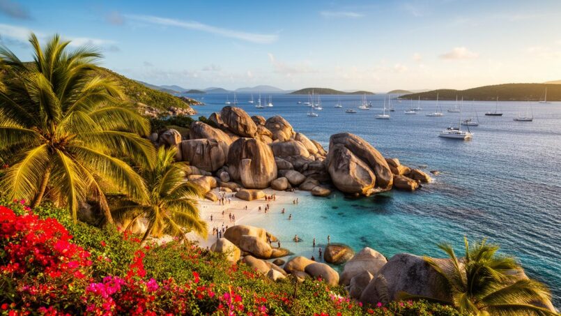
No mention of the must-see sites of the British Virgin Islands would be complete without The Baths. This national park, officially created in 1990 on about 7 acres, occupies the southwestern tip of Virgin Gorda. Its specialty: giant granite boulders, sometimes 12 meters wide, piled up and sculpted by millions of years of erosion.
Originally, magma gradually infiltrated softer volcanic layers, crystallized into granite, and then, over time, the more friable surrounding rock eroded away, leaving these massive boulders exposed. Waves, tropical rain, and wind then rounded the edges, carved passages, and formed caves, narrow corridors, and pools where the sea flows in.
In the British Virgin Islands, the one-way trail at The Baths is equipped for safe exploration. It guides visitors from the parking lot to Baths Beach, then through the maze of giant boulders to the calm Devil’s Bay. To navigate narrow passages, sometimes flooded with a few inches of water, the route is fitted with ropes, ladders, walkways, and stairs. The trail also reveals spectacular scenery, such as the “Cathedral Room,” where light filters between the boulders to illuminate natural pools.
The full loop—descending to the beach, exploring the caves, stopping for a swim, and returning via the dry trail that goes back up to the parking lot—usually takes two to three hours, depending on the crowds. This blend of playful mini-hike, geological exploration, and swimming in clear water explains why The Baths are the most visited attraction in the entire archipelago.
A unique place to relax after a swim, offering an exceptional panoramic view of the sea and surrounding islands.
Enjoy an infinity pool with a direct perspective on the ocean, perfect for relaxing after the effort.
Admire from the restaurant views of Tortola, the Dog Islands, Norman Island, and the famous Sir Francis Drake Channel.
Forgotten Bays and Viewpoints on Virgin Gorda
While The Baths draw the crowds, Virgin Gorda holds other treasures. Savannah Bay, a large arc-shaped beach on the north coast, offers a long strip of nearly deserted sand, a reef protecting the shallow waters, and even a small underwater snorkeling trail used by dive schools like Dive BVI to train beginners. There are virtually no buildings nearby, enhancing the feeling of isolation.
Further on, Gorda Peak National Park protects one of the last examples of Caribbean dry forest in the region. It’s also the highest point on the island, around 1,359 to 1,370 feet. Two clearly marked trails ascend from North Sound Road to the summit, where an observation platform allows you to take in the North Sound, nearby islets like Prickly Pear Island or Eustatia, and the contrast between turquoise coves and arid vegetation.
On the southeast coast, Copper Mine National Park tells a very different story: that of copper mining carried out by miners from Cornwall in the 19th century. On this wave-beaten point, the ruins of the old power plant, shafts, cisterns, and a chimney bear witness to the presence of over 130 workers and their families at the time. The site, designated a national park in 2003, has undergone consolidation work, and an interpretation center is planned to better contextualize this piece of industrial heritage. Beyond the eroded walls, the view of the ocean and cliffs also attracts visitors.
Virgin Gorda Beaches: From Myth to Discreet Coves
The beaches of Virgin Gorda also come in several flavors. To compare some iconic sites, a table allows you to visualize their specifics.
| Beach / Site | Key Feature | Main Interest | Crowds |
|---|---|---|---|
| The Baths / Devil’s Bay | Chaos of granite boulders, caves, natural pools | Playful hike, snorkeling | Very high |
| Savannah Bay | Long nearly deserted sand arc, protective reef | Swimming, calm snorkel, sunset | Low to moderate |
| Spring Bay | Beach dotted with boulders, clear water | Swimming, picnicking | Moderate |
| Little Dix Bay | Private beach of a 5-star resort | Chic lounging, water sports | Resort guests only |
| Nail Bay / Mahoe Bay | Intimate beaches and nearby reefs | Snorkeling from the beach | Rather quiet |
Overall, Virgin Gorda offers a seductive compromise between major tourist icons—The Baths first and foremost—and discreet coves, often accessible via secondary roads or by boat through the North Sound and its many anchorages (Leverick Bay, Saba Rock, etc.).
Anegada: The Flat Atoll, Its Giant Reefs, and Flamingos
North of the archipelago, Anegada breaks completely with the volcanic silhouette of its sisters. No mountains here: the island, the second largest of the British Virgin Islands by area, spans about 15 square miles without exceeding 28 feet in elevation. A simple strip of land set on the sea, surrounded by treacherous reefs.
Horseshoe Reef: Giant Coral Barrier and Ship Graveyard
Around Anegada, Horseshoe Reef forms an incredible coral barrier in the shape of a horseshoe, about 18 miles long, encircling almost the entire island. Sailors both fear and admire it: over 150, even over 300 shipwrecks have been recorded here, from HMS Astraea to 20th-century cargo ships and the Parametta.
The cost of a diving or snorkeling trip with equipment in the Bahamas, in dollars per person.
Access to these protected areas is subject to strict rules: anchoring on coral is prohibited, use of mooring buoys placed by the National Parks Trust or private operators to avoid damaging the seabed.
Northern Beaches: Loblolly Bay, Cow Wreck, and Flash of Beauty
The north side of Anegada lines up a series of beaches that consistently top the lists of “most beautiful shores” in the region. In many rankings by experienced sailors, the stretches of Cow Wreck Beach and Loblolly Bay claim first place.
Loblolly Bay is a beach renowned for its white sand and shallow, turquoise waters. The reefs close to shore allow for snorkeling directly from the beach when conditions are calm. Beach bars like Big Bamboo or Flash of Beauty are set up there and offer fresh products: fish, seafood, ice cream, and drinks.
Cow Wreck Beach, further west, gets its name from a shipwreck carrying a cargo of cattle bones. Today, no more carcasses, but colorful wooden chairs planted in the sand, a sea of an electric green, and a bar, Cow Wreck Beach Bar & Grill, whose “Wreck Punch” and live music sessions have made its reputation. Sunset lovers find one of the most beautiful spectacles in the territory here.
To help you find your way, a table summarizes the main beaches of Anegada.
| Beach | Specialty | Activities | Vibe |
|---|---|---|---|
| Loblolly Bay | Long white sand beach, nearby reefs | Snorkeling, swimming, relaxation | Lively but peaceful |
| Cow Wreck Beach | Very green water, décor of conch shells and wrecks | Swimming, cocktails, sunset | Very relaxed |
| Flash of Beauty | Smaller, wilder cove | Snorkeling in calm sea, tranquility | Intimate |
| Bones Bight | Isolated bay | Snorkeling, walking | Very quiet |
Wildlife, Culture, and Island Slowness
Inland, Anegada contains vast salt ponds and lagoons, especially on the west side of the island, where a colony of pink flamingos, once wiped out by hunting, has been reintroduced. You can observe these elegant birds from designated viewpoints, without approaching nesting areas. The island is also home to the highly threatened Anegada iguana, protected in a dedicated conservation center, as well as a scrub flora typical of dry environments.
Anegada is a sparsely populated island with fewer than 500 residents and only one village, The Settlement. Accommodation consists of small hotels like the Anegada Reef Hotel or the Anegada Beach Club. You’ll find artisans selling jewelry and items made from conch shells. The major annual event is the Lobster Festival, celebrating local spiny lobster prepared in various ways (grilled, curried, buttered) in a Caribbean musical atmosphere. The lobster fishing season generally runs from early November to late July, making it a particularly interesting time to visit the island.
You get to Anegada by ferry from Tortola or Virgin Gorda (about 75 minutes crossing from Road Town, for about $50), by small plane, or by sailboat, provided you handle the shallow approaches well. Once there, it’s best to rent a car, scooter, or bike, or combine taxis and walking. On such a flat island, every mile covered feels like traveling to another end of the world.
Jost Van Dyke: Barefoot Island and Legendary Bars
The smallest of the four main islands, Jost Van Dyke is nonetheless a heavyweight… of Caribbean myth. Nicknamed “The Barefoot Island,” it condenses in a few bays everything that the imagination associates with the Caribbean: white sand, legendary beach bars, live music, anchorages packed with sailboats, and small preserved coves.
White Bay: Star Beach and Beach Bar Paradise
White Bay, a large cove of powdery sand protected by a reef, is regularly ranked among the most beautiful beaches in the Caribbean. Specialized magazines have even placed it in the world’s top 10. What first strikes you is the contrast between translucent water, ideal for swimming and snorkeling along the rocks, and a fringe of bars and restaurants that have shaped the island’s festive reputation.
In the 1970s, at the Soggy Dollar Bar on the island of Jost Van Dyke, bartender Daphne Henderson created the Painkiller cocktail, made with dark rum, coconut cream, pineapple and orange juice, and sprinkled with nutmeg. The bar’s name comes from sailors who swam to the beach with their wet dollar bills. Today, the establishment has developed its own rum brand, a shop, a web radio, and even offers a few guest rooms.
Around, a series of places complete the experience: Hendo’s Hideout, a more “upscale” bar known for its fresh food cuisine, One Love Bar & Grill famous for its lobster quesadillas, Gertrude’s Beach Bar where you measure your own rum from the cooler, Coco Loco’s at the far end of the beach, or Jewel’s Snack Shack serving burgers and punches.
The main activity here, besides swimming, is “bar-hopping” along the beach, late morning or afternoon, when dinghies drop off passengers from anchored sailboats.
Great Harbour, Little Harbour, and the Art of Taking Your Time
On the other side of the hill, Great Harbour concentrates the island’s main village, with its jetty, customs office, a few shops, and famous bars. Foxy’s Tamarind Bar, run for decades by Foxy Callwood, has become a Caribbean legend, especially for its New Year’s Eve party that attracts boats from all over the region, but also for its tavern atmosphere covered in souvenirs, plaques, and flags. You drink strong, you sing, you listen to concerts, you solve the world’s problems while watching the ballet of dinghies.
More peaceful and intimate, Little Harbour (also called Garner Bay) is home to restaurants like Sydney’s Peace and Love, Harris’s Place, or Abe’s by the Sea. They perpetuate the tradition of grilled fish, lobster, barbecue buffets, and even weekly roast pork dinners. Some establishments still operate with an “honor bar”: customers serve themselves at the counter, note their consumption, and pay later.
Between these two bays, a handful of small accommodation options—private villas, beach bungalows, rooms above the bars—allow you to spend several nights there rather than just a day stopover.
Diamond Cay, Sandy Spit, Bubbly Pool: The Wild Side of Jost Van Dyke
East of the island, Diamond Cay is a small marine protected area, a paradise for seabirds and snorkeling enthusiasts in shallow waters. Turtles, rays, and colorful fish schools move around in an easily accessible reef setting. Nearby, a short hike leads to the Bubbly Pool, a large natural basin formed behind a rocky barrier. When the Atlantic swell rushes through a gap, it fills the pool and creates a spectacular “jacuzzi” effect. It’s best to go at high tide or during moderate wave periods, staying cautious on slippery rocks.
Sandy Cay and Sandy Spit are tiny sandy islets, sometimes with a single palm tree, surrounded by translucent water. Their fringing reefs host a rich marine life, including juvenile fish, rays, and turtles. Sandy Cay, formerly a private property of Laurance Rockefeller, was donated to the National Parks Trust in 2007, becoming a protected area where short nature trails can be found.
National Parks Trust of the British Virgin Islands
Norman Island: Hidden Treasures and Caves to Explore
South of the archipelago, Norman Island extends the chain of islands bordering the Sir Francis Drake Channel. Private, nearly uninhabited except for a few tourist facilities, it nevertheless concentrates some of the best snorkeling sites and the most persistent pirate stories in the British Virgin Islands.
An Island That Inspired “Treasure Island”
According to many historians and sailors, Norman Island may have inspired part of the setting for Robert Louis Stevenson’s novel “Treasure Island.” The author never visited, but local lore is full of anecdotes that could fuel an imaginary treasure hunt.
In the mid-18th century, a Spanish galleon, Nuestra Señora de Guadalupe, laden with chests of silver, supposedly saw its crew mutiny under the leadership of one Owen Lloyd. The mutineers allegedly hid dozens of chests on Norman Island, with a total value approaching 250,000 pieces of eight. Alerted, British authorities and the major planters of Tortola supposedly rushed to recover the loot, before returning it (at least partially) to Spain. Other accounts mention a 19th-century discovery of gold coins by a fisherman taking shelter in a cave during a storm.
Sites like Money Bay, Treasure Point, as well as various caves and coves, have over time fueled a reputation of ‘treasure hunting.’ This legend has become an integral part of the tourist experience, attracting visitors with its mystery and history.
The Caves, The Indians, and Other Snorkeling Temples
Beyond the stories of doubloons, Norman Island has established itself as one of the snorkeling capitals of the archipelago. On the west coast, just outside the large bay of The Bight, steep cliffs shelter three semi-submerged caves, called The Caves, deeply cut into the rock. You enter with fins, mask, snorkel, or by dinghy, sometimes with a flashlight to appreciate the play of light in the darkness.
The walls are covered with sponges, encrusting corals, and gorgonians, and the calm waters teem with fish: sergeant majors, parrotfish, trunkfish, puffers, jacks, barracudas, and occasionally lobsters tucked into crevices. In the darkest parts, the experience resembles a night dive, even though you are moving at the surface.
Nearby, the rocky pinnacles of The Indians offer an exceptional site for snorkeling and diving. Despite stronger currents, the topography of arches, overhangs, and drop-offs hosts spectacular marine life, including turtles, eagle rays, large schools of fish, and a high density of corals.
Other spots complete this circuit, such as Spyglass Wall, Angelfish Reef, Kelly Cove, or the anchorages of Benures Bay, Money Bay, and Privateer Bay, so many possible combinations for sailors who want to explore several sites in a day.
The Bight: Lively Anchorage and Floating Bar
On the north coast, The Bight is one of the largest and safest anchorages in the archipelago, with over a hundred moorings for passing boats. At the back of the bay, a sandy beach is home to a seaside restaurant, Pirates Bight, a hangout for crews. Offshore, a floating establishment, the famous Willy T (William Thornton), attracts those seeking a more uninhibited atmosphere: you drink, eat, and dive from the top deck, in a pirate-floating-bar vibe that has become almost a ritual for many sailors.
Around The Bight, a few hiking trails lead to the island’s heights, particularly towards Spyglass Hill, where the view encompasses the entire channel and a good part of the surrounding islands. A reminder that, despite its festive dimension, Norman Island remains a powerful natural setting of arid hills, bushes, and cliffs.
An Archipelago Designed as a Large Natural Park
If these sites have remained relatively preserved despite increasing visitation, it is partly thanks to the network of protected areas established over half a century ago. The National Parks Trust, a non-profit public body created in the early 1960s, now manages over fifty protected sites: terrestrial parks, marine parks, forest reserves, and regulated fishing zones.
This is the total protected area, combining 153.67 km² of land and 82,759 km² of marine space, to preserve coastal ecosystems and historical sites.
For visitors, this means a few simple rules: use reef-safe sunscreen, stay on marked trails, do not touch coral or collect live shells, take your trash with you, and respect signs and flag safety systems (like at The Baths).
Iconic Beaches and Bays: An Ideal Itinerary
On the scale of the archipelago, certain sites consistently appear in the suggestions for “ideal” itineraries proposed by sailors or local guides. Gathered together, they almost map out the must-sees.
| Site / Beach | Island | Why It’s a Must-See |
|---|---|---|
| The Baths & Devil’s Bay | Virgin Gorda | Unique mineral landscape, icon of the archipelago |
| White Bay | Jost Van Dyke | Postcard beach + legendary bars |
| Cane Garden Bay | Tortola | Lively large bay, music, water sports |
| Cow Wreck Beach | Anegada | Absolute tranquility, emerald green water |
| Loblolly Bay | Anegada | Almost endless beach, world-class snorkeling |
| Smuggler’s Cove | Tortola | Turtle and snorkel spot in a secluded cove |
| Sandy Cay / Sandy Spit | Near Jost Van Dyke | Desert islets, shallow reefs, “end of the world” vibe |
| The Caves & The Indians | Norman Island | Caves and rocky pinnacles for snorkeling and diving |
| Savannah Bay | Virgin Gorda | Long wild beach with snorkeling trail |
| RMS Rhone Marine Park (offshore) | Salt Island | Mythical wreck, historical diving |
Many sailors recommend a one-week circuit that strings together several of these stops: departure from Tortola, down to Norman Island, rounding past Peter Island and Cooper Island, up to The Baths and Virgin Gorda, a detour to Anegada for experienced crews, then back via Jost Van Dyke and the nearby islets. Thanks to regular winds (15 to 25 knots from the northeast) and short distances (5 to 10 nautical miles per day on average), the itinerary remains accessible even for less seasoned crews.
Between Sky, Sea, and Memory: A Multi-Layered Destination
What stands out when traveling through the British Virgin Islands is how the layers overlap. On the surface, you find the clichés you came for: white sand beaches, turquoise sea, beach bars, sunsets, rum cocktails served with your feet in the water. But beneath this postcard, the places tell something else.
Remains like the mines of Virgin Gorda and the sugar mills of Tortola bear witness to a colonial past marked by slavery and resource exploitation. The legends of pirates and treasure, especially around Norman Island, are based on documented historical facts. The creation of national parks, such as Sage Mountain, reflects an early desire to protect unique ecosystems, home to species like the world’s smallest lizard and nesting sites for green turtles.
Finally, everywhere, water and wind remain the two connecting threads. The protected sea of the Sir Francis Drake Channel, short line-of-sight crossings, constant trade winds: these conditions have made the British Virgin Islands the “Sailing Capital of the World,” a natural starting point to explore the caves of Norman, the reefs of Anegada, the boulders of Virgin Gorda, the bars of Jost Van Dyke. Whether you travel by sailboat, ferry, or road, these iconic sites form a coherent puzzle: each represents a different facet of the same archipelago, but all leave a lasting impression, like an invitation to return and explore what has not yet been discovered.
Disclaimer: The information provided on this website is for informational purposes only and does not constitute financial, legal, or professional advice. We encourage you to consult qualified experts before making any investment, real estate, or expatriation decisions. Although we strive to maintain up-to-date and accurate information, we do not guarantee the completeness, accuracy, or timeliness of the proposed content. As investment and expatriation involve risks, we disclaim any liability for potential losses or damages arising from the use of this site. Your use of this site confirms your acceptance of these terms and your understanding of the associated risks.

Cyril Jarnias is an independent expert in international wealth management with over 20 years of experience. As an expatriate himself, he is dedicated to helping individuals and business leaders build, protect, and pass on their wealth with complete peace of mind.
On his website, cyriljarnias.com, he shares his expertise on international real estate, offshore company formation, and expatriation.
Thanks to his expertise, he offers sound advice to optimize his clients' wealth management. Cyril Jarnias is also recognized for his appearances in many prestigious media outlets such as BFM Business, les Français de l’étranger, Le Figaro, Les Echos, and Mieux vivre votre argent, where he shares his knowledge and know-how in wealth management.





