
 Published on and written by Cyril Jarnias
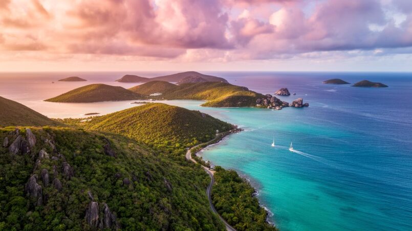
Nestled between the Caribbean Sea and the North Atlantic, the British Virgin Islands form a tiny island territory by size but one of astonishing geographic complexity. Extinct volcanoes, low-lying coral islands, giant reefs, mangroves, hills covered in dry and moist forests, rugged terrain, a very regular tropical climate yet exposed to hurricanes: the archipelago condenses onto barely 150 km² a diversity of landscapes rarely equaled in the Caribbean.
This territory is characterized by a particular geography: no rivers and limited natural resources. This configuration has steered its economic development toward two major pillars: nautical tourism and offshore finance. Today, this archipelago is particularly exposed and vulnerable to the effects of climate change.
A small archipelago at the crossroads of the Caribbean Sea and the Atlantic
The country of the British Virgin Islands is a British Overseas Territory located in the northeastern part of the Caribbean Sea. Geographically, it belongs to the Virgin Islands archipelago, itself part of the Leeward Islands group in the Lesser Antilles, within the Antilles and the larger West Indies region.
Distance in kilometers separating the archipelago from the coast of Puerto Rico.
To the north and east, the North Atlantic imposes its swell and long waves; to the south and west, the Caribbean Sea offers calmer and warmer waters. This dual marine affiliation contributes to the richness of the ecosystems, but also to the complexity of wind and swell patterns that interest sailors and scientists alike.
The entire territory is wholly defined by its coasts (about 80 km of coastline) and its maritime boundaries, including a territorial sea of 12 nautical miles and an exclusive fishing zone of 200 nautical miles, crucial for fishery resources. A detailed maritime boundary has been negotiated with the United States to delimit the area with Puerto Rico and the U.S. Virgin Islands, up to a tripoint near Anguilla.
A mosaic of volcanic and coral islands
The country of the British Virgin Islands comprises about 60 islands, islets, and tropical cays. The exact number varies depending on the definition adopted, but the overall structure is clear: four main islands dominate – Tortola, Virgin Gorda, Anegada, and Jost Van Dyke – surrounded by a string of small emerged lands, including Great Tobago, Salt Island, Peter Island, Cooper Island, Norman Island, Guana Island, Beef Island, Great Thatch, Little Thatch, and Marina Cay.
Of these sixty or so islands, only about 15 to 16 are permanently inhabited. The territory covers approximately 151 to 153 km² of emerged land, roughly 0.9 times the area of Washington D.C. The islands are scattered over nearly 3,450 km² of sea, highlighting the importance of the maritime space relative to dry land.
Tortola, the backbone of the archipelago
Tortola is by far the largest island, with an area of about 54 km². It measures nearly 19 to 20 km in length and about 5 km in width. Its relief is typically volcanic: steep hills, tight ridges, narrow valleys, slopes that plunge abruptly toward deep bays. The coast is indented with numerous coves and anchorages: Cane Garden Bay, major natural harbors like Road Harbour, and more secluded creeks on the north side exposed to the Atlantic.
Tortola Island concentrates over 80% of the population and the main economic activities of the archipelago. It is home to the capital Road Town, the main cruise port, and the center of the offshore financial center. Its rugged terrain, with very steep slopes, determines urbanization: villages and neighborhoods develop in the bays, and winding roads make some journeys both spectacular and tricky.
The highest point of the territory, Mount Sage (or Sage Mountain), rises on Tortola to about 521 to 523 meters in altitude. Its upper slopes receive much more rain than the coast, allowing the development of forest formations close to tropical rainforest, protected within the Sage Mountain National Park.
Virgin Gorda, between granite heights and The Baths
Virgin Gorda covers about 21 km². It stands out for its dual geographic personality. To the north and center, the island rises to over 400 meters in altitude, with the summit Gorda Peak (417 m). The relief is vigorous, carved with ravines and valleys. The soils, derived from volcanic and intrusive rocks, support dry forests, scrublands, and on the better-watered slopes, denser forests.
In the south of the island, the relief lowers to form a flat area called ‘The Valley’, centered around Spanish Town, the second town and former capital. This less constraining topography offers space conducive to the development of various infrastructures: there is a marina, a small town, a former copper mining area, and several hotels.
Virgin Gorda is world-famous for “The Baths”, a spectacular geological site: enormous rock boulders, often described as granite, piled up at the edge of the sea, creating corridors, arches, and natural pools where the waves surge in. This unique landscape illustrates the power of coastal erosion processes and the long geological history of the island.
Anegada, the coral exception and the great reefs
Anegada completely breaks with the physiognomy of the rest of the archipelago. Here, no volcanic mountains: the island is a vast limestone and coral plateau extremely low, whose altitude nowhere exceeds 10 to 15 meters, or only 8 meters by some measurements. A large part of the surface is occupied by salt marshes, sand dunes, and lagoons, with a large central salt pond known as Red Pond.
This low elevation and the limestone nature of the soils make the island particularly vulnerable to sea level rise, storms, and salinization of aquifers. Fresh water is scarce and often brackish, severely limiting agriculture and vegetation, dominated by salt-tolerant species.
Anegada is surrounded by a vast reef system, including Horseshoe Reef, the largest barrier reef in the Caribbean (29 km long, about 77 km²). The reefs around the island cover nearly 380 km². These ecosystems, rich in biodiversity but fragile, are the subject of many conservation programs.
Jost Van Dyke and the neighboring small islands
Jost Van Dyke, with about 10 km², returns to the typical profile of the archipelago’s volcanic islands: steep relief, hills culminating at Majohnny Hill (about 321 meters), narrow valleys. Villages have settled at the back of the most sheltered bays, such as White Bay, famous for its beaches and seaside establishments.
Around, a series of small islands complete the geographic puzzle: Peter Island, Norman Island, Cooper Island, Salt Island, Great Tobago, Guana Island, Beef Island, Great and Little Thatch, Marina Cay… Most are modest in size, often little or uninhabited, but some host private resorts, beach clubs, or research stations, such as Guana Island known for its biodiversity.
Summary of the main islands
To better visualize the orders of magnitude, we can summarize some key physical data:
| Main Island | Approximate Area | Geological Type | Approximate Maximum Elevation |
|---|---|---|---|
| Tortola | 54 km² | Volcanic (pyroclastics, diorite, etc.) | Mount Sage ~521–523 m |
| Virgin Gorda | 21 km² | Volcanic / intrusive rocks | Gorda Peak ~417 m |
| Anegada | 36–40 km² | Coral and limestone | ~8–15 m |
| Jost Van Dyke | 8–10 km² | Volcanic | Majohnny Hill ~321 m |
A geological architecture shaped by tectonic plates
From a geological perspective, the country of the British Virgin Islands extends eastward the faulted massifs of Puerto Rico. The islands emerge from a submarine ridge that, during the Pleistocene, formed a continuous land block with Puerto Rico before being partially submerged by rising waters.
This archipelago formed on a ridge at the boundary of the Caribbean and North American plates, an active tectonic zone that fostered volcanism. Although volcanic activity is now extinct, the subsoil is mainly composed of igneous rocks (basalt, diorite, tonalite), giving a broken relief characterized by low plateaus and many sloping slopes.
Soils are often shallow, rarely more than 50 cm, friable, sensitive to erosion once vegetation cover is lost. On some parts of Virgin Gorda, giant rock boulders reaching up to 10 meters bear witness to ancient fracturing and mass deposition events.
Unlike the other islands of the archipelago, Anegada formed later on coral accumulations and carbonate deposits, resting on an ancient basement. Its very low relief makes it a particularly exposed territory and a privileged study site for observing the impact of sea-level rise on coral islands.
Even though the region lies on the Caribbean plate considered relatively stable, the archipelago still records light earthquakes, linked to the continuous movements of neighboring plates. These tremors rarely cause destruction but remind us of the turbulent tectonic origin of these landscapes.
A territory without rivers, with paradoxical hydrography
One of the most striking features of the physical geography of the country of the British Virgin Islands is the total absence of permanent rivers. Despite a tropical climate and sometimes abundant rainfall, the steep volcanic reliefs, shallow soils, and porous substrates lead to rapid infiltration and direct runoff to the sea via small ravines (ghauts) that carry water only during heavy rains.
Thus, there are no rivers or large natural lakes. Surface freshwater is limited to small artificial ponds or “minidams,” primarily intended for agriculture, whose total capacity barely exceeds 14,000 m³, and a few seasonal pools.
Water supply relies mainly on three sources: wells, rainwater harvesting, and seawater desalination. The situation is complicated by often brackish aquifers (especially on Anegada) and poor soils. On Tortola, a few perennial springs exist but are insufficient to cover the combined needs of the population and tourism.
This scarcity explains why the archipelago must manage water as a particularly precious resource, despite respectable annual rainfall. The hydrography thus boils down to a mosaic of salt ponds (especially on Anegada), flooded mangroves, coastal lagoons, and an omnipresent sea, but few natural freshwater reserves.
Dry forests, moist forests, mangroves, and reefs: a patchwork of ecosystems
On barely 150 km², the country of the British Virgin Islands presents remarkable ecological diversity. It belongs to two major terrestrial ecoregions: the Leeward Islands moist forests and the Leeward Islands xeric scrub (dry forests). Altitude, exposure to wind and rain, soil type, and proximity to the sea create a mosaic of environments.
At the bottom of slopes and in the driest areas, vegetation consists of scrub, cacti, thorny thickets, tree savannas. Higher up, on slopes facing the trade winds, denser forests develop, with species such as mahogany, some local cedar species, cocoa, wild orchids. On ridges moistened by clouds, especially near Mount Sage or on the heights of Virgin Gorda, formations close to montane tropical rainforest establish themselves.
Forest statistics indicate that about 24% of the land area is still covered by forests, i.e., 3,620 hectares in 2020, a slight decline from the 3,710 hectares recorded in 1990. The remaining land is divided between agricultural areas (about 20% arable, 6.7% permanent crops), pastures, built-up areas, and various fallow land.
Mangroves, covering about 580 hectares (75% of which on Anegada), play a crucial role as nurseries for marine species, sediment filters, and natural protection against hurricanes. Their partial destruction due to real estate development increases coastal erosion.
On the sea side, coral reefs envelop the archipelago, with estimated areas of about 380 km². They harbor diverse fauna: colorful reef fish, sea turtles such as the leatherback turtle, rays, dolphins, and even occasionally passing humpback whales. Seagrass beds, sandy expanses, and rocky bottoms complete this underwater diversity.
Road Town, capital between sea and hills
The capital, Road Town, perfectly illustrates the geographic constraint weighing on urbanization. The town is located on the south coast of Tortola, approximately in the middle of the island, on the west shore of a large horseshoe-shaped bay, Road Harbour. Its coordinates are approximately 18°25’53’’ North and 64°37’23’’ West.
Framed by hills, facing a deep roadstead, Road Town developed on a narrow coastal strip, then on land reclaimed from the sea, such as at Wickham’s Cay, a vast landfill area of about 27 to 28 hectares. This artificial district now hosts numerous tourist and commercial facilities.
The population of Road Town, capital of the British Virgin Islands, is estimated between 10,000 and 15,000 inhabitants.
The territory’s main airport, Terrance B. Lettsome International Airport (IATA code: EIS), is located on the neighboring island of Beef Island, connected to Tortola by a bridge. This configuration again illustrates the lack of flat space on Tortola itself: to lay an airstrip, it was necessary to use an adjacent low island. Long-distance air connections largely go through the airport of Saint Thomas in the U.S. Virgin Islands, highlighting regional dependency.
A mild tropical climate but under the threat of hurricanes
In the tropics, near the 18th parallel north, the country of the British Virgin Islands enjoys a tropical savanna climate (close to monsoon climate) strongly moderated by the trade winds. Temperatures vary little throughout the year: the air remains warm, the seawater also, making it a sought-after winter destination for North American and European visitors.
Typical values at Road Town give a good idea of the thermal regime:
| Period of the Year | Average Max. Temperature | Average Min. Temperature |
|---|---|---|
| Summer (June–Sept.) | ~32 °C | ~24–26 °C |
| Winter (Dec.–Mar.) | ~29 °C | ~21–23 °C |
The annual range between average maximums rarely exceeds 3 or 4 degrees, meaning that for human perception, seasonality relies more on rainfall and trade winds than on temperature.
Average annual rainfall is around 1,150 mm, with marked differences between the heights and the coast. On the upper slopes of Mount Sage, it can exceed 2,000 mm per year, while the driest areas remain below 760 mm. Showers are often brief, in the form of downpours and squalls, rather than continuous rain.
Costa Rica experiences precipitation about 170 days per year, nearly half the days of the year.
Dry season, wet season, and cyclone season
We distinguish a drier season, centered on the months of February to July, and a wet season that overlaps most of the Atlantic hurricane season, from June to November. Average relative humidity is around 76 to 79%, higher during the rainy season, sometimes giving a heavy feeling despite the steady trade winds.
The most feared risk remains that of hurricanes and tropical storms. Statistically, the archipelago would have suffered on average about four hurricanes per century, especially between August and October. But recent decades have shown an intensification of these phenomena. Hurricane Irma, on September 6, 2017, devastated a large part of the territory, particularly Tortola, causing four deaths and material damage compared by some observers to that of a bombed zone.
Vulnerability is mainly due to geography (fragmented islands, terrain accelerating winds, densely populated coasts) and dependence on coastal infrastructure. The destruction of mangroves and coastal urbanization have reduced the territory’s natural capacity to absorb the impact of storm surge.
Wind, sunshine, and always warm sea
Trade winds dominate from the east, with, during the so-called “Christmas winds” season (November to January), northeast winds that can reach 15 to 20 knots, sometimes more. From February, the flow shifts more to the east, then toward the southeast around June, before weakening in September–October when high pressures weaken. For sailors, these seasonal variations condition routes and anchorages, the archipelago being one of the world’s leading destinations for sailing yachting.
Sunshine is generous: more than 3,000 hours of sun per year, i.e., between 7 and 9 hours daily on average. Ultraviolet radiation reaches high indices, often between 7 and 11, which implies risks of rapid burns for unprotected skin.
Sea temperature remains pleasant all year round, ranging from 25 °C in winter (January–February) to 29 °C in late summer (September–October). This thermal consistency contributes to the popularity of beaches and water activities, but also promotes, in case of additional warming, episodes of coral bleaching.
A human geography driven by relief and sea
The distribution of the population illustrates the physical constraint of the territory. Out of just over 30,000 inhabitants, more than 23,000 live on Tortola, the vast majority in or around Road Town and other accessible bays on the south coast. In 2010, it was estimated that about 83% of residents lived on this island.
Virgin Gorda, Anegada, and Jost Van Dyke host the remaining inhabitants, supplemented by a few smaller communities on Cooper Island, Great Camanoe, and other islands. Some lands, like Guana Island or isolated bays, are reserved for private resorts or conservation activities.
Rugged topography limits urbanization to flat coastal areas and makes road construction expensive. This relief, combined with the scarcity of fertile soils, prevents large-scale agriculture, forcing the country to import almost all its food and fuel.
The economy relies almost exclusively on two pillars: tourism (beaches, cruises, yachting, diving, hiking) and offshore financial services. Geography plays a dual role here: an asset, thanks to postcard landscapes and the multiplicity of anchorages; and a constraint, with the difficulty of housing, supplying, and protecting infrastructure concentrated on a limited coastline.
A coastline on the front line: bays, mangroves, and ports
With 80 km of coastline, but very few truly wide beaches, the country of the British Virgin Islands sees almost all its activities aligned along the seafront. The bays make it an ideal territory for pleasure boating: numerous well-sheltered coves, relatively calm waters on the Caribbean side, short-distance anchorage possibilities between islands.
Road Harbour in Road Town is the main port of entry for cargo ships, ferries, and cruise ships, as well as a major center for sailboat charters. For smaller charters and private yachts, bays like Cane Garden Bay (Tortola), Spanish Town (Virgin Gorda), or the anchorages of Jost Van Dyke are also used.
Mangroves and lagoons, particularly around Anegada but also in some coves of Tortola and Virgin Gorda, play a buffer role during storm events, slowing down swell and trapping sediments. Yet, they have often been backfilled or cut through to build marinas, roads, and tourist infrastructure, increasing the vulnerability of coasts to erosion and storm surges.
Coral reefs themselves form a natural barrier against ocean swell. Their degradation under the combined effect of warming, pollution, sedimentation, and diseases such as Stony Coral Tissue Loss Disease (SCTLD) directly threatens beach stability and the safety of built-up areas behind them.
A territory heavily dependent on its environment
Despite “natural resources” considered negligible in classic economic classifications (no major active mineral deposits, little fresh water, no large agricultural plains), the country of the British Virgin Islands lives and thrives through its geography: pleasant climate, landscapes, clear sea, reefs, protected anchorages. It is precisely this natural capital that attracts visitors and investors.
But this same geography engenders structural fragilities:
Steep relief makes agriculture difficult and accelerates erosion after clearing. The lack of surface freshwater requires costly infrastructure like wells and desalination plants. Development is concentrated on a narrow coastline, exposed to sea-level rise and storms, while low-lying coral islands are directly threatened by sea-level rise.
Land use data show how delicate the balance is. About 46 to 47% of land is considered agricultural or pasture (if we aggregate the different categories), but the areas actually cultivated remain limited, and the vast majority of food is imported. The remaining forests play a crucial slope stabilization role but face pressure from urbanization, grazing, and infrastructure projects.
A geography under climate pressure
At the territory level, the impact of climate change is already visible through several geographic indicators. Hurricanes seem more frequent and more powerful; the sea is warming, intensifying coral bleaching episodes; gradual sea-level rise worsens coastal erosion, especially on low islands and beaches heavily used by tourism.
This is the percentage of local plant species whose risk of extinction could significantly increase with a prolonged rise in temperatures.
Mangroves, already sacrificed in some places to make way for marinas or landfill, find themselves on the front line. Their decline reduces the natural capacity of the coastline to absorb shocks, whether from storm surges or flash floods in ravines.
The sea, economic and ecological backbone
Beyond the thin strip of emerged land, it is the maritime space that gives the country of the British Virgin Islands its true dimension. Its exclusive fishing zone of 200 nautical miles contains valuable fishery resources: pelagic fish (marlin, wahoo, kingfish, sailfish, tarpon), reef fish, and other species that support a growing commercial fishery. If the contribution of this activity to GDP remains modest, it plays an important role for local food and fresh fish exports.
Sailing is the main tourist activity of the archipelago, favored by short distances between islands, the diversity of landscapes, and the richness of reefs to explore. To protect the seabed, authorities have installed mooring buoys to avoid direct anchoring on corals.
These intensive uses impose fine management of the marine space: regulated anchoring zones, marine reserves, prohibitions on anchoring in seagrass or reefs, control of waste and wastewater discharges. Membership in the British “Blue Belt” program and various international biodiversity agreements testify to the desire to better integrate the geographic — and ecological — dimension into planning.
A political geography on a small but complex scale
Politically, the country of the British Virgin Islands forms a unitary state without large internal administrative divisions, but divided into nine electoral districts. Eight of them lie wholly or partly on Tortola (including some satellite islands), while the ninth brings together Virgin Gorda and Anegada. This division reflects the demographic concentration on the main island while ensuring representation for the less populated islands.
The main centers of services and public life are Road Town (capital), Spanish Town on Virgin Gorda, as well as the small centers of Anegada and Jost Van Dyke. The organization of the territory depends heavily on maritime links, provided by a network of regular ferries that connect the islands to each other, mainly during the day.
On the roads of Tortola, where traffic drives on the left, vehicles are mostly left-hand drive, imported from the United States – a daily paradox on narrow, winding roads sometimes bordered by ravines. This situation once again illustrates how geography conditions even the details of daily life.
An island identity shaped by relief and sea
Over the centuries, the geography of the country of the British Virgin Islands has shaped its history and identity. The first Amerindian inhabitants, then the European colonists and enslaved African populations, had to contend with hills without rivers, cramped lands, natural anchorages, and a fish-rich sea.
The evolution of the islands is marked by the influence of relief, access to the sea, and regional networks. Spanish Town prospered thanks to a copper mine before converting to tourism from the 1960s. Tortola became a global center for offshore finance. These developments are reinforced by close cross-border ties with Puerto Rico and the U.S. Virgin Islands.
Today, geography continues to play a key role: it attracts visitors, sets physical limits on development projects, and regularly reminds, with the passage of each hurricane, that the exceptional beauty of this archipelago comes with great vulnerability.
In this context, thinking about the future of the country of the British Virgin Islands implies integrating its geography into all decisions: preserving forests on slopes, restoring mangroves, strengthening reefs, planning construction zones considering sea-level rise, managing water as a scarce resource, and recognizing that this territory, a tiny green and rocky spot in the blue Caribbean, depends more than ever on the delicate balance between its land, its sea, and its climate.
Disclaimer: The information provided on this website is for informational purposes only and does not constitute financial, legal, or professional advice. We encourage you to consult qualified experts before making any investment, real estate, or expatriation decisions. Although we strive to maintain up-to-date and accurate information, we do not guarantee the completeness, accuracy, or timeliness of the proposed content. As investment and expatriation involve risks, we disclaim any liability for potential losses or damages arising from the use of this site. Your use of this site confirms your acceptance of these terms and your understanding of the associated risks.

Cyril Jarnias is an independent expert in international wealth management with over 20 years of experience. As an expatriate himself, he is dedicated to helping individuals and business leaders build, protect, and pass on their wealth with complete peace of mind.
On his website, cyriljarnias.com, he shares his expertise on international real estate, offshore company formation, and expatriation.
Thanks to his expertise, he offers sound advice to optimize his clients' wealth management. Cyril Jarnias is also recognized for his appearances in many prestigious media outlets such as BFM Business, les Français de l’étranger, Le Figaro, Les Echos, and Mieux vivre votre argent, where he shares his knowledge and know-how in wealth management.





