
 Published on and written by Cyril Jarnias
On a European scale, Slovenia resembles a pocket-sized country. With just over 20,000 km² and about 2.1 million inhabitants, you could drive across it in a day. Yet, this compact territory boasts an impressive concentration of natural environments, climates, terrains, and landscapes. It is this constant contrast – between the Alps and the Adriatic, the Pannonian plains and the karst plateaus, dense forests and marshes – that makes the geography of Slovenia a subject in its own right.
A Strategic Location at the Crossroads of Four Worlds
Slovenia is nestled in the heart of the continent, where Central Europe and Southeastern Europe meet. It shares land borders with four neighbors: Italy to the west, Austria to the north, Hungary to the northeast, and Croatia to the south and southeast. On the sea side, a coastal strip of about 47 km opens the country to the Adriatic Sea, in the Gulf of Trieste.
Slovenia is located at the crossroads of four major European regions: the Alps, the Dinaric Alps, the Pannonian Plain, and the Mediterranean area. Its territory extends between the 45° and 47° north latitude and the 13° and 17° east longitude. The 15th meridian runs almost through its center, near the country’s geometric center located in Slivna, in the municipality of Litija.
A simple glance at its dimensions also recalls the human scale of this country. The maximum distance from north to south is about 163 km, and from east to west about 248 km. In area, Slovenia is slightly smaller than the U.S. state of New Jersey. Yet, on this small territory, nearly 90% of the land is situated above 200 meters in altitude, making it a decidedly mountainous and hilly country.
Borders and Maritime Access
The layout of the borders highlights both the landlocked nature and the limited but strategic maritime access. The longest border is with Croatia, reaching about 670 km, followed by Austria (330 km), Italy (around 280 km, depending on sources), and Hungary (102 km). In total, Slovenia has just over 1,080 km of land borders.
This is the length in kilometers of the Slovenian coast on the Gulf of Trieste, which concentrates its main ports and seaside resort.
Terrain Dominated by Mountains and Forests
What immediately strikes you when looking at the physical map of Slovenia is the power of the terrain relative to the country’s size. The average altitude is 557 m, and only the distant areas of the Pannonian Plain and a few intramontane basins truly escape the hilly or mountainous topography.
The Alps, the Backbone of the North
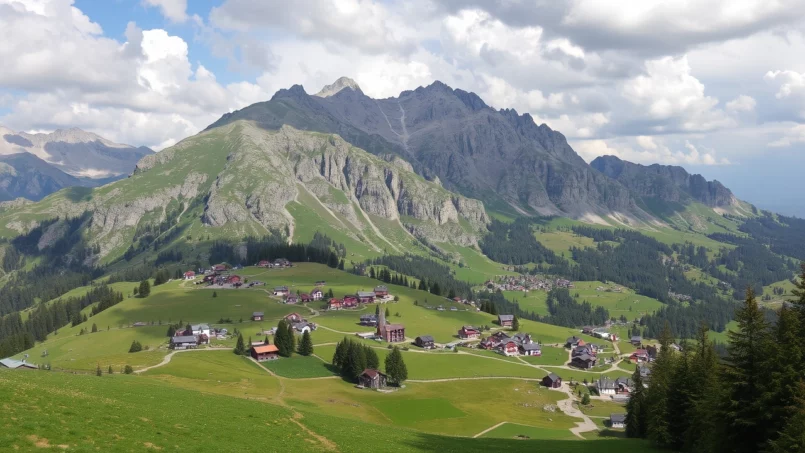
In the north and northwest, the country is dominated by several Alpine massifs. The Julian Alps occupy the northwest and are home to the country’s emblematic peak, Triglav (2,864 m), which features on the flag and coat of arms. To the east, the Kamnik–Savinja Alps and the Karavanke range extend the Alpine arc to the Austrian border, while the Pohorje massif rises in the northeast, above Maribor.
The Slovenian mountains structure vast glacial valleys, like those of the Soča and the Savinja, and are home to glacial lakes such as Bled and Bohinj. A large part of these northwestern terrains is protected within Triglav National Park, the largest protected area in the country.
Karst Plateaus and Interior Hills
Heading towards the center of the country, the terrain softens without becoming flat. Broad wooded hills and plateaus structure what could be called “interior” Slovenia. Around Ljubljana, the capital, you find the Ljubljana Basin, framed by small mountain ranges and the Ljubljana Marsh, a vast wetland area listed as a UNESCO World Heritage Site.
To the southeast of the capital stretches the Karst Plateau (Kras), which gave its name to karstification, the characteristic landscape of limestone rocks with sinkholes, dolines, disappearing streams, and cave systems. Here, powerful rivers like the Reka disappear underground only to resurface sometimes much farther away, having carved spectacular underground canyons like those in the Škocjan Caves.
Farther south, the Javornik hills mark the beginning of the Dinaric Alps, which extend towards Croatia and form the mountainous spine of the Western Balkans. These wooded and often inaccessible terrains are home to dense forests and spectacular wildlife, including one of the strongest brown bear populations in Europe.
The Pannonian Plain and the Lands of the East
In contrast to the mountains, the east and northeast of the country open onto the western edge of the Pannonian Plain. In the Prekmurje region and along the valleys of the Mura and Drava rivers, the terrain becomes distinctly gentler, with vast floodplains, vine-covered hills, and more open agricultural landscapes. This is where a large part of the arable land is concentrated, on some of the most fertile soils in the country.
Even in these regions, Slovenia remains far from the vast flat expanses of other European countries. Valleys are narrow, hills are numerous, and land use is fragmented, which explains the small-scale agriculture and highly divided land parcels.
A Country of Waters: Rivers, Watersheds, and Lakes
In such a confined territory, Slovenia’s river network is surprisingly dense. There are nearly 27,000 km of watercourses if rivers and streams are counted, equating to a density of about 1.33 km of river per km². The country is home to 59 rivers considered “major” and more than 300 lakes, natural or artificial.
Two Major Destinies for Slovenian Waters
Slovenia is clearly divided between the Black Sea and Adriatic Sea watersheds. Approximately 81% of the territory (over 16,400 km²) belongs to the Black Sea watershed, via the Danube, while the remaining 19% (nearly 3,850 km²) drains into the Adriatic.
This distribution is reflected in the hierarchy of watercourses:
| Watershed | Share of Territory | Main Rivers |
|---|---|---|
| Black Sea (Danube) | ~81% | Sava, Drava, Mura, Krka, Savinja, Kolpa (part) |
| Adriatic Sea | ~19% | Soča, Vipava, Reka, Dragonja, Rižana, Cerknica |
The main sub-basins are those of the Mura, the Drava, the Sava (which includes the Kolpa), and the Adriatic rivers.
Major Structuring Rivers
The Sava is the longest river connected to the country. With a total course of 947 km, 221 km flow through Slovenia. It originates from the confluence of the Sava Dolinka (55 km) and the Sava Bohinjka (41 km), the latter itself flowing from Lake Bohinj. From there, the Sava traverses part of the country before heading towards Croatia and then Serbia, where it joins the Danube.
The Drava and Mura, tributaries of the Danube, are major hydroelectric resources for Slovenia. The Drava stretches for 707 km (of which 142 km in Slovenia) and the Mura for 438 km (of which 95 km in Slovenia). These rivers, heavily engineered, especially the Drava, contribute to hydropower accounting for about one-third of the national electricity production.
On the Adriatic side, the Soča (Isonzo in Italian) is the other great river hero. It is 138 km long, with 96 km in Slovenia, and originates in the Trenta Valley, in the heart of Triglav National Park. Its emerald green color and steep valley make it one of the most photographed landscapes in the country. Farther south, rivers like the Vipava, Reka, Dragonja, or Rižana complete the coastal network.
Singular Rivers and the Smallest River
Slovenia is also home to more discreet but fascinating watercourses. The Reka, for example, disappears underground for about 38 km, carving the Škocjan cave system. The Jezernica, flowing from the “wild” lake Divje jezero, is often cited as the shortest river in the country, measuring only 55 meters before joining the Idrijca.
Hydrological diversity is also illustrated in the riverine landscapes: narrow gorges like Vintgar Gorge on the Radovna, broad alluvial plains of the Mura, karst canyons in limestone plateaus, or border rivers like the Kolpa, which serves as a natural border with Croatia for nearly 118 km.
Description of Slovenian riverine landscapes
Glacial, Intermittent, and Reservoir Lakes
Regarding lakes, Slovenia has 321 bodies of water classified as lakes, whether natural, intermittent, or reservoirs. The two best known are the glacial lakes of the Julian Alps: Bled (147 hectares) and Bohinj (318 hectares), the latter being the largest and deepest permanent lake in the country. Lake Bled is home to the country’s only natural island, topped with a church, which has become a tourist icon.
Another star is Lake Cerknica, on the karst plateau of the same name, a spectacular intermittent lake: when completely full, its surface can reach 2,500 hectares, fluctuating between 20 and 30 km². In the dry season, it almost entirely disappears, giving way to wet meadows. The wild lake Divje jezero, meanwhile, is the deepest known lake, with over 160 m measured in its siphon.
A Crossroads Climate: From Alpine to Sub-Mediterranean
The geography of Slovenia explains an astonishing climatic mosaic over a short distance. To simplify, we can distinguish three major influences: Alpine, continental, and Mediterranean, to which subpolar conditions are added locally on the highest peaks.
On the coast, the climate is sub-Mediterranean, with hot, dry summers and mild, wet winters. Inland, most of the country experiences a temperate climate of an oceanic or continental type, with cold winters and warm summers. In the mountains, winters are harsh, snowfall is frequent and long-lasting, and summers remain cool.
Climatic Classification and Regional Variations
Climatologists describe the Slovenian palette using the Köppen classification:
| Zone / Region | Climate Type (Köppen) | Main Characteristics |
|---|---|---|
| Adriatic Coast | Cfa (humid subtropical) / sub-Mediterranean | Warm summers, mild winters, marked marine influence |
| Most of the country | Cfb (temperate oceanic) | Distinct seasons, well-distributed rainfall |
| Plateaus and northern mountains | Dfb (continental) | Warm to moderate summers, cold winters |
| High mountains | Dfc / ET (subpolar, tundra) | Very cold winters, very cool summers, persistent snow |
In the broader Mediterranean zone (coast and immediate hinterland), winter temperatures rarely stay below freezing for long, although they can occasionally be lowered by the cold northeastern wind called the bora (burja). In summer, maximum temperatures frequently exceed 27°C in June and July.
Presentation of the climatic characteristics of Slovenia’s continental regions, with cool summers that can experience heatwaves, and cold winters.
Summer highs generally hover around 20°C, although heatwave episodes can occur.
In the east, in the Prekmurje region, summers are warmer with temperatures well above 21°C in July.
From November to February, sub-zero temperatures are frequent in these continental regions.
In the mountains, winter can extend into spring, with snow sometimes remaining until June near the highest ridges. This is notably the case around Triglav and the high chain of the Julian Alps.
Abundant Rain and Regional Winds
Slovenia is characterized by generally high precipitation, but it varies greatly by region. The west-facing mountain slopes receive over 2,000 mm of rain per year, and some particularly exposed slopes can exceed 3,000 mm. Conversely, the plains and hills of the far east sometimes fall below 900 mm annually.
Spring and autumn are often the wettest seasons, particularly in transition zones between Mediterranean and continental influences. Snow remains frequent in winter in continental and Alpine regions, even though the snowpack tends to shrink and melt more quickly on the plains.
Local winds complete this picture. The bora, a very cold and turbulent wind, blows mainly on the coast during the colder half of the year. Conversely, the jugo, a warm, humid south wind, brings clouds and rain to the coast. In the Alps, the foehn regularly manifests as a warm, dry wind descending from the mountains, sometimes responsible for rapid temperature increases. Overall, the country is less windy than Western Europe, as the mountain massifs act as a screen.
A Sea of Forests: Structure, Biodiversity, and Uses
From a geographical point of view, Slovenia is almost as much a country of forests as it is of mountains. According to the most recent data, about 60 to 62% of the territory is forested, equating to over 1.09 million hectares. This rate places it among the most forested countries in Europe, behind Finland and Sweden if considering the proportion of forested area.
Forest Composition and Altitudinal Distribution
Slovenian forests are mostly composed of beech (pure beech or beech-fir forests), supplemented by beech-oak mixes, as well as spruce, fir, and pine at higher altitudes. As altitude increases, forests gradually give way to juniper formations and alpine meadows, up to the tree line which lies around 1,700–1,800 m.
The soil structure and history of human occupation mean that many current forests have grown on former abandoned agricultural land: forest cover increased from about 36% in 1875 to 44% in 1947, and has continued to grow since. Today, forests sometimes occupy even the summits of the steepest hills, those with slopes often exceeding 15°.
The number of forest owners in France, illustrating extremely fragmented ownership.
Exceptional Biodiversity and Iconic Species
This forest mosaic and the diversity of climates explain the country’s biological richness. Four major terrestrial ecoregions meet in this territory: Dinaric Mountains mixed forests, Pannonian mixed forests, Alps conifer and mixed forests, and Illyrian deciduous forests. To these are added karst environments, wetlands, and Mediterranean habitats on the coast.
The typical large fauna of Central Europe is still well present. Brown bear populations are estimated at about 450 individuals, and wolves at 40–60 individuals. The Eurasian lynx, chamois, Alpine ibex, red deer, roe deer, and wild boar complete this picture. In beech forests, you also find the edible dormouse, an emblematic species of European deciduous woodlands.
The clear mountain waters are home to the marble trout (Salmo marmoratus), a native species. Karst areas are famous for the olm, a cave-dwelling amphibian adapted to life in darkness. On the coast, the bottlenose dolphin is regularly sighted. The avifauna includes notable species such as owls, raptors, woodpeckers, and white storks, the latter nesting mainly in the countryside of Prekmurje.
Protected Areas and the Natura 2000 Network
Aware of this heritage, Slovenia has developed a very dense protection network. One national park – Triglav National Park – alone covers 840 km², the largest protected area in the country. There are also several regional parks (Inner Carniola, Kozjansko, Škocjan Caves, Pohorje, among others) and several dozen landscape or natural parks, as well as a myriad of nature reserves and monuments.
The Natura 2000 network is particularly extensive. Approximately 36 to 37% of the national territory is covered by these European sites, a record within the European Union. These areas encompass vast forests, wetlands like the Ljubljana Marsh, massifs like the Julian Alps or the Karavanke, but also coastal sites like the Sečovlje salt pans or the Strunjan cliffs.
To these are added sites recognized at a global level: the Škocjan Caves and the Ljubljana Marsh are both inscribed as UNESCO World Heritage Sites, the latter for its wetland habitats and remains of prehistoric pile-dwelling villages.
Vivid Geology: Karst, Earthquakes, and Resources
Beneath the forested and hilly surface, Slovenia rests on a complex and active geology. The country lies at the contact of several tectonic plates: the small Adriatic plate, a buffer plate between Eurasia and Africa, and the Pannonian Basin zone. This position explains notable seismicity: scientists have recorded about sixty destructive earthquakes in history, and the country now has a network of seismic stations.
The Quintessential Karst Country
The presence of large areas of carbonate rocks (limestones and dolomites) has given rise to some of the most studied karst landscapes in the world. The Karst Plateau in the southwest became the reference that gave its name to the dissolution phenomenon, to the extent that the word “karst” is now used in many languages.
In karst regions, rainwater rapidly dissolves limestone, creating an extensive network of cavities, galleries, and underground rivers. The Postojna and Škocjan Caves are emblematic examples, with their underground canyons carved by the Reka River and their spectacular concretions. This geomorphological process also generates unique hydrological phenomena like intermittent lakes, sinking rivers, and resurgences.
Natural Resources and Exploitation
Slovenian geology is also rich in mineral resources. These notably include lignite (brown coal), mined mainly in the northeast and used to fuel power plants like the one in Šoštanj, with production of around 2.4 million tonnes in 2022. The former mining town of Idrija long relied on mercury extraction, while the Mežica region was a historic center for lead and zinc mining. A uranium deposit at Žirovski Vrh was exploited during the 1980s.
The region possesses construction stones, like marble and limestone, quarried since antiquity, including Podpeč stone used since Roman times. It also benefits from significant water resources and strong hydroelectric potential, directly linked to its terrain configuration and river network.
Land Use, Agriculture, and Rural Mosaic
Seen from the air, Slovenian territory alternates between forests, meadows, small cultivated plots, vineyards, and orchards. About 36% of the country’s surface is considered agricultural land, while forests occupy over 60%. The rest corresponds to urbanized areas, infrastructure, wetlands, and rocky terrain.
Agriculture Constrained by Terrain
Less than 20% of the territory is truly flat (enclosed valleys, basins, and plains). Conversely, nearly 90% of the country lies above 300 m in altitude, making a large part of the land difficult to cultivate. “Disadvantaged areas” for agriculture cover over 86% of the territory, of which over 70% is mountainous. The result is an agriculture of small family farms, often with multiple activities, combining livestock, permanent pastures, forests, and some crops.
Area of arable land available per capita in Slovenia, well below the 2,500 m² estimated as needed for comfortable food self-sufficiency.
Terroirs, Vineyards, and Cultural Landscapes
The geography of Slovenia is also reflected in its agricultural terroirs. The slopes around Maribor, in the Drava region, are covered with renowned vineyards, as are the hills of Jeruzalem–Ormož, or certain areas of the Vipava and the coast. Orchards occupy favorable climatic pockets, and olive groves are expanding in the mildest sectors of the coast.
This is the average size, in hectares, of farms in the plains of eastern Mura and Drava.
Population, Cities, and Territorial Distribution
The human geography of Slovenia mirrors its terrain: fragmented, polycentric, without a truly oversized metropolis. The country has about 6,000 localities, of which 90% have fewer than 500 inhabitants. At the other extreme, only two cities exceed 100,000 inhabitants: Ljubljana and Maribor.
The population density, around 100 to 105 inhabitants per km² according to estimates, remains moderate on a European scale, well below that of countries like the Netherlands or Italy. The distribution is relatively homogeneous, although some regions are more populated, like central Slovenia around Ljubljana, and others distinctly more rural, like the coastal-Karst region or some mountainous areas.
The main cities, by urban population, are as follows:
| City | Approximate Population | Geographical Role |
|---|---|---|
| Ljubljana | 270,000–286,000 | Capital, political and economic center |
| Maribor | ~97,000 | Major center of the east, on the Drava |
| Kranj | ~38,000 | Hub of Upper Carniola (Gorenjska) |
| Celje | ~38,000 | Industrial town of the Savinja region |
| Koper | ~26,000 | Main port on the Adriatic |
| Velenje | ~24,000 | Mining and industrial town |
| Novo Mesto | ~24,000 | Center of the southeast (Dolenjska) |
| Ptuj | ~18,000 | Historic town on the Drava |
Ljubljana occupies a nearly central position in the country, situated in the Ljubljana Basin, north of the marsh of the same name. The city is traversed by the Ljubljanica, which joins the Sava a little farther north, and bordered by wooded hills that limit its expansion. Maribor, the country’s second city, is nestled on the banks of the Drava, overlooked by the vine-covered hills of Pohorje and the Styrian slopes.
Statistical Regions and Major Groupings
For planning and European policy purposes, Slovenia is divided into 12 statistical regions, grouped into two major cohesion regions: Western Slovenia and Eastern Slovenia. These regions have no direct administrative role but reflect geographical, economic, and historical realities.
Western Slovenia includes, for example, the Central Slovenia region (with Ljubljana), Upper Carniola (around Kranj), the Gorizia region (Nova Gorica), and the coastal-Karst region (Koper). In the east, the regions of Mura (Murska Sobota), Drava (Maribor), Savinja (Celje), Central Sava, Lower Sava, Southeastern Slovenia (Novo Mesto), or the coastal-Inner Carniola region structure the territory.
Slovenia is structured by historical and identity-based regions that remain very present. These include Carniola (divided into Upper, Lower, and Inner), Styria, Carinthia, the coastal region (Primorska), and Prekmurje. Each has a strong landscape identity: Alpine mountains in Gorenjska, vineyards in Štajerska, plains in Prekmurje, and karst hills in Primorska.
Adriatic Coast: A Short but Highly Structuring Shoreline
Although short, the Slovenian maritime frontage has major strategic and geographical importance. It consists of a few bays, flysch cliffs, lagoons, and salt pan areas, concentrated between the towns of Koper, Izola, Piran, and Portorož.
This zone exhibits a rapid climatic transition between Mediterranean and continental influences over a few dozen kilometers. It is home to coastal ecosystems rich in biodiversity like the Strunjan cliffs, the Sečovlje salt pans, and the Stjuža lagoon. The deep-water port of Koper is a crucial maritime gateway for goods flows to Slovenia, Austria, Hungary, and part of Central Europe.
Despite this access, the Adriatic Sea off Slovenia is not particularly rich in fishery resources, notably due to environmental conditions and pollution from heavy metals and toxic substances in some coastal areas.
Environmental Issues and Natural Hazards
The geography of Slovenia cannot be understood without mentioning its vulnerabilities. The territory’s tectonic position makes it an area regularly shaken by earthquakes, sometimes destructive ones. River floodplains are exposed to flooding, while some forests suffer from the effects of air pollution, acid rain, or an overabundance of herbivorous game that hinders natural regeneration.
The Sava River faces domestic and industrial discharges, coastal waters are contaminated by heavy metals, and urbanization encroaches on the best agricultural land, especially near cities and transport axes.
The issue of soil becomes crucial: Slovenia has one of the highest rates of soil erosion per hectare in Europe, and the consumption of good quality soil by infrastructure and urbanization limits future agricultural potential. Authorities have implemented policies to better regulate land use, notably through spatial planning, rural development strategies, and integrating nature protection into territorial planning.
Geography at the Service of Nature Tourism
Finally, it is difficult to talk about the geography of Slovenia without mentioning the role it plays in the development of tourism very oriented towards nature. The mountains of the Julian Alps, the gorges of the Soča, lakes Bled and Bohinj, glacial valleys like Logarska dolina, karst caves, marshes, and dense forests offer an ideal playground for hiking, mountaineering, cycling, skiing, caving, or canoeing-kayaking.
Triglav National Park illustrates the hiking and cycling offerings with routes such as the Slovenska planinska pot, the Juliana Trail, the Via Alpina, or the Trans Slovenia and Bike Slovenia Green routes. On the coast, the Sečovlje salt pans, Strunjan cliffs, and coastal parks offer privileged access to Mediterranean ecosystems.
The scale of the Natura 2000 network, the high forest cover, the quality of mountain waters, and the diversity of landscapes have helped forge an image of a “green” destination. This unique, condensed geography, where in less than two hours by road you can go from snow-capped ridges to sunny vineyards and Adriatic coves, remains the most tangible foundation of the Slovenian national identity.
Disclaimer: The information provided on this website is for informational purposes only and does not constitute financial, legal, or professional advice. We encourage you to consult qualified experts before making any investment, real estate, or expatriation decisions. Although we strive to maintain up-to-date and accurate information, we do not guarantee the completeness, accuracy, or timeliness of the proposed content. As investment and expatriation involve risks, we disclaim any liability for potential losses or damages arising from the use of this site. Your use of this site confirms your acceptance of these terms and your understanding of the associated risks.

Cyril Jarnias is an independent expert in international wealth management with over 20 years of experience. As an expatriate himself, he is dedicated to helping individuals and business leaders build, protect, and pass on their wealth with complete peace of mind.
On his website, cyriljarnias.com, he shares his expertise on international real estate, offshore company formation, and expatriation.
Thanks to his expertise, he offers sound advice to optimize his clients' wealth management. Cyril Jarnias is also recognized for his appearances in many prestigious media outlets such as BFM Business, les Français de l’étranger, Le Figaro, Les Echos, and Mieux vivre votre argent, where he shares his knowledge and know-how in wealth management.





