
 Published on and written by Cyril Jarnias
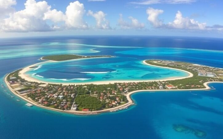
Lost between the Bahamas, Cuba, and Hispaniola, the Turks and Caicos Islands form a small British Overseas Territory whose reputation is built on turquoise waters and picture-postcard beaches. But behind the image of a beach paradise lies a far more complex geography, at the crossroads of the ocean, a dry tropical climate, and extremely fragile ecosystems. A low-lying archipelago resting on coral plateaus, the country lives by the rhythm of the trade winds, dry and wet seasons, hurricanes, and environmental challenges linked to sea-level rise and ocean warming.
An Archipelago on the Edge of the Caribbean
Situated in the North Atlantic, in the northern part of the Lesser Antilles and within the Lucayan Archipelago, the country consists of two distinct groups: the Turks Islands to the east and the Caicos Islands to the west. Politically, it is a British Overseas Territory, separate from the neighboring state of the Bahamas although it belongs to the same geographical extension.
Little Inagua, a Bahamian island, is the closest foreign land, located about 30 kilometers from West Caicos.
The whole is modest in land area but highly fragmented: depending on sources, the land area is around 430 to just over 600 km², for more than 40 islands, cays, and rocks, of which only eight or nine are permanently inhabited.
Two Archipelagos Separated by a Deep Channel
The division between the two groups is clear on maps as it is below the surface: the Turks Islands and the Caicos Islands are cut by the Turks Island Passage, an oceanic channel about twenty nautical miles wide where the depth exceeds 2,200 meters. This blue abyss highlights the contrast with the shallow banks on which the islands rest.
The archipelago is divided into two distinct groups resting on different submarine platforms. The Turks Islands (Grand Turk, Salt Cay, and uninhabited cays) are located on the Turks Bank, a coral plateau of approximately 324 km². The Caicos Islands, on the other hand, occupy the vast Caicos Bank, an oolitic platform whose estimated area generally varies between 4,000 and over 6,000 km².
Further east, beyond the Turks Islands, the Mouchoir Bank extends over nearly 1,000 km² of shallow areas with no emergent land, integrated into the territory’s Exclusive Economic Zone (EEZ). Even further away, Silver Bank and Navidad Bank belong to the Dominican Republic.
Low, Limestone Islands Pitted with Karst
The terrestrial geography rests on a very homogeneous foundation: low, flat islands, composed essentially of marine-origin limestone. These are not volcanoes or mountainous reliefs, but fragments of continental shelf covered over millennia by carbonate deposits produced by marine organisms.
The landscape is typical of emergent coral plateaus: little elevation change, consolidated dunes, very porous soil, and omnipresent karst features. The highest elevations barely reach 48 to 49 meters, at Blue Hills (or Blue Mountain) on Providenciales and at Flamingo Hill on East Caicos. On the scale of an archipelago, these are practically hills.
Due to their low topography and highly fissured limestone bedrock, the Caicos Islands (like North, Middle, and East Caicos) have no rivers. Rainwater quickly infiltrates to feed underground aquifers or flow toward the sea. The dominant aquatic ecosystems are therefore marshes, salt flats, coastal ponds, and mangroves, particularly on the southern coasts of these islands.
Karst features are spectacular in some places. Caves, sinkholes, and cavities are numerous, especially on Middle Caicos, where the Conch Bar Caves system is presented as one of the largest networks of walkable caves in the Caribbean. On Providenciales, cavities like The Hole, and on North Caicos or South Caicos, sites like Cottage Pond or The Boiling Hole, illustrate these landscapes carved by limestone dissolution.
A String of Islands Between Banks, Reefs, and Passes
Beyond the two main names – Turks and Caicos – the geography is organized around a mosaic of main islands, cays, and shallows. The numbers vary according to inventories, but there are about thirty to forty important islands and cays, over a hundred named entities if emergent rocks are included.
The Caicos Islands: The Great Turquoise Plateau
The Caicos constitute the western and largest part of the territory. They all rest on the Caicos Bank, a vast inland sea with depths generally between one and five meters. The substrate here is composed mostly of sands (about two-thirds), supplemented by coral-algal mosaics, proper coral reefs, and some particular habitats.
The archipelago presents a marked contrast between developed and populated islands like Providenciales, and the wilder, uninhabited islands. Providenciales is the tourist and urban center, while North and Middle Caicos are natural islands connected by a causeway. South Caicos retains a fishing tradition, and East and West Caicos remain mostly wild.
Scattered around these larger islands are smaller cays, sometimes occupied by a single resort or left to coastal vegetation: Parrot Cay, Pine Cay, Ambergris Cays, Water Cay, Little Water Cay, French Cay, Dellis Cay, Bush Cay, Seal Cays, Sand Bore Cay, Middle Creek Cay, Plandon Cay, to name just a few.
The Turks Islands: A Smaller Chain, on an Isolated Bank
To the east, the Turks Bank supports a group of islands much smaller in number and area. Two islands are inhabited: Grand Turk, seat of the capital Cockburn Town, and Salt Cay, whose name recalls the history of salt extraction. The others – Big Sand Cay, Cotton Cay, East Cay, Gibbs Cay, Pear Cay, or Endymion Rock – are low cays, sometimes barely emergent, surrounded by reefs.
Grand Turk and Salt Cay are the driest islands in the Turks and Caicos, with sparse vegetation.
Distance, Orientation, and Geographical Extremes
On the scale of the archipelago, the distance between the western tip (West Caicos) and the eastern tip (Martin Pinzon Cay), cited as the easternmost point in some surveys, does not even reach 160 kilometers. It is therefore a compact but fragmented territory, where the coastline (about 389 km) is multiplied by the cuts of reefs, lagoons, and mangroves.
The country lies north of the Tropic of Cancer but well within the tropical zone, bathed by easterly to southeasterly trade winds. Most islands are bordered to the north by the open sea and spectacular drop-offs, and to the south by expanses of turquoise shallows, seagrass beds, and marshes.
A Tropical Savanna Climate: Hot, Dry, and Windy
The country’s climate is classified as “tropical savanna.” In practice, this translates to stable temperatures, lots of sunshine, relative dryness on a Caribbean scale, and the near-total absence of cold in the temperate sense.
The archipelago is often described as the driest part of the greater Bahamian chain. The figure of about 350 days of sunshine per year is sometimes mentioned, which sets the tone: skies rarely overcast for long, intense brightness, very high UV levels, and warm seas year-round.
Temperatures: Permanent Mildness, Without Extremes
The annual average temperatures are around 26 to 27 °C (79 to 81 °F), with a fairly weak seasonal contrast, on the order of 5 °C (9 °F) between the so-called “cool” season and the warm season. From May to October, daytime highs are frequently around 29 to 32 °C (84 to 90 °F), with peaks that can occasionally reach 35 °C (95 °F). From November to April, average highs drop to a range of 27 to 29 °C (81 to 84 °F).
Nighttime lows remain high: it is rare to fall below 17 °C (63 °F), even during incursions of cooler air from North America between December and March. The thermometer may sometimes approach 20 °C (68 °F) or slightly below at night, but never to the point of justifying the term “cold snap.”
Overall, extreme highs rarely exceed 32 °C (90 °F), which, combined with the constant breeze, makes the heat more bearable than in stifling equatorial climates.
Comparative Climate Data
The different available meteorological stations and studies do not all provide the same values, but the orders of magnitude converge. We can summarize a few key indicators as follows.
Seasonal Average Temperatures (Air)
| Approximate Period | Average Low Temp. | Average High Temp. | Comment |
|---|---|---|---|
| “Cool” Season (Nov.–Apr.) | 23–24 °C (73–75 °F) | 27–29 °C (81–84 °F) | Marked breezes, cooler nights |
| Warm Season (May–Oct.) | 26–28 °C (79–82 °F) | 29–32 °C (84–90 °F) | Higher humidity, hurricane risk |
In terms of comfort, this means swimming is possible year-round, that winter evenings only require light clothing, and that the real sensation of heat is concentrated in the summer months, especially sheltered from the wind and away from the coast.
Rare Rain, but Strong Contrasts Between Islands
One of the most marked features of the climate is the low rainfall compared to the rest of the Caribbean. Grand Turk records around 700 to 730 mm (28 to 29 inches) of rain per year, less than many large neighboring islands. General estimates for the archipelago mention averages around 600 to 840 mm (24 to 33 inches) annually, with high spatial variability.
The seasonal distribution in Reunion is characterized by an alternation of wet and dry seasons, but their temporal boundaries vary depending on sources. Some references indicate a rainy season from September to December, while others describe a longer wet period, extending from May to November. The main dry season is generally located approximately from December to April, although some stricter sources define it as January to August.
Rather than daily torrential rains, the islands experience brief showers, concentrated in the late afternoon. Episodes often last less than ten minutes, sometimes a few hours during passages of more active disturbances. Rainfall therefore comes in bursts: a few days of continuous rain several times a year, followed by long dry periods.
Summary of rainfall data established over a decade for the island of Providenciales.
On average, about forty rainy days are recorded per year, which corresponds to a rainy episode every eight to nine days.
The majority of annual precipitation comes from a limited number of events, often associated with tropical waves or cyclones.
Schematic Annual Distribution of Rainfall
| Parameter | Indicative Value |
|---|---|
| Annual Rainfall (Grand Turk) | ~725 mm (≈ 28–29 inches) |
| Average Annual Rainfall (territory) | ~600–840 mm depending on area |
| Wettest Month (Grand Turk) | November (~120 mm / ~4.7 in) |
| Dry Season | Approx. Dec.–Apr. (rare rain) |
| Main Wet Season | Approx. May–Nov., peak Sept.–Nov. |
| Rainy Days/Year (Providenciales) | ~43 days (2006–2016 data) |
Geographical contrasts are striking. The northern and central-western islands – North Caicos, Parrot Cay, Pine Cay, Middle Caicos – are considered the “greenest” and wettest, while Grand Turk and Salt Cay, isolated to the east, are among the driest. Providenciales, South Caicos, and East Caicos occupy an intermediate position, with moderate rainfall.
Flooding, Salt Flats, and Low-Lying Areas
Despite an overall dry regime, flooding can occur, especially in low-lying and impermeable areas. They are mainly linked to intense rains associated with tropical depressions or hurricanes. On Providenciales, some neighborhoods or road areas can be under 30 to 60 cm (12 to 24 inches) of water. In Kew, on North Caicos, cases of stagnation exceeding three meters (10 feet) of water have been reported in topographic depressions, with the water then taking weeks to recede through natural drainage.
The flat terrain and lack of steep relief avoid flash floods and mudslides. The main danger during extreme events is marine flooding, caused by cyclone swell and storm surge, much more than continental runoff.
Scorching Sun, Extreme UV
The abundance of sunshine is one of the country’s tourist assets, but it comes with a very real downside: the intensity of UV radiation. Maximum UV indices regularly reach 12 between April and August, meaning a risk of sunburn in about a quarter of an hour without protection. Even in winter, the index often remains around 7, a level still considered high.
Clouds, when present, filter these radiations poorly, and the combination of breeze and seawater tends to mask the onset of erythema (sunburn). From a strictly geographical point of view, this underscores the central role of the sun in the functioning of ecosystems (seagrass productivity, warming of the flats, intense evaporation) as in daily life.
A Sea Warm Twelve Months a Year
Sea surface temperature varies less than the air but remains particularly pleasant. In winter, the sea drops to around 25–26 °C (77–79 °F), even 23–24 °C (73–75 °F) in the most exposed offshore areas, while in summer it rises to 28–29 °C (82–84 °F), with a maximum around 29 °C (84 °F) between August and October. The annual average is close to 27–28 °C (81–82 °F).
Shallow, sheltered bays like Sapodilla Bay or Taylor Bay can be noticeably warmer than coasts fully exposed to the oceanic flow, for example at Grace Bay. Conversely, divers who move away from the fringing reefs to follow the drop-offs feel slightly cooler water.
A Territory Surrounded by Reefs and Coral Banks
One of the major characteristics of the country’s geography is its anchorage on immense coral platforms and the presence of a reef system among the most extensive in the tropical Atlantic. The northern fringes of the large islands are bordered by fringing reefs, about a kilometer from the shore, which drop abruptly into deep water.
A Coral Barrier of Regional Scale
Estimates vary, but the territory’s coral reefs cover about 1,200 km² and are part of what is often described as the third-largest coral system in the world. The reefs form a veritable natural barrier against swells and storm surges, protecting beaches, mangroves, and coastal lowlands.
The fringing reefs north of Providenciales, Grand Turk, or some Caicos Islands are characterized by a drop-off usually starting between 14 and 18 meters (46-59 ft) deep, then plunging vertically into abysses exceeding 2,000 meters (6,560 ft). This “wall” topography makes the archipelago a renowned site for “wall diving,” appreciated for the spectacular verticality of its drop-offs and the abundance of marine life.
Scientific surveys conducted in the late 1990s on the reefs of Grand Turk highlighted a high diversity, with more than thirty species of hard corals recorded and coral cover rates sometimes exceeding 30 or 40% on some studied sites. More recently, monitoring has shown the resilience of several key species despite global bleaching episodes between 2014 and 2017.
Composition of the Submarine Banks
The major banks – Caicos Bank, Turks Bank, and Mouchoir Bank – each have their own geomorphological signature, but all rest on mixtures of carbonate sand, seagrass, coral, and calcareous algae.
Indicative Composition of Substrates
| Platform | Sand | Coral + Algae | Coral Reefs | Other Habitats |
|---|---|---|---|---|
| Caicos Bank | ~64 % | ~18 % | ~7 % | ~11 % |
| Turks Bank | ~43 % | ~29 % | ~26 % | ~3 % |
| Mouchoir Bank | – | – | – | Coral + sand (overall data) |
These percentages, from detailed benthic mapping, show the dominance of sand on the Caicos Bank, which translates on the surface into vast shallow turquoise expanses, dotted with coral heads and seagrass beds.
Protected Areas and Marine Reserves
Faced with the richness of these environments, the country has established a significant network of protected areas: about a dozen national parks, as many nature reserves, and several sanctuaries, mostly marine-dominated. Among the best known are Princess Alexandra National Park (which encompasses much of the Grace Bay shoreline and its reefs), Chalk Sound National Park, Northwest Point Marine National Park, West Caicos Marine National Park, and the Ramsar wetland complex of North, Middle, and East Caicos.
Specialized reserves also exist, such as the East Harbour Lobster and Conch Reserve near South Caicos, focused on protecting lobster and conch stocks, two key fishery resources of the territory.
Rare Terrestrial Ecosystems and a Biodiversity Hotspot
On land, the geography conditions a series of island ecosystems that make the country a true biodiversity hotspot. Three major terrestrial ecoregions have been identified: Bahamian dry forests, Bahamian pine forests, and Bahamian-Antillean mangroves.
The vegetation is diverse, ranging from coastal scrub to savannas, through dry thickets, Caicos pine woodlands (national tree), mangroves, marshes, and cactus areas. Low rainfall, saline soils, and absence of deep soil have shaped a flora resistant to drought and salt, including many endemic species.
Among the emblematic species are the Turks and Caicos rock iguana, certain dwarf boas, barking geckos, and a multitude of unique plants, like the territory’s endemic heather. Lagoons and salt flats host important seabird colonies and serve as stopovers for many migratory species.
A Human Geography Concentrated on a Few Islands
While the physical geography unfolds over dozens of islands, the human geography is much more concentrated. The vast majority of the population lives on Providenciales, followed by Grand Turk. The other inhabited islands – North Caicos, Middle Caicos, South Caicos, Parrot Cay, Pine Cay, Ambergris Cays, and Salt Cay – have much smaller populations.
Recent censuses and estimates report just under 60,000 inhabitants for the entire territory of the Turks and Caicos Islands.
Urbanization is concentrated mainly along the northern fringe of Providenciales (Grace Bay, Leeward, The Bight, Downtown, Five Cays), as well as in Cockburn Town on Grand Turk. The south of the large islands, more marshy and difficult to access, remains largely preserved.
Infrastructure and Spatial Organization
The archipelago is structured around a few key infrastructures that reveal the geography of flows. Providenciales International Airport (PLS) serves as the main international gateway. Other runways – JAGS McCartney International Airport on Grand Turk, Norman B. Saunders Sr. International Airport on South Caicos, Clifford Gardiner on North Caicos, as well as airstrips on Middle Caicos, Salt Cay, Pine Cay, or Ambergris Cay – ensure domestic service and some regional flights.
The road network of the Turks and Caicos Islands extends about 120 kilometers, mostly unpaved.
The main ports are located at Grand Turk, Providenciales, and South Caicos, the latter still playing a central role for fishing today. There are no modern railways; the only historical example remains an old horse-drawn railway on East Caicos, a vestige of the sisal era.
Sea, Fishing, and Economy: Geography at the Heart of Daily Life
The country’s economy rests on three pillars that its geography directly conditions: beach tourism, offshore finance, and marine resources. The shallow banks, rich reefs, and clear waters make the territory a major destination for diving, sport fishing, and high-end vacationing. The white sand beaches – about 332 km² of beachfront – constitute a unique landscape capital.
Over one million pounds of conch were landed annually in the late 1990s in the Turks and Caicos Islands.
Multi-species spawning grounds, like the one identified off East Caicos, underscore how the submarine topography – passes, bank edges, drop-offs – structures reproductive cycles and, consequently, resource sustainability.
Hurricanes, Sea-Level Rise, and Pressures on a Low-Lying Territory
Being a low-lying archipelago in the heart of the tropics has a price: exposure to tropical cyclones and the consequences of climate change. The archipelago is located right in the corridor of the Atlantic hurricane season, which officially extends from early June to late November, with a peak risk between August and October.
Cyclone Risk and Physical Vulnerability
Direct hits by major cyclones remain relatively rare on a statistical scale, but several significant category storms have struck or severely affected the territory in recent decades. They bring intense precipitation, storm-force winds, and above all a storm surge capable of submerging entire portions of banks and coastal plains.
In a country with very low relief, where many zones and infrastructure are coastal, storm surge is a more serious threat than rain. The degradation of reefs and mangroves, natural buffers, by human activity or disease, reduces this crucial protection.
Climate Change and Environment
Beyond cyclones, the gradual rise in sea surface temperatures and ocean acidification weigh on the coral reefs. Mass bleaching episodes, like those recorded in the mid-2010s linked to marked El Niño events, have weakened large portions of reefs. An emerging disease, Stony Coral Tissue Loss Disease (SCTLD), first appearing in Florida and then reported in the country’s waters in the late 2010s, has accelerated this weakening, successively affecting South Caicos, West Caicos, Northwest Point, Grace Bay, Pine Cay, Middle and North Caicos, all the way to Grand Turk.
In territories characterized by shallow banks, fringing reefs, and an absence of relief, vulnerability to climate risks (sea-level rise, more intense storms, ecological disturbances) is amplified. Implementing energy resilience projects, adapted spatial planning, and expanding marine protected areas are therefore essential responses, dictated as much by geographical necessity as by environmental logic.
A Geography That Shapes Tourist Seasons
The perception of climate and geography is not limited to meteorological figures: it also translates into the tourist calendar. The so-called “cool” season, from December to April, corresponds to the most popular months for beach stays: very sunny weather, rare rain, pleasant temperatures, low cyclone activity. December and January often concentrate the highest arrivals, with high rates.
The months of September and October are the low season. They offer a sea that is still pleasant and reduced crowds, freeing up space on beaches and dive sites. However, this period combines higher humidity, maximum hurricane risk, and the closure of some services for renovation.
Specific activities, like whale watching, are also aligned with the geographical calendar of migrations: humpback whales frequent the deep waters of the Turks Island Passage and the edges of the banks mainly in winter and early spring. For their part, diving enthusiasts often prefer late summer and autumn for maximum underwater visibility, although this coincides with the hurricane season.
A Map in Perpetual Negotiation Between Sea, Wind, and People
Ultimately, the geography of the Turks and Caicos Islands is the story of a delicate balance between an omnipresent sea, fragile land, and a climate that is both favorable and formidable. An archipelago of limestone resting on turquoise banks, a dry territory in the midst of the tropics, a mosaic of low islands open to the trade winds, it concentrates many geographical paradoxes.
The scarcity of freshwater resources, the absence of relief, the dependence on coral reefs for coastal protection, the importance of banks for fishing and navigation, the demographic concentration on a few islands, the exposure to hurricanes and sea-level rise: everything here refers back to a geography that imposes its constraints as much as it offers its assets.
In the islands, the border between land and sea is fluctuating. The ocean level conditions habitability and the landscape is continuously redrawn with cyclone seasons, sediment movement, the state of coral reefs, and the evolution of mangroves. Thus, any development decision (road, pass, hotel, fishing zone) has repercussions far beyond the concerned plot.
It is this permanent tension between apparent fixity and continuous transformation that makes the geography of the Turks and Caicos Islands much more than a beach backdrop: a living laboratory of the interactions between ocean, climate, and island society.
Disclaimer: The information provided on this website is for informational purposes only and does not constitute financial, legal, or professional advice. We encourage you to consult qualified experts before making any investment, real estate, or expatriation decisions. Although we strive to maintain up-to-date and accurate information, we do not guarantee the completeness, accuracy, or timeliness of the proposed content. As investment and expatriation involve risks, we disclaim any liability for potential losses or damages arising from the use of this site. Your use of this site confirms your acceptance of these terms and your understanding of the associated risks.

Cyril Jarnias is an independent expert in international wealth management with over 20 years of experience. As an expatriate himself, he is dedicated to helping individuals and business leaders build, protect, and pass on their wealth with complete peace of mind.
On his website, cyriljarnias.com, he shares his expertise on international real estate, offshore company formation, and expatriation.
Thanks to his expertise, he offers sound advice to optimize his clients' wealth management. Cyril Jarnias is also recognized for his appearances in many prestigious media outlets such as BFM Business, les Français de l’étranger, Le Figaro, Les Echos, and Mieux vivre votre argent, where he shares his knowledge and know-how in wealth management.





