
 Published on and written by Cyril Jarnias
Taking public transportation in Lebanon can feel like jumping into the deep end without knowing how to swim. Yet the country has a dense and inexpensive network that connects most cities in a few hours. But between recently revived public buses, private minibuses with no official schedules, shared “service” taxis, and mobile apps, the system is anything but clear at first glance.
This practical guide provides factual information, concrete benchmarks, and on-the-ground tips to help you get around Lebanon without a car.
Understanding Lebanon’s Transportation Landscape
Lebanon has long operated without a truly integrated public transportation system. After the civil war, private cars dominated, rails rusted, and public buses fell into disrepair. Today, the country is in a paradoxical situation: it has no subway, no trains, and no “conventional” national bus network, but it has a myriad of formal and informal options that, pieced together, form a relatively complete system.
Lebanon’s road network, essential for travel, spans over 8,000 kilometers.
Within this landscape, a major new development is gradually changing the game: the revival of a structured public bus network with numbered lines (B1 to B7, ML1 to ML4), operated under a public-private partnership.
The New Public Bus Network: What You Need to Know
Since 2024, a new public bus system has been redefining mobility in Beirut and beyond. It is jointly managed by the Railway and Public Transport Authority (OCFTC), the public authority, and a private company, Ahdab Commuting and Trading Company (ACTC), which won a tender from the Ministry of Public Works and Transport.
The stated goal is clear: to structure, for the first time, a readable network with schedules, identified lines, standardized fares, and modern digital tools, while coexisting with private minibuses.
A Network Still Being Rolled Out
Ultimately, the network is planned to include 11 lines: 7 urban “B” lines covering Greater Beirut and 4 “ML” lines (for “main lines”) connecting the capital to major coastal and inland cities.
In practice, only 7 lines are officially active, and as of the latest information, only lines B1, B2, B3, and ML3 are actually running regularly. Some lines like B1, B3, and ML3 are split into two routes depending on direction (outbound/return), which explains why there are sometimes two slightly different itineraries under the same code.
The principle remains simple: “B” lines serve the main neighborhoods of Beirut and its suburbs, while “ML” lines provide major connections to the north, south, and mountains.
Major Urban Lines (B1 to B7)
The B lines are designed as an urban backbone connecting the capital’s main hubs: Dora, Nahr El Mot, Hamra, Raouché, Sassine, Cola, Martyrs’ Square, Hadath, etc.
Here is an overview of the routes, useful for getting around the city.
| Line | Main Points Served | Type |
|---|---|---|
| B1 | Nahr El Mot – Dora – Ain El Mreisseh – AUB Seaside – UNESCO – Cola – Barbir – Adlieh – back to Nahr El Mot | Coastal/downtown loop |
| B2 | Nahr El Mot – Dora – Adlieh – Cola – UNESCO – Raouché – AUB Seaside – 4 Seasons – Dora – Nahr El Mot | Northwest axis via Corniche |
| B3 | Antelias – Jal El Dib – Zalka – Dora – Mar Mikhael – Sassine – Bechara El Khoury – Basta – Mar Elias – Bristol | Northeast / central neighborhoods |
| B4 | Martyrs’ Square – Beirut Souks – Hamra – Sanayeh – Bchara Khoury – Qasqas – Tayouneh – Moucharrafieh – Laylaki – Lebanese University | East–west center–south |
| B5 | Nahr El Mot – Jdeideh – Jesr Achrafieh – Sassine – Sodeco – Basta – Druze Council – Concord – Nahr El Mot | East–center loop |
| B6 | Martyrs’ Square – Beirut Souks – Cola – Ouzai – Khalde – Damour – Martyrs’ Square | Southern coastal axis |
| B7 | Mar Mikhael Station – Adlieh – LU Hadath – Saida Old Road – Khalde – back to Mar Mikhael | Southern periphery / university |
Even though not all are fully operational yet, this grid helps understand the logic of the network: to connect residential neighborhoods, university hubs (Hadath, Lebanese University), commercial areas (Hamra, Beirut Souks), and major city entry/exit points (Dora, Khalde, Damour).
Intercity Lines (ML1 to ML4)
The ML lines extend this network beyond the capital.
| Line | Main Route | Destination |
|---|---|---|
| ML1 | Adlieh – Hazmieh – Kahaleh – Aley – Bhamdoun – Sawfar – Chtaura | To the Beqaa via the mountains |
| ML2 | Khalde – Damour – Jiyeh – Jadra – Saida – Ghazieh – Sour (Tyre) | To the southern coast |
| ML3 | Dora – Bourj Hammoud – Nabaa – Saloumi – Habtour – Chevrolet – Gallery Semaan – Hadath – Antonine University – Baabda Hospital | East/southeast suburban axis |
| ML4 | National Museum – Nahr El Mot – Antelias – Jounieh – Byblos – Batroun – Chekka – Tripoli | Major northern coastal axis |
In practice, ML4 is the one to know if you want to reach Jounieh, Byblos/Jbeil, Batroun, or Tripoli by a structured bus rather than an informal minibus. ML2 plays a similar role towards Saida and Tyre, while ML1 is the main gateway to the Beqaa (Chtaura, then Zahle, Baalbek, etc., via other connections).
Schedules, Frequency, and Operation
Public buses follow, for the first time, relatively clear time windows. Officially:
Buses run every day from about 6 a.m. to 7 p.m. During Ramadan, service ends earlier, around 5 p.m. The average announced frequency is 20 to 25 minutes, but it can vary depending on traffic.
Lebanon is notoriously congested, especially in Greater Beirut, so it’s best to allow plenty of extra time: the same distance can take 10 minutes or 40 minutes during rush hour.
A Modernized Bus Fleet
The new network relies on approximately 95 to 100 vehicles in operation. About fifty buses were donated by France, and the rest were refurbished by OCFTC and ACTC. All are repainted in an easily identifiable dark blue and equipped with GPS, air conditioning, modern ticketing systems, and real-time tracking.
Important distinction: These buses are among the first public transport vehicles in Lebanon that are truly accessible to people with reduced mobility. In a country where the vast majority of buses and taxis remain unsuitable, this represents a significant step forward.
Meanwhile, hybrid buses are already running in Zahlé, and the first 100% electric buses, powered by a solar charging system, are expected to connect Beirut to Jbeil.
Fares, Payment, and New Transport Cards
One of the advantages of the recent public system is the clarity of its fares. No more, in theory, haggling every time you board.
Fares for ACTC/OCFTC Public Lines
Prices are standardized per trip, with one notable exception:
| Trip Type | Fare in LBP | Notes |
|---|---|---|
| Standard trip (B1, B2, B3, B4, B5, B6, B7, ML1, ML2, ML4) | 70,000 LBP | Flat fare per boarding |
| ML3 trip | 100,000 LBP | Longer / suburban line |
| Rechargeable card (purchase price) | 250,000 LBP | Includes a first validation worth 70,000 LBP |
In practice, for most urban and intercity lines, you pay 70,000 LBP per trip. ML3 is slightly more expensive due to its length.
How to Pay on Public Buses
There are two main options:
– pay in cash to the driver when boarding
– use a rechargeable card
If you pay in cash, the driver gives you a ticket with a QR code to scan. Although the system is still very cash-oriented, the logic is gradually shifting toward digital supports.
The rechargeable card, sold for 250,000 LBP, includes an initial credit covering one trip at 70,000 LBP. It can then be topped up at a network of partner points mainly in Beirut and its close suburbs (phone shops, mini-markets, etc.). Possible locations include the main Katsh office at Starco (Minet El Hosn), several “Cell” shops in Hamra or Bourj Hammoud, and services in Dora, Hadath, or Manara.
Several means are available to find a top-up point or get information.
Dial 70 600 026 or 70 600 036 to locate the nearest top-up point.
Contact the information line at +961 3 114 664 or +961 24 543 869 for any questions.
Follow the dedicated Instagram account for the latest news and information.
The New Official Countrywide Fare Scale
Beyond the ACTC/OCFTC network, the Ministry of Public Works and Transport has set an official scale covering private taxis, “service” taxis, minivans, and buses. These fares serve as a reference for the entire sector, formal and informal.
Here is an overview of official prices within Beirut and to some major destinations, in Lebanese pounds:
| Route | Private Taxi | “Service” Taxi (shared) | Bus / Minibus |
|---|---|---|---|
| Within Beirut | 600,000 LBP | 150,000 LBP | 75,000 LBP |
| Beirut – Saida | 1,200,000 | 300,000 | 150,000 |
| Beirut – Sour (Tyre) | 2,280,000 | 570,000 | 270,000 |
| Beirut – Tripoli | 2,400,000 | 600,000 | 240,000 |
| Beirut – Jounieh | 600,000 | 150,000 | 90,000 |
| Beirut – Jbeil (Byblos) | 1,080,000 | 270,000 | 150,000 |
| Beirut – Aley | 720,000 | 180,000 | 90,000 |
| Beirut – Baalbek | 2,400,000 | 600,000 | 285,000 |
These amounts give a ballpark figure to avoid being overcharged, even if, in practice, some drivers still negotiate – especially with foreigners. Inflation and the fluctuating exchange rate also complicate things, but this scale at least lets you know what range to discuss in.
Major Bus Hubs: Where to Go to Get Going
To understand transportation in Lebanon, you need to know three names: Charles Helou, Dora, and Cola. These nodes structure most intercity lines.
Charles Helou: Gateway to the North and Syria
Located between the port and Gemmayzé, the Charles Helou bus station is the main platform for northern destinations and for buses to Damascus and other major Syrian cities. It is easily reachable on foot from downtown via Saifi Urban Gardens.
The station is organized into zones (A, B, C) with ticket counters. Buses to Jounieh, Byblos, Batroun, and Tripoli usually depart from zone C and almost all pass through the Dora roundabout. The Connexion company operates reputedly frequent and organized services there, with departures every 15 to 20 minutes heading north.
Dora (Dawra): Major Crossroads for the North and Mountains
The Dora roundabout, east of Beirut, is a massive road interchange that serves as a departure point for most buses and minibuses to northern cities and mountain villages. From here, vehicles head to Byblos, Jounieh, Batroun, Beit Mery, Broummana, as well as Tripoli or the Kadisha Valley via minivans.
From Dora, the main drop-off point for buses coming from the north, you can reach different neighborhoods of Beirut by taking a minibus or urban bus. Lines 6 and 15 serve Cola, line 2 goes to Achrafieh and Hamra, and other lines go to Charles Helou.
Cola: To the South and the Beqaa
The Cola intersection, southeast of downtown Beirut, is the other major intercity hub. It is from here that most buses and minibuses depart for:
– the south (Chouf region, Saida, Sour/Tyre)
– the Beqaa (Chtaura, Zahle, Baalbek)
Cola looks more like a lively parking lot with rows of minibuses than a formal bus station. The principle is simple: vehicles wait to fill up before heading in the direction announced by the drivers.
Private Buses, Minibuses, and the Informal Network: The Real “Backbone” of the System
While the new public network gets a lot of attention, the daily life of Lebanese people still relies heavily on an informal system of minibuses and private “vans”. It is estimated that there are about 3,500 private medium-sized buses and 4,000 minibuses/small vans, in addition to thousands of taxis.
How Minibuses/Microbuses Work
In most cities and on major intercity routes, small minibuses – often blue, red, or white – ply the roads on more or less fixed routes. There are generally no marked stops or posted schedules. To get on, you stand by the side of the road and wave at the driver, just like a taxi.
The driver sometimes announces the destination, and passengers only board if it matches theirs. The vehicle usually leaves once it’s nearly full, which may involve a short wait at the start but allows for a direct and faster trip afterward.
Fares are in principle fixed per segment, but since nothing is posted, it is safer to ask another passenger or prepare small bills and watch what locals pay. Historically, prices for short urban trips ranged between 1,000 and 7,000 LBP; with the economic crisis and the new fare grid, LBP amounts have risen sharply but remain, in dollar terms, very cheap.
Private LCC Buses and Other Companies
The Lebanese Commuting Company (LCC), often associated with red buses in Greater Beirut, operates its own network of about a dozen lines, sometimes reaching as far as Jbeil, Broummana, or Aley. These bus fares were once around 1,000 to 5,000 LBP depending on distance; they have logically followed the devaluation of the pound.
The network suffers from the lack of an official map, unclear line signs, unpublished schedules, and erratic punctuality. These buses are often recommended for budget travelers, but not for those with tight time constraints.
A Network Without a Map… But With Collaborative Maps
Officially, there is no printed map or comprehensive online map of bus and minibus lines. Into this void, citizen initiatives have emerged. The best known is The Bus Map Project, which attempts to map routes, especially in Beirut, based on user contributions. Their site BusMap.me and Facebook page share useful information on routes and prices.
Additionally, the OpenStreetMap community has gradually integrated bus and minibus lines; the Beirut transport map on OSM is considered one of the most reliable for orientation. It is a good complement to official apps.
“Service” Taxis and Private Taxis: How They Work
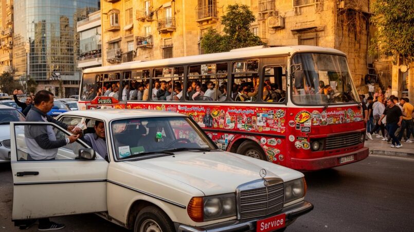
For many Lebanese, daily transportation comes mainly from taxis – especially the famous “service”, a local institution that is as practical as it is confusing for a visitor.
Identifying Official Taxis
Taxis authorized for public transport are identified by their red license plates. They can operate in two modes:
– service (shared taxi on a common route)
– private taxi (exclusive trip)
In both cases, the golden rule is the same: meters are rarely used. So you must agree on the price before getting in, or at least know the ballpark fares to avoid unpleasant surprises.
The “Service”: The Most Economical Option
The service operates like a shared taxi on common routes. The driver picks up passengers heading in the same direction, up to 4 or 5 people, and drops them off along the way, on main streets and squares.
The new official scale sets the fare for an intra-Beirut taxi service at 150,000 Lebanese pounds.
The logic remains the same:
In Kinshasa, to use a shared taxi, you have to stand on the correct side of the street, in the direction you want to go. You hail the vehicle like a regular taxi and tell the driver your destination. The driver accepts or refuses based on their planned route and the number of available seats. Payment is usually made upon exiting, directly to the driver.
On slightly longer distances, some passengers voluntarily offer a “double service” to ensure they are taken, paying the equivalent of two seats.
Private Taxis: Comfort and Negotiation
Private taxis, whether hailed on the street or called by phone, offer an exclusive ride. They are more expensive than services but remain relatively affordable. The official internal scale within Beirut shows 600,000 LBP for a standard trip, a few dollars.
Without a meter, negotiation is the norm. The trick is to know the official price or what locals pay and firmly but politely state the amount you are willing to pay, even before opening the door.
Mobile Apps and Digital Tools: Your Best Allies
In such an informal environment, digital tools play a key role in bringing clarity to the system.
The ACTC PT / ACTC PTC App
The public network has its own app, ACTC PT (the name varies slightly depending on the source), which allows you to:
– track buses in real time via GPS
– plan a trip by line or region
– locate the nearest stops
– view estimated arrival times
– check fares and any alerts
The app is available in Arabic and English. It uses artificial intelligence and geolocation to improve passenger information. It is the ideal tool for understanding how the B and ML lines work without knowing Arabic.
Other Public Transit Apps
Several other tools complete the picture:
– BusMap لبنان : an app from the Bus Map Project, offering information on bus lines and minibuses throughout the country
– Peep : an app developed by students, with live tracking of some buses, route exploration, and safety features, especially for women
– myStop Mobile : a real-time tracking app linked to a “Lebanon Transit” service (more focused on a specific system than the national network)
Google Maps, Waze, and Maps.me are useful for visualizing traffic, main axes, and offline navigation. However, Google Maps does not integrate Lebanese bus lines well and cannot replace specialized transit apps.
Ride-Hailing and Digital Taxi Options
In the taxi market, ride-hailing apps like Uber, Careem, Bolt, and TaxiF have become established in Beirut and its surroundings. They offer three major advantages:
– price displayed before departure
– real-time trip tracking
– card or cash payment options, with trip history
They remain more expensive than a service, but often less than a traditional private taxi negotiated blindly. Innovative local apps, like SERVICE App, go further by digitizing the very concept of service (shared or private mode, tracking, SOS button), or Heya Ride, dedicated to women, which connects female passengers with female drivers.
Safety, Comfort, and Vulnerable Groups
Overall, Lebanon is described as a relatively safe country for travel, including for solo women, but the transport system is not without risks, especially at night or in certain shared taxis.
Recommendations from embassies and security authorities suggest avoiding haphazardly hailed services after dark and preferring:
– taxis from recognized companies
– ride-hailing services booked through an app
– identified public buses (ACTC/OCFTC network)
For wheelchair users, the majority of buses, minibuses, and taxis are not adapted. Although improvements exist (accessible public buses, ramps in some recent locations) and private services like Able Taxi offer solutions, their cost is high and getting around remains a major challenge.
Practical Tips for Using Public Transportation in Lebanon
Navigating this system takes a bit of preparation and a lot of flexibility.
On buses and minibuses, it is useful to:
– always keep small denominations in LBP, as drivers rarely have change
– sit toward the front to avoid being squeezed during rush hour
– tell the driver in advance where you want to get off
– accept that a departure may be delayed while the vehicle fills up
On the B and ML lines, the ACTC PT app reduces uncertainty about departures and clearly identifies stops. An official network map has also been published, a major novelty in a country where line maps previously did not exist.
For more complex trips – for example, reaching Jeita Grotto, Our Lady of Lebanon in Harissa, or mountain villages – you often need to combine:
– a bus or minibus to the nearest town (Jounieh, Jbeil, etc.)
– a private taxi or local service for the last few kilometers
In Greater Beirut, a typical car-free day might alternate walking (Beirut city center, Corniche, Hamra are quite walkable), service for short hops between neighborhoods, ride-hailing for late trips or to the airport, and public buses to connect Dora, Cola, Nahr El Mot, Hadath, or the main exits to the north and south.
Why Public Transportation Matters More Than Ever
Behind the practical question “how to take the bus?” lies a broader issue. Lebanon faces a deep mobility crisis: more than 650,000 vehicles enter Greater Beirut every day, transport-related pollution puts the country among the top per capita emitters in the Levant, and the skyrocketing price of fuel has made private cars inaccessible to a large part of the population.
The cost of transportation increased by more than 500% after the removal of fuel subsidies in Lebanon.
It is in this context that the revival of a structured public bus network, supported by real-time apps, modern buses (including electric ones), and standardized pricing, takes on strategic importance. For now, coverage remains partial, lines are still limited, and coexistence with the informal sector is sometimes tense – some private operators have even threatened or vandalized public buses, fearing for their income.
Despite these obstacles, the increase in passenger numbers – from a few hundred at launch to several thousand per day, with peaks around 7,000 daily users on the new network – shows that there is a real demand for reliable public transport.
In Summary: How to Find Your Way When You Arrive in Lebanon
For a traveler or a new arrival, the easiest approach is to see public transportation in Lebanon as an assembly of complementary layers rather than a fully integrated network.
For major intercity routes (e.g., Beirut-Tripoli), prioritize public ML buses or established minibuses from Charles Helou and Cola stations. For Beirut and its suburbs, combine B bus lines (B1, B2, B3), services (shared taxis), and walking: public buses are slower but safer and air-conditioned, while services are more direct but require understanding the system. For nighttime travel, turn to ride-hailing (Bolt, Uber, Careem) or taxis from recognized companies for greater safety and convenience. On a tight budget, use public options at 70,000–100,000 LBP, then services at official rates, avoiding private taxis without prior negotiation. To stay informed, download the ACTC PT app, check BusMap.me and OpenStreetMap, use Waze or Google Maps for traffic, and don’t hesitate to ask locals, who remain the best source of information in a system that is still very oral.
Public transportation in Lebanon does not resemble that of major European cities: here, no subway, few marked stops, and often theoretical schedules. But with a little preparation, a charged phone, and a taste for improvisation, it is entirely possible to cross the country from end to end in a few hours, from Beirut to Tripoli, from Saida to Baalbek, discovering along the way an essential part of daily Lebanese life.
Disclaimer: The information provided on this website is for informational purposes only and does not constitute financial, legal, or professional advice. We encourage you to consult qualified experts before making any investment, real estate, or expatriation decisions. Although we strive to maintain up-to-date and accurate information, we do not guarantee the completeness, accuracy, or timeliness of the proposed content. As investment and expatriation involve risks, we disclaim any liability for potential losses or damages arising from the use of this site. Your use of this site confirms your acceptance of these terms and your understanding of the associated risks.

Cyril Jarnias is an independent expert in international wealth management with over 20 years of experience. As an expatriate himself, he is dedicated to helping individuals and business leaders build, protect, and pass on their wealth with complete peace of mind.
On his website, cyriljarnias.com, he shares his expertise on international real estate, offshore company formation, and expatriation.
Thanks to his expertise, he offers sound advice to optimize his clients' wealth management. Cyril Jarnias is also recognized for his appearances in many prestigious media outlets such as BFM Business, les Français de l’étranger, Le Figaro, Les Echos, and Mieux vivre votre argent, where he shares his knowledge and know-how in wealth management.





