
 Published on and written by Cyril Jarnias
Nestled in the south of the Lesser Antilles arc, at the boundary between the Atlantic Ocean and the Caribbean Sea, the Geography of Saint Vincent and the Grenadines is that of a small island state, but a vast maritime territory. Across 389 km² of emerged land, the archipelago displays a mosaic of volcanic islands, low cays, mountains covered in tropical rainforest, coral reefs, and beaches with contrasting sands—black on the main island and white in the Grenadines. This ensemble, situated south of the main Atlantic hurricane development zone, lives to the rhythm of a warm, humid tropical maritime climate, increasingly under pressure from climate change.
A Small State, a Vast Maritime Space
The Geography of Saint Vincent and the Grenadines begins with an obvious fact: the sea dominates everything. The country has no land borders, but claims an exclusive economic zone of 200 nautical miles, or more than 36,000 km², almost one hundred times the area of its islands.
The archipelago consists of the main island of Saint Vincent in the north and the northern two-thirds of the Grenadines chain in the south, comprising 32 islands and cays under its jurisdiction. The southern third of the Grenadines belongs to Grenada, making the line between Petit Saint Vincent and Petit Martinique a strategic maritime border. Some counts include over a hundred micro-islets and rocks.
Position and Regional Neighbors
The archipelago’s coordinates revolve around 13°15′ north latitude and 61°12′ west longitude. It is located:
– south of Saint Lucia,
– north of Grenada,
– west of Barbados,
– at the southeastern tip of the Caribbean Sea, where it meets the Atlantic.
The geographical proximity to neighbors explains dense maritime and air exchanges, but also a shared exposure to the same climatic and geological risks.
Relative Size in the Lesser Antilles
With its 389 km², the Geography of Saint Vincent and the Grenadines places the archipelago in the category of micro-states, but it remains larger than Barbados and slightly larger than Grenada. The main island, Saint Vincent, concentrates most of the area (approximately 344 km²), while all the Grenadines controlled by the country represent only about 45 km².
| Territorial Indicator | Approximate Value |
|---|---|
| Total country area | 389 km² |
| Saint Vincent area | 342–344 km² |
| Grenadines area (SVG portion) | 43–45 km² |
| Length of Grenadines chain (SVG) | ~60 km |
| Total coastline length | 264 km |
| Size comparison | ≈ 2× Washington D.C. |
This contrast between small emerged lands and a vast maritime space shapes the state’s priority given to coastal policies, fisheries management, and reef protection.
Saint Vincent: A Volcanic and Mountainous Island
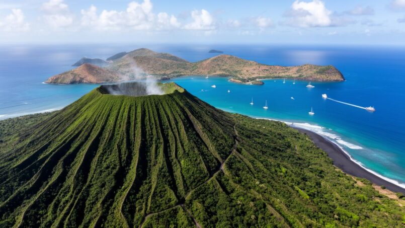
At the heart of the Geography of Saint Vincent and the Grenadines, Saint Vincent is a rugged volcanic island. A chain of forested mountains runs roughly north to south, leaving only limited coastal plains. The steep terrain long served as a natural rampart, complicating European colonization until the early 18th century and still limiting large-scale mechanized farming today.
La Soufrière, Summit and Threat
The country’s highest point, the La Soufrière volcano dominates the island with an elevation of approximately 1,234 meters. It is an active stratovolcano with a marked eruptive past: explosions in the 19th and early 20th centuries, reawakening in 1979, then a new eruptive phase in 2020–2021, with major explosions in April 2021. These episodes triggered massive evacuations (up to nearly 20,000 people), destroyed some of the most fertile agricultural lands in the north of the island, and covered a large part of the territory in ash.
The volcano of Saint Vincent, through its periodic eruptions, illustrates the duality of the country’s geography. On one hand, its ash enriches soils and creates fertile terrain, favoring agriculture. On the other, it exposes the population and territory to extreme natural hazards, shaping a landscape constantly reshaped between benefits and threats.
Among other summits are Richmond Peak, Mount Brisbane, Colonarie Mountain, Grand Bonhomme, Petit Bonhomme, and Mount St Andrew, all landforms that structure watersheds and block clouds, amplifying rainfall on the central axis.
Slopes, Coasts, and Contrasting Sands
The terrain dictates the shape of the shores. The windward side, to the east, exposed to the trade winds, is particularly steep, rocky, and battered by Atlantic swell. The leeward western coast, facing the Caribbean Sea, offers more sheltered bays, with beaches, deep inlets like Wallilabou or Cumberland, which serve as nautical anchorages.
This is the percentage of Saint Vincent’s beaches with black sand, a color due to the volcanic origin of the materials.
Short Rivers and Erosion
The mountains intercept moisture but the narrow terrain does not allow for large rivers to form. The island is crisscrossed by numerous short, fast-flowing watercourses, all non-navigable. They swell suddenly during intense rains, causing flash floods, landslides, and a massive influx of sediment towards the coast.
The Rabacca, on the eastern flank, is one of the most well-known. Overall, the island has estimated renewable water resources of about 100 million m³, exploited for potable water supply and hydroelectricity (notably at South Rivers, where a VINLEC power plant operates).
This erosion dynamic is accentuated by deforestation and slope cultivation: fewer forests mean increased surface runoff, more sediment in the rivers, and ultimately coral reefs smothered by deposits.
The Grenadines: An Archipelago of Reefs and Lagoons
South of Saint Vincent, the Geography of Saint Vincent and the Grenadines changes scale and tone. The Grenadines chain consists of small islands and cays, lower and often less rugged than the main island, encircled by reefs and turquoise lagoons. Bequia, Mustique, Canouan, Mayreau, Union Island, Palm Island, Petit Saint Vincent, Young Island… names associated with postcard-perfect white sand and yacht anchorages.
Morphology and Marine Environments
The Grenadines occupy a portion of the Grenadine Bank, a vast shallow platform averaging about 50 meters deep, which drops off abruptly towards the open sea into the Tobago Trough. This platform hosts one of the most extensive coral assemblages in the Lesser Antilles: fringing reefs along the coasts, barrier reefs protecting lagoons, seagrass beds, and mangroves in some sheltered coves.
The Tobago Cays, five small islets surrounded by reefs east of Mayreau, form an emblematic marine park. Their exceptionally clear lagoon is home to green turtles and rich corals, including the important Elkhorn coral. This site is a showcase of local marine biodiversity, but it remains fragile, threatened by repeated anchorings, trampling, and warming waters.
The Grenadines’ ecological importance is such that the Grenadine Bank represents about 11% of the reef surface area of the entire Lesser Antilles. Several turtle species nest there, whales are observed, and herbivorous fish like parrotfish (Scaridae) play a key role in recycling algae and producing sand—a symbolic estimate suggests nearly 90 km of sand generated annually by their excrement, motivating the ban on their capture.
Inhabited Islands and Land Use
Bequia is the largest of the country’s Grenadines (about 1,800 hectares). Port Elizabeth, its main town, opens onto Admiralty Bay, a large natural harbor that concentrates maritime and tourist activity. The island retains a naval tradition: boat building, model making, and a strictly regulated whale hunt under the International Whaling Commission’s subsistence quota.
Its port of Clifton is protected by a reef, it offers currency exchange and customs services, and has frequent connections to other islands. Nearby, the unusual Happy Island bar was built on a mound of conch shells, an extreme illustration of how humans shape micro-reliefs.
Union Island, Capital of the Southern Grenadines
Canouan, miniature mountains at the heart of the archipelago, combines a Creole village, an upscale marina, and a tourist resort with a golf course, intimately linking terrain, coastline, and tourist economy. Mustique, a private island where anchorages are strictly regulated, symbolizes the private appropriation of certain coastal spaces, with tight control over anchorage zones around beaches like Macaroni Bay.
Petit Saint Vincent and Palm Island function almost as self-contained hotel islands, accessible by boat, where coastal occupation is entirely structured by luxury tourism.
Water Fragility of the Small Islands
Unlike Saint Vincent, the Grenadines lack large rivers or significant natural reservoirs. Their freshwater supply relies mainly on groundwater, vulnerable to saltwater intrusion, and rainwater harvesting systems. In a context of declining rainfall trends and rising sea levels, this water fragility becomes one of the major issues in the Geography of Saint Vincent and the Grenadines.
Tropical Maritime Climate: Heat, Rain, and Hurricanes
The Geography of Saint Vincent and the Grenadines is set within a typical tropical maritime climate regime of the Lesser Antilles, with warm seas year-round, regular trade winds, and a marked alternation between a dry season and a wet season.
Temperatures: A Deceptive Regularity
On an annual average, air temperature is around 26.8 °C. Average highs are around 31.2 °C, lows around 22.3 °C. Monthly variations remain limited: in Kingstown, it goes from about 26.7 °C in January-February to 28.5 °C from August to October. The “coolest” months, from November to February, are distinguished more by a reduced diurnal range (3 to 7 °C) than by actual coolness.
Coastal waters follow the same mild pattern: around 27 °C between January and March, up to 29 °C in September-October, making the sea swimmable year-round but also fueling the formation of tropical systems.
Rainfall: From Dry Coastlines to Soaked Summits
Precipitation is abundant at the country level, but very unevenly distributed. On Saint Vincent, average annual rainfall is about 2,160 mm, with a marked gradient between the coast and the central highlands. The coastlines often receive between 1,500 and 2,000 mm annually, while the heights of the central chain regularly exceed 3,800 mm, with maxima above 4,000 mm near the ridges.
Presentation of the two main climatic seasons and rainfall characteristics in Kingstown.
Generally extends from June to November, sometimes lasting into December. The months from June to November each record more than 200 mm of rainfall on average in Kingstown.
Runs from January to May, with some sources indicating a start as early as December. The months of February, March, and April receive less than 100 mm of monthly rainfall on average in Kingstown.
Showers often take the form of intense downpours or brief thunderstorms, which can generate significant runoff and flash floods.
The Grenadines, however, lie in a drier regime, described as semi-humid to semi-arid, with annual totals below 1,500 mm. This relative water deficit, combined with low storage capacity, increases their vulnerability to drought episodes.
| Key Climate Indicator | Indicative Value |
|---|---|
| Average annual temperature (air) | 26.8 °C |
| Average annual max. | 31.2 °C |
| Average annual min. | 22.3 °C |
| Average temperature in Kingstown (Jan.) | 26.7 °C |
| Average temperature in Kingstown (Aug.-Oct.) | 28.5 °C |
| Sea temperature (Jan.–Mar.) | ~27 °C |
| Sea temperature (Sept.–Oct.) | ~29 °C |
| Annual rainfall Saint Vincent (average) | ~2,160 mm |
| Annual rainfall central mountains | > 3,800–4,000 mm |
| Annual rainfall Grenadines | < 1,500 mm |
Hurricanes, Swell, and Extremes
Located at the southern end of the Atlantic hurricane belt, the country is slightly less exposed than islands further north, but far from spared. The hurricane season spans from June to November, with a peak risk in September, for both storms and major hurricanes. Historical statistics show the passage of tropical systems within a 60-nautical-mile radius around the islands, with a low frequency for major hurricanes, but significant localized impacts, like the passage of Tropical Storm Bret in 2023.
Beyond hurricanes, long winter swells from North Atlantic storms—the “groundseas”—periodically strike the Atlantic coasts, accentuating beach erosion on exposed shores.
Climate analyses also highlight a strong interannual variability in rainfall, partly correlated with ENSO (El Niño / La Niña) oscillations, which modify the intensity of dry and wet seasons.
A Heavily Forested but Pressured Space
The Geography of Saint Vincent and the Grenadines is further characterized by a large proportion of forests. Recent estimates mention about 68 to 73% forest cover, mainly on Saint Vincent. These forests host notable biodiversity, including the iconic Saint Vincent parrot, endemic reptile species, humid mountain forests, and pockets of dry forest in drier sectors.
Data indicates a clear decline in forest cover, with a drop reaching up to 35% to 29% in 15 years in some areas. This deforestation is primarily caused by agricultural expansion, illegal logging, and infrastructure development. Its environmental consequences are multiple: reduced rainfall infiltration, increased runoff and landslides, and increased sedimentation in rivers and on coral reefs.
| Land Use (2018 estimate) | Share of Territory |
|---|---|
| Agricultural land (total) | 25.6 % |
| – Arable land | 12.8 % |
| – Permanent crops | 7.7 % |
| – Permanent pastures | 5.1 % |
| Forests | 68.7 % |
| Other lands | 5.7 % |
Despite this forest dominance, revenue directly from timber remains marginal (about 0.02% of GDP), proof that the value of these forests is more environmental (water, soils, biodiversity, landscape) than strictly economic.
Coasts, Beaches, and Reefs: A Shifting Coastline
In the Geography of Saint Vincent and the Grenadines, the most coveted and most vulnerable zone is the coastal fringe. Ports, villages, tourist infrastructure, roads, airports, fishing and recreational areas are concentrated mostly within a few hundred meters of the shoreline.
Natural Processes of Erosion and Sedimentation
Beaches constantly evolve under the combined effect of wind, swell, coastal currents, and sea level variations. Dunes, where they exist, function as sand reservoirs: during storms, the beach retreats, but the dune sand stock generally allows for some reconstruction in the following months. Mangroves and coral reefs play a buffering role: roots trap sediment, corals break the swell before it reaches the shore.
With rising sea levels, the shoreline migrates inland. Projections for Saint Vincent and the Grenadines indicate a rise of 0.13 to 0.56 m by 2090, potentially leading to the permanent loss of beaches and regular flooding of low-lying areas.
Human Pressures on the Coast
Superimposed on these natural processes are strong anthropogenic pressures. Among the most damaging:
– sand, stone, and gravel extraction directly from beaches or dunes for the construction industry,
– constructions too close to the waterline (walls, roads, hotels, houses), which freeze the shoreline and prevent it from retreating naturally,
– destruction of reefs and seagrass beds by pollution, repeated anchorings, sediment inputs, or destructive fishing practices,
– clearing of slopes, increasing the flow of mud towards coastal waters,
– discharge of sewage, solid waste, hydrocarbons, and agrochemicals.
Number of meters of coastal strip lost over forty years at Caratal Georgetown, necessitating a $26 million protective seawall.
Infrastructure and Coastal Engineering
The classic response to erosion is to erect “hard” structures: walls, riprap, groynes, jetties. While these solutions locally protect a road or building, they often displace the problem further along, accelerating erosion downstream or removing the beach at the foot of the structure. Studies by the University of the West Indies emphasize the need for a more integrated approach: strategic retreats, dune restoration, replanting of native vegetation, beach nourishment through sand replenishment, well-designed offshore structures, following impact studies.
The authorities have also established a beach and water quality monitoring program, with about forty measurement stations, to better document coastal evolution and guide land-use policies.
Territorial Organization: Parishes, Towns, and Networks
The Geography of Saint Vincent and the Grenadines is not just nature. It is also structured by a simple administrative division: six parishes, five on Saint Vincent and one covering the Grenadines.
| Parish | Main Island(s) | Area (km²) | Capital |
|---|---|---|---|
| Charlotte | Saint Vincent (east) | 149 | Georgetown |
| Saint George | Saint Vincent (south‑west) | 52 | Kingstown |
| Saint Andrew | Saint Vincent (west‑centre) | 29 | Layou |
| Saint Patrick | Saint Vincent (west‑south) | 37 | Barrouallie |
| Saint David | Saint Vincent (north‑west) | 80 | Chateaubelair |
| Grenadines | Bequia and other islands | 43 | Port Elizabeth |
Kingstown, on the southwest coast, serves as the political capital, main port, and commercial center. Backed by steep hills, partly built on reclaimed land, the city illustrates this permanent tension between urban expansion and physical constraints. Neighborhoods spread across sometimes unstable slopes, exposed to mudslides and flooding during extreme rains.
Roads, Ports, and Airports: The Geographical Framework
A road network of nearly 829 km connects the main towns, with about 70% paved roads. On Saint Vincent, a coastal road circles most of the island, but the extreme ruggedness of the west coast between Fancy and Chateaubelair has so far prevented a complete loop. Inland feeder roads climb to transport agricultural produce from the slopes to the coast.
This is the budget allocated to port modernization projects and ferry terminal improvements in Saint Vincent and the Grenadines.
Argyle International Airport, inaugurated east of Kingstown, is the main air gateway, with a runway over 2,700 m long. Shorter airstrips serve Bequia, Canouan, Union Island, and Mustique, completing the transport grid. However, maritime links (regular ferries, speedboats, water taxis) remain essential for the transport of people, goods, and island-hopping tourism.
A Country Shaped by Sea and Mountain
The Geography of Saint Vincent and the Grenadines profoundly influences lifestyles. On the slopes of Saint Vincent, the mountains impose small, often family-owned terraced agricultural plots, dominated by bananas, root crops, fruits, and some specialized crops like arrowroot. The slope makes mechanical inputs difficult and exposes crops to landslides during extreme rains or volcanic eruptions.
In the Grenadines, community and economic life is entirely structured around the sea. Villages concentrate in sheltered bays, and residents depend on boat shuttles for transport, nautical activities for tourism, and fishing for subsistence. Marine ecosystems (reefs, seagrass beds, beaches) constitute both a vital economic resource, a cultural heritage, and a natural protection against swells.
Urbanization, affecting just over half the population, is concentrated in Kingstown and coastal towns. The steep topography means even minor flooding or mudslides can quickly disrupt traffic, block entire neighborhoods, or damage essential infrastructure.
Climate Change: A Geography Under Pressure
The Geography of Saint Vincent and the Grenadines is being reshaped by climate change. Observations since 1960 indicate a rise of about 0.45 °C in average temperature and a decrease in average rainfall of around 5 mm per month per decade. This double signal – warmer, drier on average – heralds longer dry seasons, more frequent and intense droughts, especially for the Grenadines already facing water deficits.
Intensification of Extremes
Latest generation climate models (CMIP6) converge towards an increase in the proportion of intense hurricanes by 2050. The physics is well known: a warmer sea (above 27 °C) and a warmer atmosphere, capable of holding more water vapor, favor more powerful and rainier systems. Global estimates suggest that for each additional degree, hurricane-related rainfall could increase by 6 to 17% and their wind speeds by 1 to 8%.
Extreme precipitation on the slopes of Saint Vincent increases the risks of landslides and floods. At the same time, storm surges and high water levels threaten the low-lying areas of the Grenadines as well as critical coastal infrastructure (ports, roads, airports, tourist areas).
Sea Level Rise and Beach Retreat
The expected sea level rise – up to half a meter by the end of the century in some scenarios – will reinforce the beach erosion trend. For a country whose economy heavily depends on beach and nautical tourism, the prospect of seeing beach width reduced or disappear is not just a matter of landscape. Estimates mention potential losses in tourism revenue of several tens of millions of dollars per year by 2050, potentially quadrupling by 2080 if nothing is done to protect or restore these spaces.
Saint Vincent and the Grenadines integrates coastal risks into its national plans. Concrete actions include ecosystem restoration, reinforcement of critical infrastructure, community education, and the implementation of monitoring systems (reef alert stations, beach monitoring, water quality control).
A Geography that Structures the Future
The Geography of Saint Vincent and the Grenadines is that of a country where every decision – whether to build a road, develop a resort, protect a mangrove, or reforest a slope – has chain reactions on a confined and interconnected territory. The verticality of Saint Vincent, the water and ecological fragility of the Grenadines, the concentration of populations and investments on a narrow coastal strip, the dependence on an increasingly unstable tropical climate, outline a landscape both rich and vulnerable.
Integrated coastal zone management, forest protection, urban planning in risk zones, and adaptation to climate change are survival conditions for Saint Vincent and the Grenadines, whose daily life and future are shaped by a geography situated between volcano, reefs, trade winds, and hurricane swells.
Disclaimer: The information provided on this website is for informational purposes only and does not constitute financial, legal, or professional advice. We encourage you to consult qualified experts before making any investment, real estate, or expatriation decisions. Although we strive to maintain up-to-date and accurate information, we do not guarantee the completeness, accuracy, or timeliness of the proposed content. As investment and expatriation involve risks, we disclaim any liability for potential losses or damages arising from the use of this site. Your use of this site confirms your acceptance of these terms and your understanding of the associated risks.

Cyril Jarnias is an independent expert in international wealth management with over 20 years of experience. As an expatriate himself, he is dedicated to helping individuals and business leaders build, protect, and pass on their wealth with complete peace of mind.
On his website, cyriljarnias.com, he shares his expertise on international real estate, offshore company formation, and expatriation.
Thanks to his expertise, he offers sound advice to optimize his clients' wealth management. Cyril Jarnias is also recognized for his appearances in many prestigious media outlets such as BFM Business, les Français de l’étranger, Le Figaro, Les Echos, and Mieux vivre votre argent, where he shares his knowledge and know-how in wealth management.





