
 Published on and written by Cyril Jarnias
Set in the middle of the South Pacific, the Geography of Niue intrigues as much as it fascinates. This tiny island nation in terms of land area, but a giant in its maritime space, is one of the largest raised coral atolls on the planet. Nicknamed “The Rock of Polynesia,” it alone concentrates a remarkable diversity of landforms, karst landscapes, extreme soils, and marine and forest ecosystems, all surrounded by a deep ocean that shapes its political boundaries as well as its economic and environmental challenges.
A Maritime Giant on a Small Coral Rock
The geography of Niue is a geographical paradox: a small island of less than 300 km² surrounded by an Exclusive Economic Zone (EEZ) of nearly 390,000 km². The emerged land is but a speck compared to the sea on which it depends for its subsistence, biodiversity, and part of its economic future.
Position in the Pacific and Isolation
The island is located in the Polynesian region of the South Pacific, approximately 2,400 km northeast of New Zealand, in a triangle formed by the archipelagos of Tonga, Samoa, and the Cook Islands. Its coordinates are around 19° south and 169–170° west. It rests on the Pacific Plate, slightly east of the Tonga Trench subduction zone, which explains both its gradual uplift and its nature as a large raised atoll.
Niue is a unique island of coral limestone, with no inhabited archipelago or islets. Oval-shaped and about 18 km in diameter, its coastline is 64 km long and is almost entirely bordered by a reef flat and limestone cliffs, isolated in the middle of a deep ocean.
Tiny Land, Immense Sea
The scale of the contrast between land and sea becomes clear when comparing the areas.
| Entity | Approximate Area |
|---|---|
| Island’s emerged land | 260–269 km² |
| Coastline length | 64–78 km |
| EEZ around the island | ~390,000 km² |
| Marine territory (other source) | 321,018 km² |
The EEZ of Niue borders those of Fiji to the west, American Samoa to the north, and the Cook Islands to the east, while its southern limit faces international waters. Within this marine space, at least fourteen seamounts and several isolated coral reefs are recorded, including Beveridge Reef, known for its exceptional density of gray reef sharks.
This immense oceanic domain makes the island a “micro-state on land” but a “macro-state at sea,” with major issues of sovereignty, conservation, and resource management.
Island Description
A Raised Atoll: Architecture of the Terrain
On the island’s scale, the geography of Niue is dominated by a two-tiered structure, typical of atolls uplifted by tectonics. The landscape combines a central plateau, marine terraces, cliffs, caverns, and ancient fossil lagoons.
Two Natural Levels: Central Plateau and Coastal Terrace
The topography is divided into two main tiers:
| Topographic Level | Main Characteristics |
|---|---|
| Central Plateau | 60–70 m (up to 80 m) altitude, oval shape, ancient lagoon |
| Coastal Terrace (Alofi) | 25–27 m altitude, ~0.5 km wide, encircles the island |
| Highest Point | Approximately 68–80 m, near Mutalau or east of Hikutavake |
| Lowest Point | Sea level (Pacific Ocean) |
The slightly depressed central plateau is interpreted as the remnant of an ancient atoll lagoon, now filled with highly weathered coral sediments. This internal basin, sometimes called “Mutalau Lagoon,” is encircled by a limestone ridge, the “Mutalau Reef,” which corresponds to the old reef of the original atoll.
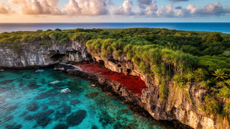
Around it, the Alofi marine terrace forms an almost continuous ring 20 to 30 m high. It descends toward the sea via steep cliffs, notched with coves and chasms (narrow fissures), giving the coastline its spectacular appearance of a limestone rampart.
Cliffs, Caves, and Arches: The Making of Coastal Karst
The perimeter of Niue is almost entirely made of limestone reef cliffs, inherited from past sea levels and continuously reshaped by the swell. Marine erosion sculpts an abrasion notch at the base of the cliffs, then a rocky flat exposed at low tide, dotted with pools, caves, and sometimes marine geysers.
Here you can find:
– spectacular coastal caves like Avaiki Cave, Palaha Cave, Vaikona, Ana, or Togo, where stalactites and stalagmites testify to ongoing karstification;
– sea arches like the Talava Arches on the north coast, a veritable limestone cathedral open to the ocean;
– natural pools like the Limu Pools, clear basins fed by the sea through the reef flat;
– iconic chasms like Matapa Chasm or Togo Chasm, deep fractures where seawater and freshwater mix.
The western coastline is marked by two large bays, Alofi Bay in the center and Avatele Bay in the south, separated by the rocky point of Halagigie Point, which is the island’s westernmost point. Further southwest, the small TePā Point (Blowhole Point) peninsula is famous for its marine geysers, where swells forced into underground conduits can sometimes spout over 30 meters high.
The east and south coasts, exposed to swells, have a narrow fringing reef and steep cliffs. The sheltered west coast offers a wider reef flat with access to the sea, essential for local navigation and fishing.
A Volcano Covered with a Coral Cap
Geologically, Niue is the emerged part of an ancient submarine volcano, capped by a coral limestone platform that can be over 200 m thick. The volcanic cone, now inactive, rises more than 4,000 m above the ocean floor.
Over time, the rise and fall of sea level, combined with the slow tectonic uplift related to the proximity of the Tonga Trench, allowed the reef to grow and then be exposed in stages. Marine terraces like Alofi correspond to ancient reef levels stabilized during warmer interglacial periods, before being uplifted and sculpted by waves.
This history explains the superposition of coral formations of different ages, the presence of a thin layer of volcanic ash in some profiles, and the exceptional density of caves hollowed out in this porous limestone by slightly acidic waters.
Extreme Soils on a Coral Foundation
If there is one feature that distinguishes the geography of Niue, it is the very particular nature of its soils. Resting on reef limestone, these highly weathered tropical soils are both rich in certain elements and dramatically poor in others, strongly conditioning land use and agricultural practices.
A Thin and Fragmented Soil Mantle
The soil cover is thin: on average barely 14 inches, or about 35 cm. On the coral materials of the plateau, the average thickness often does not exceed 30 cm. This thinness is compounded by strong discontinuity: depending on the area, 10 to 60% of the surface may be occupied by limestone rock outcrops, and in dense forest sectors, this rate can exceed 80%.
Nearly half of the island’s surface is occupied by cemented reef rock.
The dominant substrate beneath the soils of the central plateau is a mixture of coral sand and weakly cemented coral debris, locally called “makatea.” This material is also extensively used as aggregate for road maintenance.
Singular Mineralogy and Natural Radioactivity
The soils of Niue belong globally to the broad family of highly weathered tropical oxisols. Their mineralogy is dominated by secondary oxides of aluminum and iron, such as gibbsite, goethite, boehmite, and an aluminum-calcium phosphate known as crandallite. Silicate clay minerals like kaolinite or mica are almost absent, and the silica content is exceptionally low (only 0.3 to 0.6%).
These soils have high levels of thorium-230, protactinium-231, and mercury. This profile, similar to some oceanic sediments, would result from ancient marine submersion, the weathering of corals, and possibly inputs of volcanic ash. No direct health effects have been demonstrated.
There are also internal contrasts: soils developed on the younger Alofi terrace retain a high calcium content and a lower proportion of iron and aluminum oxides, while those in the central basin are more strongly desilicated and enriched in aluminum phosphates.
Chemical Fertility: Excess Calcium, Lack of Potassium
From an agronomic point of view, the soils of Niue are classified as latosols with a high base status. They are generally:
– moderately to strongly alkaline;
– rich in calcium and magnesium;
– endowed with a high phosphorus retention capacity.
But this apparent fertility is deceptive. Exchangeable potassium is low to very low, and zinc deficiencies are frequent, ranging from moderate to severe. Most profiles are poor in organic matter, a consequence of high mineralization under a warm climate and vegetation cover often disturbed by shifting cultivation.
In Niue, the average total phosphorus is about 1%, but it is primarily trapped as crandallite, a poorly soluble and poorly accessible mineral for plants. Its distribution varies by soil type: in the Hakupu soils of the coastal rim, crandallite can make up to 40% of the mineral fraction, while it often only reaches 5% in the soils of the central basin (Fonuakula and Palai types). This concentration follows an increasing gradient from the center to the periphery of the island, inherited from ancient hydrological circulations.
A Mosaic of Soil Series
Field analyses have led to the distinction of several soil series, correlated with major relief and geological units. Among the main ones are:
| Soil Series or Type | Position in the Landscape | Major Chemical Particularities |
|---|---|---|
| Hikutavake | Very rocky areas, northwest | Soils enclosed in massive limestone outcrops |
| Mutalau | Northern plateau, near the highest point | Shallow profiles, numerous surface boulders |
| Hakupu | Raised coastal rim | Up to 40% crandallite, 2–5% magnetite |
| Fonuakula & Palai | Central basin (Mutalau Lagoon) | Dominant gibbsite and goethite, some crandallite |
| Tafolomahina, Fetiki… | Other intermediate positions | Variable properties depending on depth and underlying rock |
All these soils share an ustic moisture regime: they receive enough water on average over the year but experience marked dry periods, during which the profile dries out significantly.
Their texture varies from silts to clay loams and silty clays. Plow layer structure is generally well developed, with fine to medium aggregates of polyhedral or angular blocky type, ensuring good friability and rapid drainage. However, water-holding capacity is low, especially when the effective depth is limited by rock.
A Humid Tropical Climate, but with a Real Dry Season
Despite its classification as a tropical rainforest climate (Af in the Köppen system), Niue is not immune to drought episodes that weigh heavily on agriculture and water resources.
Constant Temperatures, Warm Sea
Temperatures vary little throughout the year: the annual average is around 25–26 °C, with daytime highs of 24–25 °C in the coolest months and 29–30 °C in the warmest. Nighttime temperatures average between 20–21 °C in the cool season and 23–24 °C in the warm season. The sea, meanwhile, stays around 25.5 to 28 °C year-round.
Southeasterly trade winds and daytime sea breezes moderate heat and humidity, offering a generally more pleasant feel than a simple number would suggest. The daily and annual temperature range barely exceeds 4 to 5 °C.
A Rainy Season and a Drier Season
Annual rainfall averages around 2,000–2,100 mm, with a very uneven distribution. From November to April, the warm season, rains are frequent, associated with the South Pacific Convergence Zone and cyclone activity. The months of January to March often concentrate 250–300 mm per month.
From May to October, the region experiences a drier season with only 80 to 100 mm of rain per month, representing about 30% of annual rainfall. Periods of six consecutive months without significant rain can occur. Although rainy days are numerous (over 200 per year), precipitation typically manifests as brief, intense showers.
In this context, high evaporation during the cool season leads to rapid drying of the island’s shallow, highly draining soils, constituting one of the main limits to crop growth.
Cyclones and Climate Variability
Niue lies on the path of the South Pacific tropical cyclone belt. On average, a major cyclone affects the island every few years, with episodes capable of causing enormous damage to infrastructure, vegetation, and coral reefs. Beaches and reef flats are reconfigured with each major event: some areas gain sand, others lose it.
Increase in average temperature compared to the pre-industrial period according to long-term climate observations.
An Island Without Rivers, But Resting on a Large Freshwater Sponge
One of the most surprising features of the geography of Niue is the total absence of rivers, lakes, or surface watercourses, even though rainfall is abundant. This apparent contradiction is explained by the high porosity of the coral limestone and the island’s karst structure.
A Freshwater Lens Hidden in the Limestone
Almost all rainwater that falls on the island quickly infiltrates the thin soil and then the fissured limestone, joining a freshwater lens that floats on the saltwater within the coral massif. This lenticular-shaped aquifer is located about 1 to 3 m above sea level, as measurements at the Fonuakula well have shown.
Total volume of the freshwater lens, i.e., 120 billion liters, supplying wells and boreholes for drinking water and agriculture.
From a hydrological perspective, all infiltrated water that exceeds the level of the lens eventually discharges into the sea: either through diffuse drainage via the porous reef or through spectacular submarine springs, which sometimes gush at the foot of cliffs a few hours or days after heavy rain.
Caves, Chasms, and Water Supply
Interior caves often harbor pockets of fresh or slightly brackish water. Some, like Anapala Chasm near Hakupu village, long served as vital water points for local populations. On the coast, other cavities contain basins of filtered seawater, used as bathing or fishing spots.
The absence of surface water, high infiltration, and a marked dry season make rainwater collection from roofs essential, supplemented by boreholes. Although 97% of the population has access to an improved water source, the vulnerability of the system to droughts and potential pollution of the groundwater lens remains a major management challenge.
Forests, Crops, and Degraded Land: A Fragile Balance
With just over 1,600 inhabitants on 260 km², Niue’s human density is low. Yet, on thin, fragile soils, agricultural and forestry uses leave deep marks. The geography of land use reflects this tension between forest, crops, and impoverished fallow land.
Land Distribution: Predominance of Forest
Recent data indicate that the majority of the island’s surface remains covered by forest or shrubland formations.
| Type of Cover / Use | Approximate Share of Land Surface |
|---|---|
| Forests (primary + secondary) | ~71 % |
| Total Agricultural Land | ~19 % |
| – of which arable land | ~3.8 % |
| – permanent crops | ~11.5 % |
| – permanent pastures | ~3.8 % |
| Other uses | ~9–10 % |
A significant portion – about 22% of the surface – is occupied by secondary forests, shrubland fallows, fern scrub, or sparse maquis, often locally designated as “fernlands” or “desert areas.” These environments largely result from past clearings, repeated shifting cultivation, and the progressive impoverishment of soils.
The last large primary forest on the island is in the Huvalu sector, on the east coast. It is protected by a conservation area covering nearly 20% of the island. This ecosystem hosts exceptional biodiversity, including over 600 species of vascular plants and several endemic species.
Shifting Cultivation and Food Crops
Niue’s economy remains largely oriented toward subsistence agriculture. Most households have a “bush garden” of 0.5 to 2 ha, typically around 1 ha, which they clear and cultivate for a few years before leaving it fallow to try to restore its fertility.
Taro (Colocasia esculenta) is the flagship crop, both for local consumption and export. It is complemented by sweet potato (kumara), cassava, yams, bananas, citrus, coconuts, and various tropical vegetables and fruits. A few plots are dedicated to permanent plantations (fruit trees, coconut palms), but most remain rainfed, non-irrigated agriculture.
The soils are very porous, poor in potassium and organic matter, with very limited water reserves. These characteristics, combined with the absence of irrigation, make the soils unsuitable for intensive market gardening, continuous cropping, or intensive livestock farming.
Deforestation and “Fernlands”
In the past, vast areas were cleared, particularly in the south of the island, to develop taro exports. The use of bulldozers for clearing, the trend toward monoculture, reduced fallow periods, and the use of slash-and-burn accelerated the erosion of topsoil and nutrient loss.
Slash-and-burn, in particular, drastically reduces the stock of plant litter, worsening the potassium deficiency and leaving bare soil exposed to tropical rains. The result: entire areas have turned into fern scrub or nearly bare surfaces, unfit for profitable cultivation without heavy intervention.
It is estimated that about 30 to 40% of the island’s surface is unsuitable for agriculture, and barely 7,500 acres are reasonably well-suited to more intensive agricultural development. Conversely, nearly 60% of the land could offer agricultural possibilities if rigorously sustainable practices and appropriate amendments are implemented.
Sustainable Land Management Initiatives
Faced with these challenges, several initiatives have emerged. A reference report on the island’s soils and agriculture was published as early as the 1960s, and a more recent manual was developed by the Ministry of Natural Resources to help farmers identify different soil types, understand their fertilization needs, and assess the crops best suited to each soil series.
Agroforestry projects combine nitrogen-fixing trees with food crops. For example, after taro harvest, legumes are introduced to restore soil organic matter and nitrogen. These practices are part of broader policies, such as a forest policy and a National Biodiversity Strategy and Action Plan (NBSAP), which include measures for sustainable management of cleared land and restoration of degraded areas.
Training for young farmers, supported notably by NZAid, encourages more soil-friendly practices, while organic farming experiments seek to reduce the use of pesticides. Nevertheless, the country’s small size and lack of resources mean these programs often remain modest in scale.
An Omnipresent Sea: Reefs, Seamounts, and Protected Areas
If the land is fragile, the sea constitutes the great geographical wealth of Niue. Beneath the surface, coral reefs, distant reef islets, and seamounts harbor an exceptional biodiversity, which the country is increasingly striving to protect.
Fringing Reef and Translucent Waters
Around the main island, a fringing reef forms an almost continuous crown. The water clarity is remarkable: the total absence of rivers and thus terrigenous sediments makes the sea clear to depths of 70 to 100 m, sometimes with visibility over 90 m.
The reef appears as a coral flat extending up to a hundred meters offshore before plunging rapidly to great depths. At low tide, a bare flat is visible, pitted with pools and basins, sometimes extended by an emerged reef crest. Beneath this surface, a labyrinth of caves and tunnels allows water to circulate, feeding particularly blowholes and submarine resurgences.
The only significant break in the reef is opposite the capital Alofi, where Sir Robert’s Wharf, the island’s sole freight wharf, is located. Its use depends on calm sea conditions, forcing cargo ships to anchor offshore in heavy swells.
Peripheral Reefs and Seamounts
Beyond the main island, the EEZ of Niue includes several isolated reefs and seamounts, which play a crucial role in regional ecological connectivity.
Among them:
| Reef / Seamount | Approximate Location | Main Characteristics |
|---|---|---|
| Beveridge Reef | ~240 km southeast | Submerged atoll, 9.5 x 7.5 km, lagoon ~11 m deep |
| Antiope Reef | ~180 km northeast | Circular plateau ~400 m diameter, min. 9.5 m depth |
| Haran Reef | ~293 km southeast | Coral reef near the surface |
| Other seamounts | Various within the EEZ | At least 10 to 14 recorded seamounts |
Beveridge Reef, which emerges at low tide but has no permanent land, is particularly important: its waters harbor a record density of gray reef sharks and serve as a stopover for many pelagic and migratory species. More broadly, the reefs and seamounts of the EEZ serve as biological “service stations” for humpback whales, dolphins, sea turtles, large fish, and seabirds.
A Marine Massif Under High Protection
Aware of this wealth, Niue has made the political choice to protect nearly 40% of its EEZ through the Moana Mahu Marine Protected Area (MPA) and the Nukutulueatama Beveridge Reef Special Management Area. These areas, totaling about 127,000 km² – almost half the area of New Zealand – prohibit commercial fishing and any mining, favoring conservation and scientific research.
The entire Exclusive Economic Zone (EEZ) and territorial waters of Niue are regulated by the Niue Nukutuluea Plan. This plan defines a mosaic of zones dedicated to different activities: strictly protected areas, artisanal fishing zones, and sectors reserved for sustainable economic development or tourism.
To finance the long-term management of these areas, an innovative mechanism, Ocean Conservation Commitments (OCCs), has been established: it allows individuals, companies, or organizations to symbolically “adopt” a km² of ocean for 20 years in exchange for a financial contribution, managed by a dedicated trust fund (Niue & Ocean Wide Trust). The goal is to capitalize over 30 million New Zealand dollars to guarantee sustainable means of surveillance, scientific monitoring, and education.
A Geography That Shapes Society and Infrastructure
The imprint of the geography of Niue is also seen in the distribution of the population, the organization of villages, and the way the island equips itself with roads, ports, and an airport.
Villages and Occupation of the West Coast
With fewer than 2,000 permanent residents, the population is concentrated mainly along the west coast, which is more sheltered and more easily accessible to the sea. The capital Alofi, itself divided between Alofi North and Alofi South, accounts for more than a third of the inhabitants and concentrates most services (shops, hospital, airport, administrative center).
The 14 villages that dot the island mostly occupy the fringe between the coastal terrace and the beginning of the central plateau. Each village is a municipal entity with its own council, its customary lands, its agricultural plots, and its access to the sea via paths or tracks.
A Road Network Adapted to the Terrain
A ring road encircles the island along the Alofi terrace, complemented by cross-island roads that climb the gentle slope to the central plateau to reach the villages of the east coast. In total, the road network comprises about 234 km of roads, of which 210 km are sealed. Numerous unsealed tracks crisscross the interior to serve plantations and some sea access points.
The roads follow the lines of least slope and avoid areas with too dense rock outcrops. In very rugged sectors where rock outcrops almost everywhere (like around Hikutavake or Mutalau), locally extracted makatea is used as base material for road maintenance, in keeping with the island’s geology.
Airport and Wharf: Adaptation to Topography and Reef
The sole international airport is located on the western plateau, just south of Alofi, at a moderate altitude but sufficient to ensure stable ground. The runway, over 1,500 m long, was recently reinforced with an asphalt mix using local limestone aggregates, suited to the nature of the soil.
The absence of a natural harbor and the presence of a fringing reef necessitated the construction of an artificial wharf at Alofi, at the only place where an opening in the reef allows access. This wharf only accommodates small flat-bottomed vessels. Large cargo ships must anchor offshore and transfer their cargo by barge, making the country highly dependent on maritime conditions.
Along the rest of the coastline, simple boat ramps, as at Avatele or Namukulu, allow the launching of small craft used for coastal fishing and diving. Here again, the geography – cliffs, reef flat, swell – dictates the location and design of infrastructure.
A Geography Under Pressure: Climate, Soils, and Sea to Protect
The geography of Niue offers obvious assets: spectacular landscapes, soils rich in certain nutrients, clear waters, exceptional marine biodiversity. But it also makes the country particularly sensitive to global changes.
Climate Pressure and Sea Level Rise
Current warming is already reflected in higher temperatures, more marked heat episodes, possible intensification of extreme rainfall, and, above all, an increased risk of intense cyclones. For an island without mountains, where almost the entire territory is below 80 m in altitude and where the coastal fringe is vital for the economy, sea level rise and increased coastal scouring represent a direct threat.
The coral reefs, which protect the cliffs from wave energy and provide much of the beach sand, are being tested by warming and ocean acidification. Sustained bleaching or massive coral mortality would weaken this natural barrier, with repercussions on cliff stability, coastal erosion, and local fisheries.
Soil Degradation and Food Security
On land, soil impoverishment, reduced fallow periods, and increasing dependence on fertilizers and herbicides endanger the resilience of traditional agriculture. Part of the land in the south of the island is already marked by “desert areas” of ferns and scrub, reflecting a cycle of clearing-cultivation-abandonment too rapid for soils to recover.
As the economy relies largely on food and export crops (like taro) and imports are costly and dependent on a single shipping line, maintaining sustainable agriculture on fragile soils is crucial for food security and landscape preservation.
An Open-Air Laboratory for Integrated Management
In this context, Niue finds itself at the forefront of experiments in integrated land management, combining marine conservation, forest restoration, agricultural adaptation, and spatial planning. Numerous national plans (environmental strategy, energy plan, transport plan, marine spatial plan) testify to a willingness to consider the interdependence between soils, climate, sea, and society, in a framework where every square kilometer counts.
Sustainable development initiatives (marine protected area, conservation financing, agricultural training, eco-focused tourism) are not isolated. They are directly inspired by the island’s physical geography, which imposes constraints but also offers unique opportunities for valorization.
—
Niue’s geography, with its formerly lagoon central plateau, its Alofi terrace encircling cliffs riddled with caves, its chemically extreme oxidized soils, its freshwater lens hidden in the limestone, and its immense maritime empire dotted with reefs and seamounts, illustrates how geography goes beyond the simple description of landforms and climates. It conditions the economy, guides culture, structures villages, and forces a small state to invent original responses to global challenges.
On this isolated rock in the Pacific, geography is not a backdrop. It is the very fabric of survival and the societal project.
Disclaimer: The information provided on this website is for informational purposes only and does not constitute financial, legal, or professional advice. We encourage you to consult qualified experts before making any investment, real estate, or expatriation decisions. Although we strive to maintain up-to-date and accurate information, we do not guarantee the completeness, accuracy, or timeliness of the proposed content. As investment and expatriation involve risks, we disclaim any liability for potential losses or damages arising from the use of this site. Your use of this site confirms your acceptance of these terms and your understanding of the associated risks.

Cyril Jarnias is an independent expert in international wealth management with over 20 years of experience. As an expatriate himself, he is dedicated to helping individuals and business leaders build, protect, and pass on their wealth with complete peace of mind.
On his website, cyriljarnias.com, he shares his expertise on international real estate, offshore company formation, and expatriation.
Thanks to his expertise, he offers sound advice to optimize his clients' wealth management. Cyril Jarnias is also recognized for his appearances in many prestigious media outlets such as BFM Business, les Français de l’étranger, Le Figaro, Les Echos, and Mieux vivre votre argent, where he shares his knowledge and know-how in wealth management.





