
 Published on and written by Cyril Jarnias
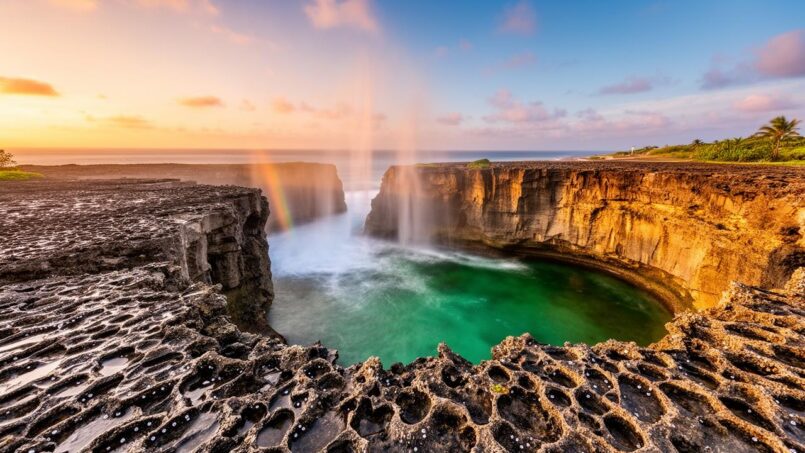
Niue is nothing like a postcard atoll covered in long white sandy beaches. Nicknamed “The Rock of Polynesia,” this small 260 km² island is actually a massive block of limestone raised from the ocean, ringed by cliffs, sea caves, natural pools, and reefs. It is precisely this atypical geography that makes it one of the Pacific’s most astonishing playgrounds for those who love swimming in rock-cut pools, diving in limestone cathedrals, walking on reefs at low tide, and observing whales and dolphins just tens of meters from shore.
The network of over thirty marked trails, called “sea tracks” or “Hala Tahi,” provides access from the coastal road to the island’s main natural sites: caves, arches, chasms, and hidden beaches. Each trail leads to a unique setting, shaped by limestone, coral, and crystal-clear waters.
Understanding the Playground: A Limestone Island Sitting on the Ocean
Niue is a massive raised coral atoll, entirely composed of limestone. There are no rivers, lakes, or large lagoons. The interior is flat, covered in dense tropical rainforest, while the coast forms a succession of cliffs, fringing reefs, and coral platforms riddled with crevices, caves, and natural pools. The absence of rivers also means an almost complete absence of sediment: the water around the island is of exceptional clarity, with visibility frequently exceeding 30 to 40 meters, and can reach up to 80 or 100 meters under ideal conditions.
The coastline described has few beaches, with sharp rocks and coral platforms subject to tides. It is imperative to check tide times, wear reef shoes, not underestimate currents, and accept that some sites are only accessible at low tide or at a specific time.
To gauge this contrast with other Pacific destinations, just look at the average coastal profile: 20-meter cliffs, a small reef platform at low tide, dropping abruptly into the deep blue from about forty meters deep. It’s this relief that allows whales to swim within 100 meters of the cliffs and gives the natural pools that particular electric-blue color.
Limu Pools, Matapa Chasm, and Talava Arches: The Magical Trio of the Northwest
The north and northwest-facing coast is home to three of Niue’s most iconic sites: Limu Pools, Matapa Chasm, and Talava Arches. They alone summarize the island’s DNA: clear-water pools, lush caves, monumental arches, and living reefs.
Limu Pools, the Grand Natural Swimming Hole
Limu Pools, near the village of Namukulu, is often cited as the island’s most beautiful swimming spot. A short five-minute walk on a well-maintained trail leads to a series of turquoise pools nestled in a rocky cove. Here, seawater mixes with underground freshwater, sometimes creating a slight temperature stratification and shifting reflections.
The sheltered configuration of the cove makes it an ideal spot for families, provided the tide is respected. The main pools are particularly pleasant from mid-rising tide to high tide, when the depth is sufficient and water exchange maintains excellent visibility. At low tide, some pools become shallow, perfect for toddlers to splash in clear, warm water, while parents relax on the rocky platforms. Simple amenities – stairs, shaded areas, benches – make the place comfortable without spoiling it.
A small side trail leads to a second spectacular pool, framed by a coastal arch. However, this site is more exposed to ocean surges: it is essential to visit with caution, especially when the water level is high. To fully enjoy observing tropical fish and underwater cavities at the foot of the walls, wearing a mask, snorkel, and reef shoes is almost mandatory.
Matapa Chasm, the Royal Bath Between Cliffs
A few kilometers further west, near the village of Hikutavake, Matapa Chasm sinks like a deep gash at the foot of high cliffs. Historically, this calm water corridor was the bathing pool reserved for the ancient kings of Niue. Today, it’s travelers who slip into this cool, clear water.
Access is remarkably easy: a nearly flat forest trail, just five to seven minutes from the parking lot. Upon arrival, a kind of mineral corridor closed off by two high walls opens onto a deep pool where seawater is mixed with an underground freshwater vein. The result: a cool, almost cold surface layer compared to the rest of the island, sitting atop a warmer layer of saltwater. When free-diving, you can distinctly feel this ‘layer’ difference in temperature and density.
The Chasm’s configuration, protected from waves by large rock blocks at its entrance, allows for safe swimming at almost all tide levels. A light, moderate current is noticeable near the exit. The site offers more than just a swim: as you move towards the back, you discover nooks, small caves, and an astonishing density of surprisingly unafraid tropical fish. Facilities like toilets, showers, and a parking lot make it a very accessible place while preserving its natural character.
Visitor reviews, often raving, highlight the water clarity, abundance of fish, and the “magical” atmosphere of the place, especially when the low morning or late afternoon light grazes the limestone walls.
Talava Arches, Mineral Cathedral at Low Tide
From the same parking lot as Matapa, another trail, longer and more demanding, heads towards the sea: this is the start of the path to Talava Arches. Here, the experience changes. No more easy trail; it’s time for a hike of about 30 minutes each way, on a sometimes slippery path, dotted with sharp coral, roots, and passages through the coastal forest.
The route first crosses dense vegetation, then a chaos of limestone carved by erosion. You progress between coral pinnacles, over irregular slabs, before emerging into a cavity resembling a small karst cave. Ropes have been installed to secure some descents, and you sometimes have to slide or lean to get past the steepest sections. The effort is rewarded when a large opening in the rock, like the apse of a cathedral, suddenly reveals a monumental arch, carved by centuries of wave attack.
Trail Description
At low tide, it’s possible to descend onto the reef flat and walk to the foot of the arch, crossing crystal-clear pools where fish and pink corals live. On calm days, some pools even allow you to swim in this aquarium-like water. At high tide or with strong swell, any change in water level can make progress dangerous: local authorities clearly advise planning the visit around low tide, wearing closed shoes rather than simple reef sandals.
The area is also a privileged observation point over the open ocean. Travelers mention having seen whales in season beyond the reef. Historically, this promontory also served as a lookout post to spot passing ships or enemy raids. Between the limestone formations, stalactites, and the vast view of the ocean, Talava Arches ticks all the boxes of an “effort rewarded” site.
To visualize the complementarity of these three sites, we can summarize their key characteristics:
| Site | Type of Place | Access & Approx. Duration | Recommended Tide | Main Audience |
|---|---|---|---|---|
| Limu Pools | Mixed natural pools (salt / fresh water) | 5 min walk, developed trail | Mid-rising to high tide; low tide for kids | Families, beginner to intermediate snorkelers |
| Matapa Chasm | Deep-water chasm between cliffs | 5–7 min, easy trail | All tide levels | All visitors, swimmers and snorkelers |
| Talava Arches | Limestone arches, reef pools | 30 min, rocky trail | Low tide imperative | Hikers, experienced snorkelers |
Chasms, Caves, and Beaches of the Central-West: Avaiki, Palaha, Hio, Utuko
Following the main road north from Alofi, the capital, the west coast unveils a series of spectacular caves, small beaches, and chasms. Here again, everything happens at the scale of the “sea tracks” marked by blue signs.
Avaiki Cave, Calcite Cathedral and Hidden Pool
Between Makefu and Tuapa, a sign indicates access to Avaiki Cave. A few minutes’ walk is enough to plunge into the setting of a large coastal cave, with a high ceiling, sculpted walls, and a natural pool where seawater laps at the foot of the cave at low tide. The rocks are often slippery, and a visit is strictly discouraged outside of low tide: at rising tide, waves flood the cavity and make any progress risky.
Beyond aesthetics, the site has strong symbolic weight: according to tradition, it is here that the first Polynesian canoe landed, marking the beginning of the island’s settlement. Today, visitors come to swim in a protected pool surrounded by stalactites and limestone columns. With mask and snorkel, you weave between rocks, among some corals and fish that have settled in this dark micro-universe.
Palaha Cave, Limestone Sculptures and Windows on the Reef
Just a few hundred meters south, another sign points to Palaha Cave. The five-minute walk leads to an even larger cave, with a profusion of stalactites and stalagmites in shades ranging from green to red. The extremely slippery floor requires careful walking. Here, the interest is as much geological as marine: you explore the chambers, observe details of the rock, contemplate fossils embedded in the limestone, then move towards the exit to discover the coral reef flat stretching as far as the eye can see.
At low tide, the reef reveals small natural pools, miniature ecosystems perfect for close-up observation of marine life.
Small pools form on the reef, offering pockets of calm, protected water for a peaceful immersion.
These shallow basins are ideal for observing corals and juvenile fish up close, unlike deeper pools like at Limu or Matapa.
Hio Beach, the Sandy Cove and Its Pools
Further south, in Tuapa, the Hio Sea Track descends from the main road towards one of the rare sandy coves on the west coast. A staircase leads to a small bay of golden sand, surrounded by rocks and overlooked by the Hio Café & Bar, perched atop the cliff.
The site is very photogenic with its turquoise water and fine sand. Tide timing is crucial: about 30 minutes before and 1 hour after low tide, a passage in the reef to the right allows access to a pool for swimming and snorkeling. Walking further along the beach to the right, another pool near the cliff offers a warm, calm immersion, similar to a thermal bath.
The more curious can, at very low tide, reach a small cave north of the cove. This stretch of coast also holds the memory of the 1877 wreck of the Peruvian ship Irole, one of the darkest episodes of the slave-hunter period in the Pacific.
Utuko Reef, Alofi’s “Garden”
Right in the heart of Alofi, a detour to Utuko Reef – easily spotted next to the Crazy Uga Café – shows what a “town beach” looks like in Niue. You’ll find a small sandy cove, a reef accessible on foot at low tide, and pools perfect for those learning to snorkel or traveling with young children. At low tide with a calm sea, you can float over corals, walk from pool to pool, and observe fish, giant clams, and sometimes turtles in water that’s amazingly clear for a site so close to the village center.
The main recommendations for this entire western stretch can be summarized as follows:
| Site | Main Attraction | Key Tide | Required Level |
|---|---|---|---|
| Avaiki Cave | Large cave + snorkeling pool | Strictly low tide | Good footing, caution on rocks |
| Palaha Cave | Colorful limestone formations + pools | Low tide | Cautious walkers |
| Hio Beach | Sandy cove + natural pools | 30 min before to 1 hr after low tide | Beginner to intermediate swimmers |
| Utuko Reef | Town pools for easy snorkeling | Low tide, calm sea | Families, beginners |
Avatele Bay, Tamakautoga, and the Southwest: Beaches, Reefs, and Whales
On the southwest coast, Avatele Bay unfolds in a wide curve from Tepa Point to Halagigie Point, the island’s westernmost tip. Two villages – Avatele and Tamakautoga – dot this bay, surrounded by sites that combine beach, reef, water activities, and accommodations.
Avatele Beach, the Bay’s Snorkeling Spot
Near the village of Avatele, a marked “sea track” descends to a coral beach. This is one of the classic snorkeling spots, with a high concentration of tropical fish, accustomed to feeding in this reef sector. Swimming here is especially enjoyable from mid-tide to low falling tide, when the depth still allows swimming without scraping coral, but transparency and current remain favorable.
The bottoms near the boat ramp, however, should be avoided: powerful currents occur there, in addition to a freshwater outflow that disrupts swimmers’ balance. At very low tide, some areas become so shallow that coral is exposed: then maintain a respectful distance to avoid damaging it and prevent cuts.
Tamakautoga Beach & Togulu Sea Track, the Village Beach
Just to the north, in the village of Tamakautoga, the Togulu Sea Track leads in moments to a small cove of coral sand. There’s a sandy-bottomed water hole usable at both high and low tide for paddling, making it a popular spot for village families. The toilets and showers installed at the top of the track add a rare comfort for such an intimate site.
At low tide, the reef is fully exposed, allowing for walks on foot or snorkeling.
The Tamakautoga area is also a home base for most of the island’s major water activities. This is where Buccaneer Adventures Niue Dive departs from, offering scuba diving, snorkeling trips, glass-bottom boat rides, stand-up paddleboarding, ATV tours, and renting masks, fins, life jackets, underwater cameras, and full diving gear. Underwater visibility, around Tamakautoga as elsewhere, commonly ranges between 30 and 100 meters, thanks to the absence of runoff and the island’s limestone nature.
These waters harbor a rich marine fauna – parrotfish, corals of all shapes, sea snakes, turtles – and serve as a playground year-round, with a major bonus between July and October: the regular presence of humpback whales.
Humpback Whales: The Cetacean Highway Within Reach of the Cliffs
Niue is positioned on what biologists call a humpback whale “migration corridor.” Every year, these giants from Antarctica travel over 8,000 kilometers to reach the warm waters of the central Pacific where they mate, give birth, and raise their young. The particularity of Niue, with its seabed quickly dropping to over 300 meters, is that these whales can swim just 20 to 200 meters from the coast, sometimes practically under the cliffs.
From July to October, it’s not uncommon, from the terrace of the Scenic Matavai Resort in Tamakautoga, along the coastal roads of Avatele, or from promontories like Tomb Point in Alofi, to spot blows, breaches, and calf play just tens of meters from shore. This proximity is such that the island has developed a strictly regulated, absolutely unique activity: swimming with humpback whales, managed by a handful of authorized operators (Niue Blue, Explore Niue, Buccaneer Adventures Niue Dive).
Tours are conducted in small groups of 5-6 people, led by a guide. After a briefing on whale behavior and safety rules (minimum distance of 20 meters), observation begins from the boat. Interaction in the water only occurs if the whales, especially a mother and her calf, show interest. Swimmers stay grouped and still at the surface. Duration is limited, especially in the presence of a calf, to avoid any stress.
Operators like Niue Blue even have hydrophones that allow you to listen to the songs of males resonating through the water, sometimes for several tens of kilometers. Travelers’ accounts speak of the power of this moment: seeing a 12 to 16-meter animal emerge in the deep blue, feeling its song vibrate in your chest, while knowing this privilege rests on a set of strict rules designed for the protection of the species.
To complete the picture of the southwest, Tamakautoga is also home to the Scenic Matavai Resort, the island’s only “full-service resort.” Two freshwater pools with an in-pool bar, restaurant, cocktail bar, and tour service transform the bay into a comfortable base camp for exploring Limu, Matapa, Avaiki, Togo Chasm, and Avatele.
The Wild East: Togo Chasm, Liku, and the Reef Trails
While the west coast concentrates the majority of swimming spots, the eastern side – more exposed to the trade winds, wilder – offers some of the island’s most memorable sites, especially for hiking and a sense of isolation.
Togo Chasm, Oasis Hidden in a Coral World
In the heart of the Huvalu Forest Conservation Area, on the east coast, a sign indicates access to the Togo Chasm Sea Track. This is one of Niue’s longest “sea tracks”: between 30 and 45 minutes of walking depending on your pace. The trail starts in primary forest, crosses an area of coral pine, then emerges onto a rocky plateau bristling with limestone pinnacles, like an army of daggers pointing skyward.
After a vertical descent of about 12 meters between pinnacles, the bottom of a chasm reveals a small, unexpected oasis, composed of a ribbon of sand, coconut trees, and rock blocks. Climbing on these blocks, you can glimpse the sea behind the wall, its presence betrayed by the rumble, vibrations, and splashes filtering through the cracks, though it remains invisible from the bottom.
The site is not a swimming spot like Limu or Matapa, but a landscape experience, almost surreal. It feels like being in a secret chamber the ocean carved out hidden from view. Closed shoes are “non-negotiable” here: you walk a long way on sharp coral, and the ladder rungs require good stability.
Liku, Tautu Reef, and Sunrises
Further north, the village of Liku serves as a starting point for several coastal access points. The Tautu Sea Track, in particular, follows a steeply sloping track leading to a small parking lot at the edge of the plateau. From there, a short passage under a natural arch opens onto Tautu Reef, a large coral flat dotted with basins and small sandy coves revealed at low tide. The place is famous for its sunrises: facing east, you see the sun’s disk emerge from the ocean, igniting the still-wet asperities of the coral.
At low tide, you can walk on the reef, look for crabs, mollusks, eels trapped in water holes. Swimming is not the main attraction, but walking on the flat, taking photos, and observing the coastline give another image of Niue, less aquatic, more mineral.
Also on the east coast, the Motu Sea Track, between Liku and Lakepa, illustrates the more challenging dimension of some coastal hikes. After a dirt road of nearly 1.4 km that is often advised to walk, the trail itself crosses rocky terrain to a natural arch in the cliff. A staircase allows you – at low tide only – to descend onto the reef. Here again, it’s more about exploring landscapes, intertidal fauna, and spectacular viewpoints than seeking out large swimming pools.
Freshwater Chasms and Interior Forests: Anapala, Huvalu, Vaikona
Niue is not limited to its coast. Its central plateau, perched about 60 meters above sea level, is covered in forests where some curiosities hide, especially freshwater chasms used in the past as natural cisterns.
Anapala Chasm, the Stairway to the Spring
Near the village of Hakupu, a sign indicates the Anapala Chasm Sea Track. After leaving the main road, a track leads to a small parking lot. From there, a well-marked forest trail, about fifteen minutes long, leads to a staircase that literally plunges into the rock. You descend between 146 and 155 steps, enveloped in shade and humidity, until you reach a narrow corridor where cold, clear freshwater fills the bottom.
For generations, this water was the main source for Hakupu’s inhabitants. Today, the chasm resembles an underground pool, eerily quiet. You can swim here, but the ambiance – close walls, darkness, echoes – encourages whispering as much as bathing. A flashlight is highly recommended to gauge depth and inspect nooks. This is not a coral snorkeling site, but an immersion into a piece of the island’s daily history.
Huvalu Forest and Vaikona Chasm, the Island’s Green Underbelly
The Huvalu Forest Conservation Area covers a large portion of the island’s east. It is one of the last large blocks of Niue’s native forest, where ancient trees and medicinal plants grow, and where the peka, a large fruit bat, the island’s only native terrestrial mammal, lives. Explanatory panels line some trails, and a 2 to 3-hour hike allows you to roam this massif, observe giant trees, spot traces of traditional cultivation, and encounter, at dusk, these large silhouettes of bats.
Access to Vaikona Chasm, in the north of the forest, is strictly regulated and requires a guide due to dangerous terrain (holes, aggressive karst, dense areas). After a walk over broken coral, you discover a chasm covered in ferns with a freshwater pool for a well-earned icy dip. This site illustrates how Niue, despite the absence of rivers, possesses a significant freshwater reserve in its limestone substrate.
Sea Tracks Around the Island: A Network to Explore Caves, Reefs, and Viewpoints
One of Niue’s great strengths, for those who like to explore on their own, lies in the density and clarity of its “sea track” network. Over 30 access points, marked by blue signs, dot the coastal road. Driving leisurely, you come across a new starting point every 10 to 20 minutes. Some lead in moments to a small viewpoint or a cave used for storing canoes (vaka). Others require a real walk, an hour or more, to the most remote sites.
To illustrate the diversity mentioned in the article, here are some emblematic examples:
| Sea track / site | Main Characteristic | Primary Use |
|---|---|---|
| Amanau (South Alofi) | Small cave with pool for snorkeling at low tide | Swimming, snorkeling |
| Opaahi (Alofi) | Historical rock of Cook’s second attempted landing | Viewpoint, history, rough sea |
| Vaila Cave (North Alofi) | Vaka cave + access to the marine protected area | Canoe storage, reef snorkeling |
| Pofitu (between Tamakautoga & Avatele) | Tiny beach covered in corals and seashells | Walk, shell searching |
| Puluhiki (Lakepa) | Reef platform with wide panoramic view of east coast | Sunrise, walking on the reef |
| Tuhia / Hakupu Sea Track | Rock pools and picnic area with barbecue | Family stroll, picnic |
| Uluvehi (Mutalau) | Wide concrete path to caves and reef | Accessible for people with reduced mobility, exploration |
The tourist office based in Alofi, right next to the market, centralizes maps, tide information, and safety advice. It can also recommend guides for more technical excursions, especially to Vaikona Chasm or some caves still forming.
Beneath the Surface: A Paradise for Snorkelers and Divers
While the natural surface pools are often talked about, one of Niue’s major assets remains invisible from above: its network of underwater caves, tunnels, chasms, and drop-offs, discovered with a mask on your face or a regulator in your mouth.
The reef drops quickly to 40 meters deep before plunging into the almost bottomless “blue.” Dives describe a world of hard corals, fissures, “cathedrals” bathed in light, vertical tunnels like “The Chimney” (a well descending from 5 to nearly 28 meters before exiting into a large chamber), or caves like Bubble Cave, where you enter at 8 meters depth and surface into an air bell at the back of the cavity.
Sites like Snake Gully, Coral Nursery, and Limu Twin Caves offer a unique diving experience with coral gardens, forests of antler coral, and passages under rock. You encounter a varied fauna: endemic sea snakes *katuali*, barracudas, butterflyfish, parrotfish, groupers, moray eels, and depending on the season, turtles, tuna, or sharks (white tip, black tip, grey reef). Visibility, usually over 30 meters, provides a feeling of flying over the terrain.
Snorkeling, on the other hand, exists at different scales: Limu’s pools, Matapa’s and Anapala’s chasms, Utuko’s basins, the flat reefs of Hikutavake or Vaila, the flooded caves of Avaiki. Where swell permits, boat trips complete the offering, with stops at outer sites not accessible from the coast, and often encounters with long-beaked dolphins playing in the bow wave.
Culture, Nature, and Responsible Tourism: What the Sites Reveal
Beyond the aesthetics or “Instagrammable” aspect of the places, the must-see tourist sites in Niue also tell a story of cohabitation between a community of some 2,000 inhabitants and a fragile environment. The caves where we swim today – Palaha, Avaiki, Anapala – have long served as shelters, places of worship, storage points, or water reserves. The rocky platforms where canoes (vaka) are stored recall the ancestral dependence on the sea. The Huvalu forests or chasms like Vaikona highlight the value placed on native ecosystems.
Conscious of its vulnerability, the island has established protected areas, including a large ‘no-take’ marine zone north of Alofi (Niue Moana Mahu) and terrestrial reserves like Huvalu. Strict codes of conduct for visitors (do not touch limestone formations, move canoes, take natural elements, and the obligation to take your trash back) are disseminated by accommodations and tourist operators.
This approach is felt even at the most visited sites. At Matapa, no ostentatious development pollutes the landscape, but the trail is clearly laid out, educational signs are present, and the restrooms are discreet. At Limu, picnic areas and simple shade sails welcome families and groups without saturating the space. At Talava, the absence of guardrails at the edge of the arch reminds you that you’re not in a theme park: here, everyone is responsible for their own steps.
These village days complete the discovery of natural sites. You can taste specialties like takihi (taro and papaya in coconut milk), watch the preparation of umu (underground ovens), and may buy weavings (lafalafa) and sometimes uga, the giant coconut crab that can weigh up to 4 kg.
Guided tours like Taue Uga Tours, plantation visits (A5 Plantation Tours, Maala Garden), or outings to see the peka (bats) underline this desire to offer small-scale, immersive tourism that funds conservation rather than endangering it.
Preparing Your Explorations: Tides, Seasons, and Safety
All these sites share a common constraint: dependence on the tide and, to a lesser extent, the seasons. Many “must-sees” only fully reveal themselves around low tide (Avaiki, Palaha, Hio, Tautu, Motu, Togo Chasm) or mid-rising tide (Limu, Hio). Some remain accessible at all times, like Matapa or Avatele, but change appearance depending on the water level.
The ideal period for activities (chasms, natural pools, hikes) and whale watching runs from May to October, during the cool, dry season. Peak visitation and maximum whale presence occur between July and September. March is the quietest month. The wet season, from December to March, can lead to partial activity closures and carries a cyclone risk.
The most recurrent recommendations for safely enjoying these sites can be condensed as follows: check tide times every day, avoid exposed coastlines during heavy swell, wear closed shoes on all rocky trails (Talava, Togo, Motu, Vaikona), take a flashlight into caves and chasms, and, for the most remote hikes, go with a companion or inform someone of your destination.
An Archipelago of Micro-Worlds to Explore
What strikes you after a few days exploring the must-see tourist sites in Niue is how each “sea track” seems to open onto an autonomous micro-world. Limu offers its world of pools mixing fresh and saltwater; Matapa, its royal corridor of cold water; Talava, its cathedral arches; Avaiki, its sanctuary cave; Hio, its little tropical beach; Togo, its hidden oasis; Anapala, its staircase to a buried spring.
Unlike many island destinations, Niue does not rely on the repetition of white sandy beaches, but on a diversity of coastal landscapes concentrated over a few dozen kilometers. The experience favors active exploration over simple contemplation. To fully enjoy it, you must be ready to walk, adapt your schedule to the tides, and swim in sometimes cool pools, which transforms the island into a unique mineral and aquatic playground.
The sites presented here are just a selection among the thirty or so coastal access points, interior forests, caves, and chasms that literally ionize this rock set in the middle of the Pacific. But they constitute a solid thread for understanding Niue: an island that, far from beach clichés, makes each cave, each arch, each natural pool a destination in its own right.
Disclaimer: The information provided on this website is for informational purposes only and does not constitute financial, legal, or professional advice. We encourage you to consult qualified experts before making any investment, real estate, or expatriation decisions. Although we strive to maintain up-to-date and accurate information, we do not guarantee the completeness, accuracy, or timeliness of the proposed content. As investment and expatriation involve risks, we disclaim any liability for potential losses or damages arising from the use of this site. Your use of this site confirms your acceptance of these terms and your understanding of the associated risks.

Cyril Jarnias is an independent expert in international wealth management with over 20 years of experience. As an expatriate himself, he is dedicated to helping individuals and business leaders build, protect, and pass on their wealth with complete peace of mind.
On his website, cyriljarnias.com, he shares his expertise on international real estate, offshore company formation, and expatriation.
Thanks to his expertise, he offers sound advice to optimize his clients' wealth management. Cyril Jarnias is also recognized for his appearances in many prestigious media outlets such as BFM Business, les Français de l’étranger, Le Figaro, Les Echos, and Mieux vivre votre argent, where he shares his knowledge and know-how in wealth management.





