
 Published on and written by Cyril Jarnias
Stuck in the middle of the Pacific, geologically shaped by a long-gone volcano and upheaved by a century of phosphate mining, Nauru offers a geography that is both simple on the map and extraordinarily complex on the ground. This article provides a comprehensive overview of the country: location, terrain, climate, resources, as well as environmental impacts and challenges related to climate change.
A Micro-State at the Heart of the Pacific
Geographically, Nauru is a global anomaly. The country is a single oval-shaped island resting on the Pacific Plate, far from any continent. With 21 km² of land area – barely larger than some small districts of major cities – it is the third smallest state in the world, behind Vatican City and Monaco, and the smallest country in the Pacific.
The island is located in the southern part of Micronesia, about 53 km south of the equator (coordinates: 0°32′S and 166°55′E). This direct proximity to the equator gives it a very consistent climate and a constant day length of about 12 hours of light year-round.
The nearest neighbor is Banaba (Ocean Island), an island of Kiribati, nearly 300 kilometers to the east. Other inhabited lands – such as the Solomon Islands, Tuvalu, or Papua New Guinea – remain several hundred or even thousands of kilometers away. This relative isolation has long shaped the country’s economy, supply of goods, and vulnerability.
A Raised Atoll Formed by a Vanished Volcano
Geologically, Nauru is not a simple sand islet lost on a reef: it is a raised atoll. The story begins at the bottom of the Pacific Ocean, over 100 million years ago, with the formation of an underwater volcano over a hot spot. This basaltic seamount, over 4,300 meters high, eventually reached the surface, was planed down by erosion, and was capped by a coral structure.
Over millions of years, a coral ring developed, reaching about 500 meters in thickness. Subsequently, tectonic uplift raised the entire landmass about 30 meters above sea level. This process transformed the former atoll into a “raised atoll,” characterized by a crown of dolomitic limestone. This limestone was later sculpted by dissolution and erosion, giving rise to a typical karst landscape, with pinnacles, cavities, and sinkholes.
This morphology explains two strong signatures of Nauru’s relief: a flat, low perimeter, and an interior that is higher and bristling with rocks. The island continues to drift with the Pacific Plate, at a rate of about 10 centimeters per year toward the northwest, but this movement is imperceptible on a human scale.
A Relief Simple in Appearance, Fractured in Reality
On a topographic map, Nauru boils down to three main areas: a coastal belt, an escarpment of coral cliffs, and a central plateau. In local language, a clear distinction is made between the “Bottomside,” the coastal fringe, and the “Topside,” the interior plateau.
The coastal strip forms a sandy ribbon that is relatively flat, generally 100 to 400 meters wide, sometimes up to 300 meters for the most fertile part. It barely exceeds 10 meters in elevation, making it particularly exposed to marine inundation and storm surges. Yet this is where most of the population and infrastructure is concentrated: homes, roads, airport, hospital, power plant.
Beyond the coastal strip, a coral limestone cliff leads to a central plateau culminating at Command Ridge (60-70 m). This interior, once covered with phosphate soils and sparse forests, is now largely devastated by a century of mining.
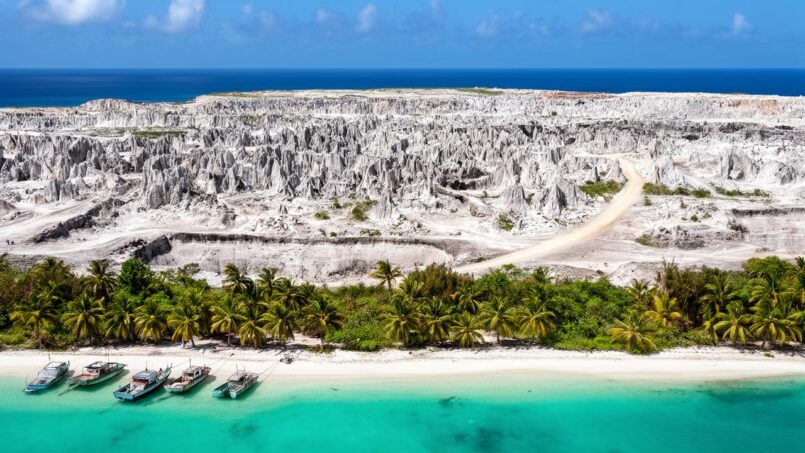
The Topside is now characterized by a jumble of limestone or dolomite pinnacles, sometimes 15 to 20 meters high, separated by basins and cavities once filled with phosphate. Some depressions have evolved into deeper karst structures, creating caves and underground lakes, such as at Moqua Cave in the southeast of the island.
Buada Lagoon and Other Wetlands
A notable exception to this mineral landscape is Buada Lagoon in the southwest. This shallow inland lagoon occupies an ancient karst collapse. Surrounded by slightly deeper and less rocky soils, it is one of the few places inland where denser vegetation persists and subsistence agriculture remains possible.
Swamps and small ponds, especially in the districts of Ewa and Ijuw-Anabar, contribute to groundwater recharge and provide refuge for specific plant and animal species. Their ecological role is notable despite their small size. However, their capacity as a sustainable water resource is limited by the high permeability of the underlying limestone soil.
An Island Without Rivers
Nauru has no permanent watercourses. The highly porous limestone structure promotes rapid infiltration of rainwater, preventing the formation of rivers or surface lakes, with the exception of Buada Lagoon and a few brackish ponds. Freshwater resources therefore rely on rainfall, groundwater lenses highly vulnerable to salt, and collection or desalination infrastructure.
A Coastline Encircled by the Reef
Around the island stretches a narrow reef flat, generally 50 to 300 meters wide. This fringing reef is exposed at low tide, revealing coral pinnacles and rocky areas where algae, invertebrates, and corals cling. Seaward, this flat suddenly gives way to the open ocean: the seabed plunges very quickly to depths of nearly 1,000 meters less than 2 kilometers from the coast.
A Protective but Constraining Reef
This reef acts as a natural barrier against swell and storm waves, but it seriously complicates maritime access. Nauru has no natural harbor or sheltered lagoon. Large ships must anchor offshore, and people and goods are transferred by barge or small boats through narrow passes.
Anibare Bay, on the east coast, was formed by the collapse of a flank of the underlying volcano. This slide created an amphitheater open to the ocean with more accessible depths. However, the persistent presence of the reef imposes technical constraints for any port development.
A Vast Maritime Economic Zone
On a maritime scale, Nauru’s geography is reversed: tiny on land, the country controls a vast Exclusive Economic Zone (EEZ) of 200 nautical miles, or about 308,480 km². In this area, the country exercises sovereign rights over biological and mineral resources: fish (especially tuna), as well as potential deep-sea deposits of polymetallic nodules, subject to exploratory projects.
A Very Stable Equatorial Climate… but Fickle in Rain
Located very close to the equator, Nauru enjoys a hot and humid climate, with very low temperature variation throughout the months. Recent data (1991–2020) shows average minimum temperatures around 25–26 °C at night and maximums near 31–32 °C during the day, month after month.
The sea surrounding the island also shows remarkable consistency: about 29 °C at the surface year-round, ideal for swimming but a potential stress factor for corals in case of additional warming.
A Seasonal Cycle Dominated by Rain
Seasonality in Nauru is not marked by temperature, but by precipitation. There is typically a wetter period from November or December to April, and a relatively drier period from May to October. However, “dry” is a relative term: several hundred millimeters of rain still fall during these months.
Monthly data show for example that: they serve to illustrate and support the trends or points addressed in the article content, offering a precise temporal perspective.
| Month | Average Rain (mm) | Rainy Days (≈) |
|---|---|---|
| January | 264 | 21 |
| February | 225 | 22 |
| March | 214 | 23 |
| April | 201 | 20 |
| May | 183 | 21 |
| June | 165 | 19 |
| July | 211 | 21 |
| August | 171 | 20 |
| September | 162 | 21 |
| October | 171 | 22 |
| November | 174 | 19 |
| December | 242 | 21 |
On an annual average, rainfall is around 2,000 mm, as much as some large tropical forests. But this average masks enormous interannual variability. Exceptionally dry years receive only 885 mm (historical minimum), while very wet years have exceeded 5,400 mm, as in 1987.
The island has no rivers, making La Niña-related droughts particularly problematic.
Omnipresent Sun and Extreme UV
Day length remains close to 12 hours in all seasons, and solar radiation is intense. Maximum UV indices very regularly reach 11, the highest level on standard forecasting scales. The combination of heat, humidity, and UV imposes constant recommendations: light clothing, hat, sunglasses, as well as protection against sudden downpours.
Forecasters consider the period from May to September to offer, on average, slightly more favorable conditions for outdoor activities, with the atmosphere being a little less laden with clouds and rain, especially in the Yaren district. However, even at the heart of this “best period,” brief and intense thunderstorm showers remain frequent.
A Climate Geography Already Altered by Warming
Climate analyses highlight a clear warming trend over Nauru since pre-industrial times. Between 1850–1900 and the period 1986–2005, the estimated average temperature increase is around 0.6 °C, reaching about 0.8 °C when compared to the decade 2011–2020. Step-like shifts appear to have occurred, including a notable jump in temperature levels after the early 2000s.
Long-term precipitation projections in the equatorial zone are highly uncertain. Data series are incomplete, natural annual variations are large, and climate models have difficulty simulating this region. Projections vary significantly from one model to another, ranging from stability to a strong increase or a slight deficit in rainfall. On average, simulations rather suggest an increase, especially by the end of the century, but this average trend hides a very wide dispersion of results.
What is clearer, however, is the increase in sea temperature and sea level rise, already measured at a rate of 3.5 to 4.5 mm per year since the early 1990s. In the central Pacific, this rise is about three times faster than the global average, due to regional ocean factors.
In the most pessimistic scenarios, up to 80% of currently usable coastal land could become uninhabitable by 2100.
Climate Scenarios for Nauru
Experts have developed several scenarios combining different levels of emissions and atmospheric responses. They all depict a hotter future, but diverge on rainfall. A few typical trajectories can be summarized:
| Scenario | Emissions / Forcing | ΔAnnual Temperature | ΔAnnual Rainfall | Other Major Effects |
|---|---|---|---|---|
| 1 | Low (RCP2.6 type) | +0.7 °C | –20% | More heatwaves, drier air, increased radiation, more intense rainfall events, sea level rise of ~17–30 cm |
| 2 | Low (RCP2.6) | +2.0 °C | +50% | Strong increase in heatwaves, higher humidity, less direct sunlight, much more frequent extreme rainfall, same order of sea level rise |
| 3 | High (RCP8.5) | +1.1 °C | –5% | More extreme heat, drier air, increased sunshine, enhanced extreme rainfall, sea level rise of 21–36 cm |
| 4 | High (RCP8.5) | +2.0 °C | +80% | Numerous heatwaves, strong increase in humidity, decrease in direct sunshine, extreme rainfall events, sea level rise 21–36 cm |
Even in “drier” scenarios, extreme rainfall events would become more frequent, highlighting a classic paradox in the tropics: a potentially decreasing average, but more intense and destructive heavy rain episodes.
In all cases, the increase in heatwaves and relative humidity will worsen heat stress on a population already facing very high rates of obesity and metabolic diseases.
A Structurally Fragile Water Resource
Nauru’s geography makes freshwater particularly precious. On a tiny limestone atoll, devoid of rivers, water boils down to a few components: rainfall, freshwater lenses (aquifers floating on saltwater), Buada Lagoon, the brackish ponds of Anabar and Ijuw, and the Moqua underground lake.
This configuration entails several constraints: high vulnerability to drought, risk of saltwater intrusion into aquifers from overpumping or sea level rise, frequent contamination from wastewater, landfill leachate, mining effluents, or septic systems. Studies emphasize that aquifers are frequently degraded by salinity and pollutants.
Supply therefore relies largely on rainwater harvesting from roofs, desalination plants (some aging), and imports by ship. During major droughts, such as the one in the late 1990s, vegetation suffered spectacular damage, with mortality of up to 40% of coconut palms. In a country where these trees play a central role in the landscape, culture, and economy, such episodes illustrate the island’s hydrological fragility.
Phosphate: A Geographical Matrix and Environmental Curse
Nauru’s physical geography is inseparable from its phosphate geology. The island is one of the three “great phosphate islands” of the Pacific, along with Banaba and Makatea. On the central plateau, karst depressions were filled over millions of years by deposits of seabird guano, gradually transforming the limestone into phosphate ore of exceptional quality.
It is this concentrated resource, accessible at shallow depth, that transformed the landscape. Starting in the early 20th century, colonial companies established open-pit mining. The relatively simple process involved stripping the thin topsoil, removing vegetation, and then extracting the phosphate directly from the hollows between the limestone pinnacles. This logic left behind the original surface: a dense field of bare limestone blades.
About 80 million tons of phosphate were exported over the century, depleting the most accessible deposits.
A Soil Rendered Nearly Unfit for Agriculture
Pedologically, the mining legacy is heavy. Nauru’s natural soils were already thin and poor, resting on a porous limestone matrix. Analyses of remaining soils show extreme characteristics: very alkaline pH (often between 8.2 and 8.9), high phosphate levels, but very low potassium, plus calcium carbonate levels so high that trace elements like iron, manganese, copper, and zinc are poorly available to plants.
Added to this is the presence of cadmium at significant concentrations, on the order of 80 to 120 mg/kg in some soils, inherited from the mining history. The combination of these factors results in very low fertility, even where soil thickness is sufficient. In the most degraded areas of the Topside, the soil has simply disappeared, leaving only bare rock.
The near disappearance of arable land in the island’s interior limits agriculture to two main areas: the coastal belt, with its deep sandy soils, and the vicinity of Buada Lagoon. These spaces allow cultivation of coconut palms, pandanus, bananas, pineapples, some vegetables, and native species like tamanu.
Depleted Vegetation and Biodiversity
With the loss of more than 80% of the original forest cover on the central plateau, terrestrial flora and fauna have been severely diminished. Recent inventories report only about 56 to 60 species of native vascular plants, none strictly endemic. Conversely, over a hundred introduced or naturalized species have become established, several of which are considered invasive.
Nauru features a variety of plant communities, ranging from coastal vegetation and limestone forests to mangroves (very localized in the Anabar district) and freshwater marshes. Currently, secondary formations, mainly scrub recolonizing former mining areas, dominate most of the central plateau (Topside).
Terrestrial wildlife suffers from this simplification of habitats. Many native birds have disappeared or become very rare. Reptiles are limited to a few skinks and geckos, sometimes invasive, and one introduced snake species. Terrestrial invertebrates include land crabs, snails (including several likely extinct endemic species), and a range of small insects, some related to pinnacle habitats.
On the marine side, however, the coral reef around Nauru still shows, in places, a surprising state of health, with high coral cover and the presence of several globally threatened species. A very rare coral species, Pocillopora fungiformis, previously known only from Madagascar, has even been recorded there. But these reefs, already disturbed by sediment and phosphate particle inputs (estimated to be responsible for the death of nearly 40% of marine life in some areas), are now increasingly suffering from ocean acidification and marine heatwaves.
A Population Concentrated on a Threatened Coastal Fringe
Nauru’s human geography is extremely constrained by this physical configuration. Nearly 90% of the inhabitants live on the coastal belt, which also concentrates most infrastructure: the only airport, a roughly 30 km circumferential road, major public facilities, and a small modernized port on the western side.
The interior of the island, rendered largely uninhabitable by the pinnacle topography and lack of soil, hosts only a few specific installations, such as the former detention center for asylum seekers, mining equipment, and some scrub areas.
This distribution poses a dilemma in the face of sea level rise and coastal erosion. Studies indicate that the coastline is already retreating in places by about 1 meter per year, due to the combined effects of sea level rise, reef degradation, and destruction of protective vegetation. In areas where the reef is weakened, swells and storm surges during strong low-pressure systems or distant cyclones more easily reach the low coastal strip.
A Coastal Space on the Front Line of Risks
Nauru lies just outside the usual track of major tropical cyclones, protecting it from the most devastating direct impacts. However, the island remains exposed to indirect effects of cyclones passing several hundred kilometers away: long-period swells, storm surges, and wave run-up. Climate projections suggest a possible decrease in cyclone frequency but an intensification of the most powerful ones, which could periodically increase the hazard of inundation.
Sea level rise, combined with possible local coastal subsidence and degradation of coral reefs (acidification, bleaching), makes extreme marine events more frequent and destructive.
Faced with this threat, most vital infrastructure lies only a few meters above sea level. Even a minor extreme event, combining a high tide, swell, and storm surge, can therefore have disproportionate consequences on the functioning of the country.
Adaptation Strategies: Moving Up to the Topside
Nauru’s highly stratified geography – low coastline, escarpment, central plateau – paradoxically offers both risk and opportunity. While the coastal fringe is threatened by the sea, the higher interior plateau provides potential for retreat. But this plateau today is largely a mineral chaos without soil or water, difficult to build on.
To address this impasse, the government has launched the HGI (Higher Ground Initiative). This strategy aims to develop Topside areas into new habitats. The program includes dismantling pinnacles, crushing rock to create fill, leveling, creating rainwater retention basins, redistributing topsoil, replanting trees, and developing solar residential neighborhoods equipped with water harvesting systems.
A first pilot project plans to urbanize about 8 hectares of public land on the plateau, building approximately one hundred family lots, several dozen apartments, commercial spaces, and green areas. If this prototype works, it could be replicated on a larger scale, drawing a new urban geography for Nauru, more centered on the Topside than the coastline.
Rehabilitating an Interior “Moonscape”
Rehabilitating mined lands is a titanic undertaking. Estimates mention a global cost on the order of a billion dollars over a century, to restore a significant part of the plateau. This restoration unfolds in several stages: first physical (terrain modeling, water management), then biological (soil reconstitution and vegetation), and finally socio-economic (building homes, agricultural activities, or light industries).
Over 600,000 m³ of soil have been stored over the decades for land rehabilitation.
In this scenario, Nauru’s future geography would no longer be that of an inhabited ring encircling a mineral desert, but that of an island where the interior progressively becomes habitable again, offering alternatives to pressure on the coast.
A Legal Geography: The Sea as a Vital Extension
Alongside physical and human geography, Nauru possesses a very extensive legal geography. The country claims a territorial sea of 12 nautical miles, a contiguous zone of 24 miles, and especially an EEZ of 200 nautical miles, i.e., over 300,000 km² of ocean surface under its economic jurisdiction.
This vast maritime area is governed by national laws, such as the Marine Resources Act (1978) and the Sea Boundaries Act (1997), as well as international conventions on the law of the sea, biodiversity, climate change, and prevention of marine pollution.
For a state whose land is almost entirely degraded, this maritime dimension becomes central. Tuna stocks, the possibility of selling fishing licenses to foreign fleets, and also prospects for new activities – for example, collecting polymetallic nodules in certain deep-sea areas – constitute potential levers to diversify the economy and partially compensate for the end of phosphate revenue.
Nauru: An Extreme Geography That Crystallizes the Challenges of the 21st Century
The geography of Nauru spectacularly concentrates several contemporary challenges: the depletion of non-renewable natural resources, the environmental cost of growth, vulnerability to climate change, and the difficulty of inventing a transition on a tiny territory.
On 21 km², the island superimposes:
Nauru presents a complex geological and human structure, articulated around six key elements: it rests on an ancient volcanic base, a testament to Earth’s internal dynamics. This base is topped by a raised coral ring, sculpted by geological time. A phosphate layer, residue of ancient guano, has deeply shaped the landscapes and formed the pillar of the national economy. Intensive mining created a ravaged interior plateau, where residual limestone pinnacles draw a “lunar landscape.” The population is concentrated on a thin fertile coastal belt, now threatened by rising seas. Finally, Nauru has a vast maritime economic zone, which offers development opportunities but also imposes heavy responsibilities for ecosystem conservation.
Climate and environmental data show that the system is already under stress: warming, sea level rise, ocean acidification, soil and groundwater pollution, accelerated coastal erosion. Added to this is the memory of a drought capable of killing nearly half the coconut palms, or the projected range of future annual rainfall varying from –7% to +168% depending on models and long-term scenarios.
On this small island, geography is a determining factor for all survival and adaptation strategies. Every development decision, such as building a neighborhood, raising a road, a dike project, reef restoration, or protecting a lagoon area, has disproportionate importance due to the limited size of the territory.
Ultimately, Nauru’s geography tells the story of a tiny but emblematic atoll, where one can read, concentrated in a few kilometers, the tensions between exploitation and preservation, between land and sea, between extreme vulnerability and the capacity for invention. For anyone interested in the links between territory, climate, and society, Nauru is less a “lost point” on the map than a full-scale laboratory, whose lessons extend far beyond the boundaries of its EEZ.
Disclaimer: The information provided on this website is for informational purposes only and does not constitute financial, legal, or professional advice. We encourage you to consult qualified experts before making any investment, real estate, or expatriation decisions. Although we strive to maintain up-to-date and accurate information, we do not guarantee the completeness, accuracy, or timeliness of the proposed content. As investment and expatriation involve risks, we disclaim any liability for potential losses or damages arising from the use of this site. Your use of this site confirms your acceptance of these terms and your understanding of the associated risks.

Cyril Jarnias is an independent expert in international wealth management with over 20 years of experience. As an expatriate himself, he is dedicated to helping individuals and business leaders build, protect, and pass on their wealth with complete peace of mind.
On his website, cyriljarnias.com, he shares his expertise on international real estate, offshore company formation, and expatriation.
Thanks to his expertise, he offers sound advice to optimize his clients' wealth management. Cyril Jarnias is also recognized for his appearances in many prestigious media outlets such as BFM Business, les Français de l’étranger, Le Figaro, Les Echos, and Mieux vivre votre argent, where he shares his knowledge and know-how in wealth management.





