
 Published on and written by Cyril Jarnias
Forgotten Corner of the Pacific yet brimming with stories and contrasts, Nauru remains the least-visited destination in the world, with only a few hundred visitors per year. This tiny island republic of 21 km², encircled by a coral reef and a 19-kilometer coastal road, is unlike any other country. Between nearly deserted beaches, lunar landscapes sculpted by a century of phosphate mining, relics of World War II, and rare pockets of greenery, it offers exploration tourism rather than postcard-perfect sights.
Discovering Nauru’s must-see sites requires effort, a good sense of direction (signs are rare), and often the help of local guides. For those who take the plunge, the island offers a concentrated dose of raw nature, historical memory, and everyday life scenes on a human scale.
Anibare Bay, the Jewel of the East Coast
Among all the island’s sites, Anibare Bay clearly stands out as the star. Located on the eastern coast in the Anibare district, this large crescent-shaped bay alone gathers much of what travelers come to Nauru for: white sand beach, crystal-clear turquoise water, coral reefs, and a peaceful atmosphere.
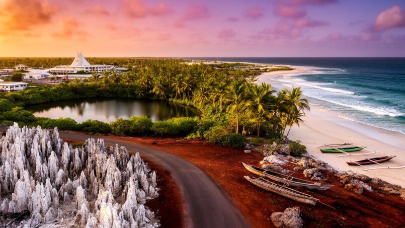
Anibare Beach, stretching over two kilometers, is the longest uninterrupted beach on the island. It is also, according to most visitors and locals alike, the most photogenic. The light sand contrasts with a sea ranging from emerald green to deep turquoise, dotted with coral rocks sculpted by erosion, sometimes forming true “pinnacles” over two meters high that rise from the sand. At low tide, this “forest of rocks” fully reveals itself, offering light and contrast effects that photographers love.
In the morning, the beach is an excellent spot to watch the sunrise, as the east coast faces the Pacific horizon. During the week, the place remains mostly deserted most of the time, offering more the feel of the edge of the world than a seaside resort. You can walk along the curve of the shore, swim at high tide, improvise a picnic in the shade of palm trees, or simply watch the waves.
However, the sea is not always forgiving. The surf can be powerful and rip currents have been reported. Locals recommend entering the water only at high tide, wearing reef sandals due to sharp corals, and favoring protected areas.
Anibare Harbour, the Living Heart of the Coastline
At the southern end of the bay lies Anibare Harbour, an artificial fishing port built in 2000. Protected by high stone breakwaters, it serves both as a base for the local fishing fleet and as the main safe swimming spot for families. The bottom is more even, without large sharp coral blocks, making it pleasant for swimming, especially in the late afternoon when the heat subsides and locals come to cool off.
The port is an ideal place to immerse yourself in local life: you can watch the boats leaving at dawn, the fishing returns, the unloading of fresh fish, and animated discussions on the docks. For enthusiasts, deep-sea fishing trips are organized by operators like Equatorial Gamefishing Charters, allowing you to explore a Pacific area known for its abundance of fish.
One unique feature of the port is a designated swimming area, partially enclosed by walls and supervised by lifeguards called “Nauru Life Guards.” This facility, supported notably by refugees on the island, allows children to swim and fish sheltered from the waves and currents.
Anibare Bay, Facts and Impressions
The table below summarizes some data and perception elements about this key site.
| Element | Detail |
|---|---|
| Location | East coast, Anibare district |
| Beach length | > 2 km |
| Sand type | Fine white sand |
| Water color | Turquoise, emerald, very clear |
| Main activities | Swimming (high tide), walking, picnicking, snorkeling, fishing |
| Crowds | Low, calm atmosphere |
| Hazards | Strong waves and possible rip currents |
| Facilities | Fishing port, supervised swimming area, a few restaurants |
| Average rating (platform) | 4.3/5 “bubbles,” with majority of “Excellent” and “Very good” reviews |
| Distinction | Ranked #1 activity in Anibare on a major travel review site |
Beyond the beach itself, the wooded escarpment overlooking the bay has been classified as an “Important Bird Area” covering about 35 hectares. It is home to the Nauru reed warbler, an endemic species, black noddies, and potentially the rare Micronesian imperial pigeon. Birdwatchers see it as one of the few significant avian refuges on an island largely disrupted by mining.
Services and Atmosphere Around the Bay
The Anibare coastline concentrates several services useful for travelers. The Menen Hotel, one of the few large island establishments, is nearby, as is Hotel Nauru. On the dining front, The Bay Restaurant stands out with a menu blending Indian, Western, and Indo-Fijian cuisine, served by a mostly Fijian team known for its warmth. Several local Chinese restaurants and takeaway options round out the offerings, with a more upscale establishment across the road for those seeking a nicer setting.
Despite the absence of beach bars and lively nightlife, characterized by quiet evenings, a resort project (Anibare Beach Resort) was approved in 2021 to develop the tourist potential of the area, while for now maintaining a spirit far removed from large beach resorts.
Other Beaches Not to Miss
While Anibare dominates the imagination, other coves are worth leaving the main road for. On such a small island, each beach has its own personality, often marked by a lack of facilities and tranquility.
Anabar Beach, the Wild Extension North
North of Anibare, the coast continues toward the Anabar district. Walking or cycling about ten minutes along the shore brings you to Anabar Beach, sometimes called Anabari Bay. Here, the atmosphere is even more isolated: a long strip of pristine white sand, crystal-clear turquoise water, and very few visitors.
Like at Anibare, coral pinnacles emerge from the water, giving the landscape an otherworldly feel. It’s a pleasant spot for those wanting to immerse themselves in an almost untouched vision of Nauru’s shoreline, without buildings or vehicle noise. The lack of services means you need to come self-sufficient: no cafés, no toilets, no shops.
Western Bay, Meneng, and Family-Friendly Beaches
On the southwest coast, in the Boe district, Western Bay offers a gentler side of the ocean. This large sandy beach, fringed by shallow, calm water, is considered safe for swimming. The waves are less rough than on the east side, making it a natural refuge on days with swell.
Further east, near the Menen Hotel, another stretch of beach is often described as ideal for lazing around: comfortable sand, pleasant sea breeze, relatively calm sea. The clear waters allow for accessible snorkeling, especially for beginners, with patches of reef easily reachable from the shore.
In the Meneng district, Ataro Bay Beach also stands out for its shallow, clear waters, lined with palm trees. Popular with locals rather than tourists, it is almost never crowded. Like other stretches of coastline, no facilities are installed here: you come with your cooler, mat, and sunscreen.
Chad Park Beach, Ewa Beach Park, and the North Coast
To the north, Chad Park Beach, in the Anetan district, offers a long ribbon of white sand, backed by a fringe of trees that provide welcome shade midday. The spot is good for picnics, quiet walks, and a few dips in clear water. But there are no shops or restaurants nearby, so come prepared.
Located opposite the Capelle & Partners complex (the island’s biggest supermarket, café, bakery, shops), this park offers shaded farés. Although its beach is not the most beautiful, it’s a practical spot to combine shopping, a coffee break, and a sea view.
Nauru’s Beaches at a Glance
To better understand the diversity of the coastline, the following table compares several major beaches.
| Beach / Bay | District | Main Characteristics | Nearby Facilities | Recommended Use |
|---|---|---|---|---|
| Anibare Bay | Anibare | Long white sand beach, coral rocks, turquoise water, sunrise | Port, restaurants, hotels | Swimming (high tide), photos, fishing |
| Anabar Beach | Anabar | Isolated beach, pristine sand, crystal-clear water, coral pinnacles | None on site | Walks, contemplation, solitude |
| Western Bay | Boe | Large beach, shallow and calm water | Very few services | Safer swimming, families |
| Menen Hotel Beach | Meneng | Comfortable sand, calm sea, easy snorkeling | Menen Hotel (accommodation, shop) | Bathing, beginner snorkeling, relaxation |
| Ataro Bay Beach | Meneng | White sand, palm trees, gentle waves | None on site | Tranquil swimming, local atmosphere |
| Chad Park Beach | Anetan | Long beach, shaded trees, clear water | None on site | Picnic, walk, light swim |
| Ewa Beach Park | Ewa | Palm trees, picnic shelters, average beach | Capelle & Partners (supermarket, café) | Convenient break, Sunday outing |
| Yaren Beach | Yaren | Beach near official buildings | Yaren district services | Evening relaxation |
Overall, the best time to enjoy the beaches is during the dry season, between May and October, when the sea is more predictable and the heat, though constant, is a bit less oppressive.
Buada Lagoon, Inland Oasis in the Heart of the Plateau
Away from the coast, Nauru hides a completely different face: that of Buada Lagoon, the island’s only true body of freshwater. Nestled in a karst depression in the southwestern part of the central plateau, this oval lake of about 3.8 hectares contrasts sharply with the surrounding mining landscapes.
The water body, slightly brackish, is shallow – around two meters on average, peaking at five meters after heavy rains. It has no connection to the sea, making it an endorheic lake fed solely by rainfall. Around it, dense tropical vegetation occupies the waterlogged soils: coconut palms, banana trees, pandanus, breadfruit trees, mangoes, guavas, soursops… This green belt is one of the few still fertile agricultural areas in a country where most arable land was sacrificed to phosphate mining.
The Arenibek neighborhood surrounding the lake is the only true inland settlement, with about 660 residents. Their houses are scattered among the trees, giving the site an intimate, almost village-like feel, far from the coastal strip where most of the population lives.
A Nourishing Past, a Fragile Present
For centuries, Buada Lagoon played a central role in local subsistence. Nauruans practiced fish farming there, notably raising milkfish, which provided a significant part of the island’s diet. This activity was abandoned in the 1960s, before more recent attempts at revival.
The lake currently has poor water quality, characterized by the spread of invasive plants (water hyacinth) and algae, presence of litter, and unpleasant odors. Authorities advise against swimming, a view shared by visitors who find the place ‘not swimmable.’ The protection of the shores by unattractive metal guardrails underscores the concerning state of this precious site.
Despite this, Buada Lagoon continues to host interesting wildlife. Various fish species are found, including milkfish, tilapia, and introduced gambusia, as well as a number of birds, notably the Nauru reed warbler. The presence of this endemic species, threatened by habitat loss, gives the site undeniable ecological value.
Visiting Buada Lagoon: Calm, Morning Light, and Caution
From a visitor’s perspective, Buada Lagoon is not a site to “do” like checking off an amusement park attraction, but rather a place to feel. Most accounts mention a short stop, enough to walk along the shore, take a few photos of the reflections at sunset, or enjoy the relative coolness provided by the trees.
The best time for a visit is early morning, for the soft light and bird activity. It’s essential to bring water, a snack, good walking shoes, and a powerful mosquito repellent. Perceptions of the place vary: some see a peaceful haven, others a damaged landscape, depending on one’s sensitivity to environmental issues and contrast with the rest of the island.
On a practical note, access is either by vehicle, via a road climbing inland from Aiwo or Ewa, or on foot for the more motivated: a walk of twenty to forty minutes depending on the starting point, sometimes along former phosphate installations.
To sum up, Buada Lagoon remains an unmissable site less for swimming – not recommended – than for what it tells us: the Nauru before phosphate, the resilience of a few pockets of greenery, and the tension between memories of abundance and present-day reality.
Topside, Command Ridge, and the Scars of World War II
It’s hard to talk about Nauru’s tourist sites without mentioning its central plateau, the famous “Topside.” This area, covering about 80% of the land surface, was systematically strip-mined to extract tens of millions of tons of phosphate. The result is a landscape of sharp limestone pinnacles, stripped of soil, often described as lunar or post-apocalyptic.
Hidden within this scenery are several major sites for those interested in military and industrial history: Command Ridge, Japanese cannons, old tunnels, the jungle jail, and remains of the phosphate railway.
Command Ridge, the Roof of the Island and Japanese Observation Post
At 60 to just over 70 meters in elevation depending on sources, Command Ridge is Nauru’s highest point. The ascent is usually by vehicle via interior roads, followed by a short walk. At the top, the panoramic view gives a sense of the island’s small size: the sea appears in all directions, the coastal strip clearly distinct from the mining plateau bristling with rock spires.
During the Japanese occupation, this promontory was a nerve center. Traces remain of a command post, including half-buried concrete bunkers, remnants of a communication station, and rusted cannons facing seaward. One of these cannons, famous among fortification enthusiasts, has visible bulges near the top of the barrel. A gallery dug nearby allowed access from inside.
The site is now largely left as is, overgrown with vegetation in places, with little staging. A local guide is highly recommended to spot the most interesting relics and understand the strategic role of this hill in the Japanese setup.
Cannons and Bunkers Scattered Around the Island
Beyond Command Ridge, World War II left its mark in many corners of Nauru. At least three large Japanese cannons remain on the island, some perched amid the pinnacles of Topside. One of them, accessible via a bumpy trail winding through the rocks, requires some agility but offers, at the end, a striking face-to-face with a piece of artillery frozen in rust.
Several WWII remnants survive on Nauru. Cannons are hidden near the Menen Hotel and the airport. At Yaren, a cannon still overlooks the cliff as a symbolic coastal defense post. You can also find ‘pillboxes’ (concrete casemates), often tagged and filled with trash, which offer tangible evidence of the island’s fortress past.
The table below summarizes some main locations related to war relics.
| Site / Relic | Approximate Location | Features |
|---|---|---|
| Command Ridge | Interior, near west-central | Highest point, bunkers, cannons, former communication center |
| Topside Cannon | Central plateau | Accessible by trail amid pinnacles, rusted cannon |
| Cannons near Menen Hotel | Meneng district | Japanese coastal batteries |
| Cannon near airport | Near INu | Hidden location in tall grass |
| Japanese bunker at Anabar | Anabar district | Pillbox on a rocky spur, accessible by jungle trail |
| Coastal bunkers at Yaren | Yaren cliffs | Defense positions facing the reef |
Access to some of these sites crosses private land or unsafe areas. Again, the help of a guide, or at least permission from residents, is essential, if only to avoid getting lost in the labyrinth of unmarked tracks.
The “Jungle Jail,” Japanese Prison Buried in Vegetation
Among the most striking relics is a small Japanese prison from wartime, sometimes called the “jungle jail.” Nestled not far from the road to Buada Lagoon, it consists of three isolated cells, built to imprison opponents and prisoners of war.
To reach this site, leave the main road and look for old rails hidden under the sand. Then enter a narrow vegetal corridor where lianas and trees encircle rocky blocks. This trail, though beautiful, is heavily infested with mosquitoes. At its end, the mossy concrete walls of the prison, partially swallowed by the jungle, appear. The place is neither developed nor lit, so a flashlight, sturdy shoes, and repellent are absolutely essential.
This prison gives a human dimension to the story of the Japanese occupation, reminding us of the coercive use of the island, beyond the mere fortifications.
Industrial Relics of Phosphate
The Topside is not just about the war period: it above all tells a century of dependence on phosphate. Besides the pinnacles themselves, which testify to the disappearance of soil and vegetation, several industrial elements are still visible: narrow-gauge railway lines dating from 1907, old locomotives, rails leading to the loading jetties at Aiwo, crushing facilities, or conveyor structures on stilts.
The rail network, about 3.9 kilometers long, transported ore from the interior to the loading structures on the west coast. Today, some sections are no longer used, but they serve as an ideal guiding thread for anyone wanting to understand how this mineral shaped the island’s economic destiny – and subsequent crisis.
Informal tours to mining areas and abandoned infrastructure can be arranged through accommodations or local contacts. This type of visit is more akin to “industrial exploration” than a classic excursion: it requires sensitivity to the degraded environment, but also an awareness that these landscapes are at the heart of Nauru’s contemporary identity.
Yaren, Political Showcase and Gateway to the Island
Yaren is not officially a capital, but it concentrates most functions of a seat of government: Parliament, ministries, airport, main public services. For a traveler, it serves as arrival point, logistical base, and a place to grasp some keys to understanding the country.
Between Planes, Institutions, and the Seaside
Nauru International Airport, one of the smallest in the world, sits by the sea, with the runway literally cutting across the ring road. The only traffic lights in the entire country serve to temporarily stop cars when planes land or take off. For visitors, photographing this moment when an aircraft crosses the road is almost a ritual.
Nauru’s Parliament, a symbol of phosphate-driven prosperity, was built at the beginning of this decade.
Still in Yaren, you’ll find most essential services: post office, general hospital, fire station, police station, library, immigration office, government agencies, and schools. All these points make the district unavoidable, if only for a few formalities or inquiries.
Museums, Memorials, and Daily Life
Yaren also houses the island’s main museum, sometimes called Naoero or Nauru Museum, located in a former administrative building. For a modest entry fee, visitors discover pre-colonial tools, photos from the phosphate era, objects evoking German, Australian, and Japanese occupations, as well as panels explaining the ecological upheaval of Topside. This small museum often provides the best structured introduction to the island’s history.
A modest but important memorial pays tribute to Nauruans who died during the war. A wall bears the names of the missing, particularly those deported to the Truk Islands (Chuuk). It is a significant place of remembrance for the local population.
In daily life, Yaren also pulses to the rhythm of Australian football matches at Linkbelt Oval, training sessions of the national weightlifting team – a sport where Nauru has often shone internationally – or services at various churches, numerous on such a small area. For a curious visitor, it’s the place where the country’s major issues (economy, climate, public health) intersect with the ordinariness of office life, school lessons, and market shopping.
Moqua Caves and Moqua Well, Yaren’s Hidden Underground
A few steps from this institutional facade lies another world: the Moqua Caves, a network of limestone caverns hidden beneath the Yaren district. They are accessed through relatively discreet openings, and exploration should only be undertaken with a local guide, both for safety reasons and out of respect for sometimes sensitive sites.
The underground lake Moqua Well, at the heart of the island’s cavities, was Nauru’s main freshwater source. This reserve illustrates the island’s historical dependence, lacking rivers, on its rare freshwater pockets before the development of desalination and rainwater harvesting systems.
This site, more physical than average, requires closed-toe shoes, a headlamp, and no claustrophobia. Depending on current conditions and local policy, some galleries may be closed or discouraged: checking with guides remains essential.
Aiwo, the Phosphate Port and Witness to Past Prosperity
On the west coast, the Aiwo district houses the main phosphate export port. Large metal installations – conveyors, pylons extending into the sea, warehouses – compose a surprising industrial landscape in an island setting. Here, tens of millions of tons of ore left the island, enriching farmers in Australia, New Zealand, and the UK at the time, but leaving behind a damaged land.
The port area offers a concrete vision of the economic system that made the country one of the richest in the world in GDP per capita. This prosperity, tied to natural resource extraction, vanished with the depletion of deposits, causing the accumulated wealth to evaporate.
Aiwo is also home to some old infrastructure, such as sections of the 1907 railway, or old technical buildings. Nearby, establishments like Ewa Lodge (to the north, in Ewa, but on the same road axis) or Od’n Aiwo Hotel (long a landmark, now closed pending possible renovations) have served and continue to serve as bases for many travelers on professional or tourist missions.
Tourism of Experiences Rather Than “Must-Sees”
Behind this list of sites, what strikes you about Nauru is the very “raw” nature of tourism. The island has neither amusement parks, nor rows of resorts, nor marked circuits with explanatory signs at every corner. Many points of interest – a bunker lost in the vegetation, a rock overlooking the sea, a railway relic or phosphate kiln – remain invisible without the help of a local who knows the area well.
Visiting the island presents challenges like equatorial heat, mosquitoes, unpaved roads, and lack of signage. However, its small size allows you to tour it in a few days: plan one day for the east coast (Anibare, Anabar, Meneng), another for the interior (Buada Lagoon, Command Ridge, the Japanese prison, the mines), and a final day for Yaren, the Moqua Caves, the port of Aiwo, and the coves of the north and west.
Key Activities, Contexts, and Constraints
Rather than multiplying lists, we can outline a few broad types of possible experiences, linking them to the key sites already mentioned.
Swimming and snorkeling are mainly concentrated around Anibare Bay, Anabar, Western Bay, and the beaches of the Menen Hotel. Although the reef surrounds the island, safe passes are limited and currents can be dangerous. It is crucial to ask locals about swimmable areas, never swim alone, and keep in mind the absence of a formal lifeguard system on most beaches.
On the nature side, the coastline offers hidden coves, tide pools on the east coast, spectacular cliffs near Egu, as well as viewpoints over the ocean in the northwest, known for their sunsets. Inland, Buada Lagoon and the surrounding micro-forest of tamanu form a rare and precious green corridor, paired with a more humid microclimate.
Finally, history is omnipresent: World War II relics at Command Ridge, Yaren, Anibare, Anabar; phosphate infrastructure at Aiwo and on Topside; museum and memorials at Yaren. These sites tell both the story of colonial resource exploitation and the island’s strategic position in the Pacific.
Practical Tips for Exploring Nauru’s Sites
Even though the aim here is not to detail all visa or logistics questions, a few elements directly influence how you access tourist sites.
First, the ring road of 19–21 kilometers theoretically makes it possible to walk around the entire island in five to six hours, cycle it in two to three hours, or drive it in just over half an hour. In practice, the heat and lack of shade over long stretches encourage splitting up explorations and using taxis, rental vehicles, or bicycles.
The island’s road network extends about 30 km. It includes paved roads as well as unpaved tracks leading inland, for example to Buada Lagoon or mining areas. These tracks can become difficult to access, especially after heavy rains, and sometimes require a sturdy vehicle or a 4×4.
The lack of street lighting outside a few urban areas also requires planning visits to less frequented sites during the day rather than in the evening. On most beaches, there are neither lifeguard stations nor indications of sea conditions: common sense and local recommendations remain the best safeguards.
Finally, accommodation options are concentrated in a few hotels and lodges, including Menen Hotel (government-owned), Ewa Lodge, or other private units. Reservations must be made well in advance given the small number of available rooms.
An Island-Laboratory of the Relationship Between Tourism, History, and Environment
Nauru is not a mass tourism destination, and the country has not yet chosen to make tourism its economic pivot. Given the fragility of its ecosystems, the narrowness of its habitable coastline, and the scars of phosphate mining, tourism development is a delicate balance.
Projects like the “Anibare Beach Resort” or Topside restoration initiatives, driven by rehabilitation programs and climate finance, sketch a possible reconversion where beaches, bird reserves, historical sites, and even mining landscapes could become resources not extracted but interpreted. In that future, Nauru’s “must-see” sites would not just be places to photograph, but chapters in a global story: that of an atoll long called “pleasant island,” passing in a century from extreme prosperity to environmental crisis, and now facing rising sea levels.
Nauru’s redevelopment projects
For the traveler willing to accept these contradictions, to walk in the heat and give up the comfort of a codified tourist offer, Nauru offers a unique field of exploration. Anibare Bay, Buada Lagoon, Command Ridge, Yaren, the Moqua Caves, the Anabar bunkers, or the port of Aiwo then become so many milestones for understanding what it means to inhabit, transform, and attempt to reinvent a 21 km² territory lost in the middle of the Pacific.
Disclaimer: The information provided on this website is for informational purposes only and does not constitute financial, legal, or professional advice. We encourage you to consult qualified experts before making any investment, real estate, or expatriation decisions. Although we strive to maintain up-to-date and accurate information, we do not guarantee the completeness, accuracy, or timeliness of the proposed content. As investment and expatriation involve risks, we disclaim any liability for potential losses or damages arising from the use of this site. Your use of this site confirms your acceptance of these terms and your understanding of the associated risks.

Cyril Jarnias is an independent expert in international wealth management with over 20 years of experience. As an expatriate himself, he is dedicated to helping individuals and business leaders build, protect, and pass on their wealth with complete peace of mind.
On his website, cyriljarnias.com, he shares his expertise on international real estate, offshore company formation, and expatriation.
Thanks to his expertise, he offers sound advice to optimize his clients' wealth management. Cyril Jarnias is also recognized for his appearances in many prestigious media outlets such as BFM Business, les Français de l’étranger, Le Figaro, Les Echos, and Mieux vivre votre argent, where he shares his knowledge and know-how in wealth management.





