
 Published on and written by Cyril Jarnias
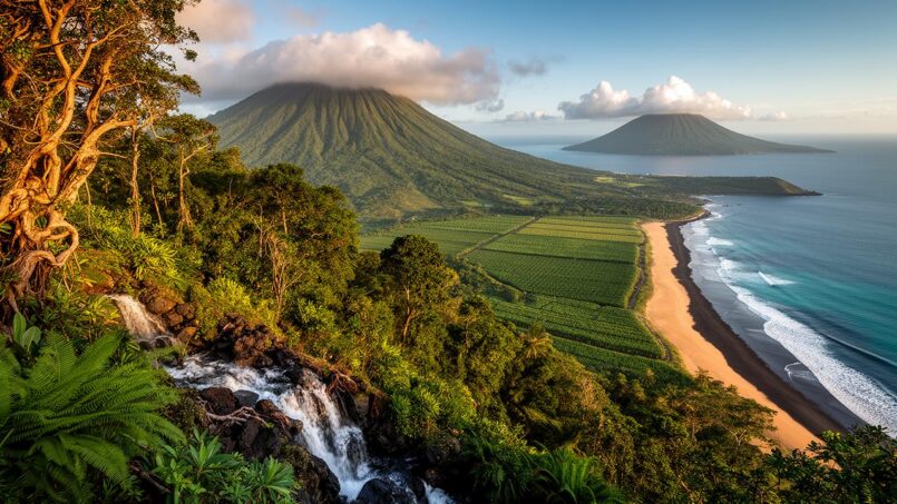
Lost in the middle of the Caribbean Sea, the geography of St. Kitts and Nevis is a tiny nation in size, but a concentrate of volcanic landscapes, microclimates, contrasting coastlines, and fragile ecosystems. To understand this territory is to grasp the logic of an archipelago born of fire, surrounded by the ocean, and now facing climate challenges head-on.
A Tiny State at the Heart of the Lesser Antilles
The geography of St. Kitts and Nevis is a federation of two main islands, St. Kitts and Nevis, set within the arc of the Lesser Antilles. They belong to the Leeward Islands subgroup, in the eastern Caribbean Sea, where the Atlantic plate subducts beneath the Caribbean plate.
The total area of St. Kitts and Nevis is approximately 261 km², making it one of the smallest countries in the world.
Located about one-third of the distance between Puerto Rico and Trinidad and Tobago, the islands are situated more than 2,000 km southeast of Miami. They are bathed by the Caribbean Sea but face the Atlantic on their eastern side, with a whole string of neighbors in the background: Saba, St. Eustatius, St. Barthélemy, and St. Martin to the north-northwest; Antigua and Barbuda to the northeast; Montserrat and Redonda to the southeast.
A Landscape Born from an Active Volcanic Arc
Like most of the Lesser Antilles, the geography of St. Kitts and Nevis is the product of subduction: as it sinks beneath the Caribbean plate, the Atlantic plate has created a volcanic arc whose islands are merely the emerged peaks of a submarine mountain chain.
The archipelago is geologically young. Its formation began less than 50 million years ago (Miocene), with volcanic activity until recently. St. Kitts is composed of andesitic and dacitic volcanic rocks, typical of subduction arcs. Nevis, even younger, began forming around 3.45 million years ago (mid-Pliocene) around several eruptive centers.
The two islands are part of what geologists call the “Volcanic Caribbees”, dominated by volcanic edifices and deposits from the Pleistocene. The main volcanoes, now dormant but considered potentially active, remain at the heart of the landscapes and natural hazards.
Two Islands, Two Volcanic Silhouettes
For such a small state, the variety of landforms is striking. St. Kitts develops along a northwest/southeast axis, with a long central mountainous backbone, while Nevis adopts an almost circular form dominated by a central cone.
St. Kitts: A Mountainous Backbone and an Arid Peninsula
St. Kitts stretches about thirty kilometers long, with an average width of 8 to 10 km. Three major volcanic groups structure its relief:
– To the northwest, the Mount Liamuiga massif, the highest point in the entire country at 1,156 m;
– In the center, the Middle Range (or Central Range), reaching nearly 975 m;
– Further southeast, an older range, the South East Range, with peaks plateauing around 900 m.
These three groups form a true backbone that crosses the island, surrounded by steep slopes, deep ravines – the famous ghauts – and a narrow coastal strip where most of the urbanization and farmland are clustered.
At the southeastern tip of the island, the landscape becomes a narrow peninsula, sometimes only a few hundred meters wide, formed by islets connected by sandbars. The relief consists of rounded hills rarely exceeding 300 m in altitude, interspersed with depressions and salt ponds like the Great Salt Pond, the island’s largest body of water. The vegetation, adapted to a drier microclimate, consists mainly of grasses, thorny shrubs, cacti, and yuccas.
Around these reliefs, the coastline is extremely contrasted. St. Kitts has approximately 78 km of coastline, composed of volcanic escarpments, black sand beaches, and ribbons of golden sand. The Atlantic coasts, exposed to dominant swells, feature high rocky cliffs and narrow coves. To the west, on the Caribbean side, the profile is gentler, with more accessible beaches.
A coastal inventory shows the diversity of St. Kitts’ shores:
| Type of Coast on St. Kitts | Approximate Length |
|---|---|
| Rocky Cliffs | 34.7 km |
| Pebble (Cobble) Beaches | 10.8 km |
| Rocky Boulders / Scree | 6.3 km |
| Black Volcanic Sand Beaches | 13.1 km |
| Golden Sand Beaches | 13.2 km |
The cliff-backed beaches are often narrow, made of coarse dark sand mixed with pebbles. A few exceptions in the northwest offer lighter sand and wider beaches. East of Basseterre, however, the coast unfolds long stretches of fine yellow sand, notably towards Frigate Bay, South Friars Bay, Cockleshell Beach, or Banana Bay.
Nevis: An Almost Perfect Cone Set on the Sea
Nevis, much more compact, appears on the map as a green disk 12 km long by less than 10 km wide. A single large edifice, Nevis Peak, dominates everything, peaking at nearly 985 m. It is a Pelean-type volcano, whose flanks have been shaped by the accumulation of lava domes, pyroclastic flows, lahars, and debris avalanches.
Around the main summit, a chain of hills forms a northwest/southeast spine. The slopes become extremely steep, exceeding 40%, notably around Saddle Hill, Butlers Mountain, and Nevis Peak, before gentling towards the coastline.
Geologists have identified several distinct volcanic centers on Nevis: Hurricane Hill, Round Hill, Cades Bay, Saddle Hill, Red Cliff, Butlers Mountain, and Nevis Peak. The oldest, Hurricane Hill or Round Hill, date back up to 3.4 million years. The most recent, including Nevis Peak, date from about 1 million to 100,000 years ago, which is extremely recent on the geological time scale.
Unlike its neighbor, Nevis is characterized by mostly sandy and light-colored beaches, formed by the erosion of reefs and coral deposits. The famous Pinney’s Beach, north of Charlestown, stretches for nearly 4 km with yellow sand from coral fragments mixed with mainland soils. Other notable coves like Oualie Beach, Mosquito Bay, or Cades Bay also dot the island’s coastline.
Here, sea cliffs are concentrated more on the south and east sides, where the sea cuts into rocky platforms. Freshwater lagoons have formed behind some beaches, fed either by mountain runoff (as in the Pinneys Estate lagoons) or by groundwater resurgence (Nelson Springs source, near Cotton Ground).
A Tropical Climate, Hot, Humid, and Rhythmed by the Trade Winds
Located near the Tropic of Cancer, St. Kitts and Nevis enjoys a tropical maritime climate, regularly ventilated by the northeast trade winds. Temperature variations throughout the year are limited, but the seasons are marked by the alternation between drier periods and a wet phase, coupled with a high hurricane risk.
Stable Temperatures Year-Round
Across the territory, average temperatures hover around 26 to 27°C. In the capital Basseterre, at sea level, the daily average generally oscillates between 25.5°C in January-February and about 28°C between June and October. Maximums rarely exceed 32°C, while minimums almost never drop below 18°C.
Nevertheless, the country experiences two distinct thermal periods. The “cool season,” from December to March, corresponds to the least hot months, with more pleasant nights. The “hot season,” from May to October, coincides with the highest temperatures and often oppressive humidity. During this period, on average, there are more than fifty days with maximums above 32°C, and about thirty nights where the temperature does not drop below 26°C.
Altitude moderates climatic conditions: beyond a few hundred meters, evenings are cooler and mist more frequent. For example, Nevis, overall higher, enjoys slightly lower temperatures than St. Kitts.
Rainy Seasons, Droughts, and Hurricanes
Precipitation, as often in tropical zones, falls as brief and intense showers or thunderstorms, with strong spatial and temporal disparities. The archipelago does not have a rainy season as pronounced as in a monsoon climate, but a distinctly wetter period can be identified.
On St. Kitts, the average annual rainfall is around 1,400 mm, but varies depending on slopes exposed to the trade winds and altitudes. Nevis receives on average a bit less rain, about 1,170 mm per year, while the more arid southeastern peninsula of St. Kitts can remain under 1,000 mm annually. For the entire country, climate statistics indicate averages between 40 and 60 inches of water depending on the sector, i.e., 1,000 to over 1,500 mm.
The climate is divided into two main seasons: the dry and cool season from December to April, and the wet season from May to November, which corresponds to the Atlantic hurricane season. The risks of storms and hurricanes increase significantly from July to November, with a peak of danger usually between August and September.
In Basseterre, rainfall data shows a minimum between January and April, where monthly totals do not exceed 70 mm and the number of rainy days is around 8 in April. From July to December, accumulations most often exceed 100 mm per month, with a maximum of rainy days in November (around 15 rainy days). Over the year, there are on average one hundred to 150 days with measurable precipitation.
The mountains capture a significant share of the moisture: the highlands can receive over 3,000 mm per year, fostering dense forests and a network of torrential rivers. Conversely, the leeward slopes and some peninsulas experience much more modest rainfall regimes, with marked drought episodes.
In addition to the natural climate variability, there are extreme hazards. Periods of seven days without rain can occur in any season, especially from January to May. Severe droughts, affecting water resources and agriculture, occur on average every 4 to 5 years during the dry season. Conversely, exceptional rains can cause flash floods in the ravines, mainly from April to May and September to November.
Humidity, Sunshine, and Sea Temperature
The average relative humidity remains high, often around 70 to 75% over the year. At some measuring points, it oscillates from 77% in February to over 80% in July. The summer months, hotter, are also the most humid, which increases the feeling of heat.
Despite these sometimes oppressive conditions, the archipelago enjoys excellent sunshine, close to 3,000 hours per year, i.e., about 8 to 9 hours of daily sunshine on average. The months at the end of the dry season – February to April – are particularly bright, with clear sky rates that can exceed 70% in some sectors.
Daylight also varies with latitude: day length oscillates between about 11 hours in December and 13 hours in June, without great seasonal amplitudes.
As for the sea, swimming is possible year-round. The average water temperature is around 27.5°C, with a minimum around 26°C in late winter (February-March) and a maximum close to 29°C at the end of summer (August-October). This thermal consistency, combined with water clarity and reef richness, makes St. Kitts and Nevis a sought-after destination for diving.
Mountains, Ravines, and Water Resources
The interior of the two islands, steep and difficult to access, directly conditions hydrology, forest distribution, and human settlement. The vast majority of inhabitants – over 60% – live in coastal zones, leaving the mountainous heart largely preserved, but also exposed to landslides and erosion.
Mount Liamuiga and Nevis Peak: Two Volcanic Sentinels
The highest point in St. Kitts and Nevis is Mount Liamuiga, on St. Kitts, peaking at 1,156 m. Formerly named Mount Misery, this morphologically young volcano dominates a large part of the island. Its summit crater, about 1 km in diameter and over 200 m deep, contains a small depression that can collect rainwater. The volcano’s flanks are cut by deep ravines where pyroclastic deposits, mudflows, and debris avalanches accumulate.
This is the altitude in meters of Nevis Peak, the volcano that dominates the island of Nevis.
These two edifices, as well as other older volcanic centers, are now considered dormant. They have not experienced a documented historical eruption, but field studies and deposit chronology show they remain potentially active. Associated risks range from ash emission and pyroclastic flows to lahars, i.e., volcanic mudflows rushing down slopes during heavy rains.
Ephemeral Rivers and Strategic Aquifers
The abundance of relief and rainfall intensity give rise to many watercourses, but few flow year-round. Most rivers and ghauts only fill up significantly during the wet season or during violent thunderstorms.
On St. Kitts, drainage follows a radial pattern: water flows from the central range towards the sea, interrupted only by secondary volcanic cones. Rivers like Wingfield or Cayon sometimes reach the ocean during very wet periods, but many beds remain dry most of the time. These ravines are nonetheless essential: they transport sediments and nutrients to the coast, form flood channels, and represent pathways for groundwater flow.
Nevis presents a similar system, with ten major drainage basins radiating from Nevis Peak. Watercourses such as Camps River, Barns Ghaut, or Kitt Ghaut feed ephemeral beds. The major exception is the Bath Stream, fed by springs located less than 2 km inland, which flows continuously to the sea.
Freshwater supply depends mainly on groundwater aquifers. In Nevis, it relies on shallow coastal aquifers and two deep aquifers. In St. Kitts, it comes from five major basal aquifers, supplemented by some surface water catchments. On both islands, rain is the only recharge source, making the role of mountain forests crucial for promoting infiltration and limiting runoff.
The vulnerability of this resource is a major geographical issue. The country is already classified as experiencing water scarcity. Observed trends – a decrease in average rainfall on the order of 47 mm per decade since the 1960s – and climate projections – a possible decrease of 3 to nearly 50% in rainfall during the 21st century – foreshadow increased pressure on aquifers. The rise in sea level, estimated between 30 cm and over one meter by 2100, simultaneously increases the risk of saltwater intrusion into coastal aquifers.
To compensate, rainwater harvesting and seawater desalination projects, notably supported by international partnerships, are becoming increasingly important in territorial planning.
Coasts, Reefs, and Coastal Landscapes
With 135 km of shoreline for only 261 km², St. Kitts and Nevis, like many small island states, is highly “coastal.” The majority of the population, infrastructure, and economy are concentrated a few meters above sea level, bordering beaches, reefs, or lagoons.
Black, Yellow, and Silver Beaches
The contrast between the two islands is evident from the sand. On St. Kitts, most beaches rest on a volcanic substrate: the sand is dark, almost black in places, composed of basaltic and andesitic grains from the erosion of interior rocks. At the foot of volcanic cliffs – notably on the northwestern side – these beaches are narrow, pebbly, and churned by Atlantic waves.
Closer to the southeastern peninsula, the color lightens: the large coves of Frigate Bay, South Friars Bay, or Cockleshell display golden hues, nourished by the input of lighter sediments and the presence of fringing reefs. Basseterre, the capital, is bordered by a narrow beach of gray sand, squeezed between the wharves, the city, and the sea.
Pinney’s Beach, the main beach of Nevis, stretches for about 4 kilometers of light-colored sand.
Reefs, Seagrass Beds, and Mangroves: A Living but Fragile Coastline
Beyond the sand, the coastal geography of St. Kitts and Nevis is organized around three main habitats: coral reefs, seagrass beds, and mangroves, to which salt ponds and lagoons are added.
Reefs particularly surround Nevis and the more sheltered coasts of St. Kitts. They harbor remarkable biodiversity, with corals, tropical fish, sea turtles, and invertebrates like lobster and conch. Some studies estimate these reefs can support up to 48 tonnes of fish per km², an essential ecological capital for artisanal fishing and dive tourism. St. Kitts is regularly cited among the major diving destinations in the Caribbean.
Seagrass beds stabilize sediments, reduce wave energy, and serve as nurseries. Mangroves, for their part, filter pollutants and constitute a natural barrier against storms.
Freshwater or brackish lagoons, like those at Pinneys Estate on Nevis or the Great Salt Pond on St. Kitts, constitute transitional environments where runoff water, groundwater infiltration, and marine influences mix. They harbor birds, juvenile fish, and halophilic vegetation.
Coastal Erosion Amplified by Storms
This coastal fringe is not fixed. Studies conducted after the major hurricanes of the 1990s – notably Luis in 1995 and Georges in 1998 – show how mobile the coasts of St. Kitts and Nevis are. On some Caribbean sites, Luis had caused beaches to retreat by about 28% on average; Nevis particularly suffered on its west coast, very exposed to storm swells.
Work carried out under a regional disaster risk reduction project (PGDM) classified the country’s beaches according to their degree of vulnerability to erosion, from “very low” to “very high.” It reveals a marked asymmetry between the Atlantic and Caribbean sides of St. Kitts.
On St. Kitts, most of the most threatened sites – classified as “very high” or “high” hazard – are located on the Atlantic coast, directly exposed to storm waves, like Sandy Bay, Halfmoon Bay, or Sand Bank Bay. In contrast, many beaches on the more sheltered Caribbean coast show lower erosion rates, or even a tendency towards sedimentation, like Belle Tete, cited as a site with “very low” hazard.
On Nevis, the situation is almost reversed: it is sections of the western coastline, although facing the Caribbean, that show high-risk levels, particularly around certain stretches of Pinney’s Beach (areas called “Pinneys Beach Hotel” or “Pinneys Cotton Ground”). Again, some beaches, like Mosquito Bay in the northwest, show signs of accretion.
The factors at work are multiple: storm swells, storm surges from cyclones, sea level rise, loss of stabilizing vegetation (seagrass, mangroves, dune vegetation), sand extraction, coastal urbanization. As tourist infrastructure – hotels, casinos, marinas – moves closer to the shore, the country’s vulnerability to erosion and marine flooding increases mechanically.
Forests, Ecosystems, and Land Use
For such a restricted territory, the mosaic of ecosystems is surprisingly rich: moist mountain forests, dry forests, shrub savannas, agricultural land, mangroves, reefs. But the balances are fragile, subject to demographic pressure, tourist development, and climate change.
Two Major Terrestrial Ecoregions
St. Kitts and Nevis falls within two recognized major terrestrial ecoregions: the Leeward Islands moist forests and the Leeward Islands dry forests. The former develop on high, well-watered slopes, often shrouded in the mists of Liamuiga and Nevis Peak, where dense rainforests, clouds clinging to the peaks, and lush vegetation are found. The latter colonize lower slopes, drier peninsulas, and some coastal sectors, with more xerophilic flora.
Percentage of the country’s surface covered by forests, a biodiversity reservoir housing more than 150 animal species.
The Forest Landscape Integrity Index, which measures the degree of fragmentation and degradation, however, places the country at a medium-low level (score of about 4.55/10, 121st rank worldwide out of 172). Historical deforestation linked to crops, notably sugarcane and then cotton, and slope clearing for agriculture have broken the continuity of these forests, increasing erosion and the siltation of reefs by sediments.
Land Structuring: Agriculture, Forests, Other Uses
Land use figures shed light on the successive trade-offs between agriculture, conservation, and development.
| Land Use Category (recent values) | Estimated Share of Total Area |
|---|---|
| Agricultural Land (total) | ~23 % |
| – of which arable land | ~19–19.5 % |
| – of which permanent crops | 0.4–2.8 % |
| Permanent Pastures | ~3.5 % |
| Forests | ~42 % |
| Other Uses (urban, fallow, etc.) | ~35 % |
Historically, vast areas of coastal plain on St. Kitts were devoted to sugarcane, the dominant crop until the early 2000s. With the closure of the sugar industry, these lands are gradually being reallocated: some return to diversified agricultural uses, others are coveted for residential, tourist, or infrastructure projects, sometimes without a firmly established planning framework.
Pressure to open new agricultural land on steep slopes, due to growing local food demand, leads to soil erosion, muddy runoff, and pollution of coastal waters by sediments and agricultural inputs, compromising sustainability.
Biodiversity and Iconic Species
Beyond forests, the biological diversity of St. Kitts and Nevis is also illustrated by its birds, marine reptiles, corals, and coastal species. Notably, there is an endemic bird species, the St. Kitts and Nevis bullfinch, adapted to local wooded environments.
Coral reefs harbor rich biodiversity, including threatened corals, multicolored fish, marine mammals, and several species of sea turtles. The health of local fisheries, notably for species like conch and lobster, depends directly on the good health of seagrass beds and reefs.
All these environments are subject to increasing pressures: water pollution from domestic discharges (the country lacks a centralized sewerage system, and a proportion of the population still uses rudimentary latrines), inputs of nutrients and sediments from deforested watersheds, coastal development, introduction of invasive species, not to mention seawater warming and coral bleaching episodes.
Among problematic species, the manchineel tree, extremely toxic, features prominently along some coasts, representing a danger for uninformed walkers. Massive influxes of sargassum, floating brown algae, are added to the list of threats to marine ecosystems and beach tourism.
A Territory Highly Vulnerable to Climate Change
The geography of St. Kitts and Nevis – small, isolated, coastal, mountainous – places it on the front line facing the impacts of global warming. Observations and projections converge towards an aggravation of already perceptible climatic pressures.
Observed Trends and Projections
Climate records indicate a steady increase in average air temperature on the order of 0.11°C per decade. By the end of the century, depending on scenarios, the annual average increase could reach nearly 3°C compared to the late 20th century. In an already hot climate, this drift increases the frequency and intensity of heatwaves.
Precipitation, however, shows a declining trend since the 1960s, with a decrease of about 47 mm per decade. Climate models suggest an overall decrease of 3 to nearly 50% in annual rainfall during the 21st century, combined with greater irregularity: alternation of prolonged droughts and episodes of extreme rain.
At the same time, the sea surface temperature around the islands is expected to continue rising, favoring both coral bleaching episodes and the potential intensification of tropical cyclones.
Nearly 4% of the region’s land is situated less than 5 meters above the current sea level.
Geographical Impacts: Water, Coastline, Agriculture, Forests
Hydrologically, the combination of less precipitation, higher temperatures, and vulnerable coastal aquifers outlines a major risk for drinking water supply. A significant portion of this resource is located beneath the lowest coastal plains, precisely where sea level rise and saltwater intrusions will manifest first. To this are added leaks in the networks – up to more than 50% “non-revenue water” on St. Kitts – and the absence of centralized wastewater treatment, which further weakens aquifer quality.
On the coast, sea level rise and the multiplication of very high swell episodes aggravate erosion, threaten beaches, coastal roads, and hotels, and increase the risk of temporary flooding during storms. Studies highlight the very high concentration of tourist investments “just above” sea level, which, in terms of territorial planning, constitutes a structural vulnerability.
Rain-fed agriculture, predominant on foothills and plains, becomes precarious. By the second half of the century, conditions could be too dry for many crops without irrigation, in a context of water scarcity. In parallel, moist forests risk decreased productivity, changes in composition, or even transformation into drier formations.
Coral reefs, already subjected to thermal stress and the progressive acidification of the ocean, accumulate pressures: turbidity linked to sediment-laden runoff, pollution, bleaching, local overfishing, algae invasions. Yet, their degradation further reduces the natural protection of the coastline against waves and deprives the population of part of its food and tourist resources.
Policy Responses and Territorial Planning
Aware of this geographical vulnerability, St. Kitts and Nevis has undertaken a series of initiatives aimed at “greening” its development model and integrating climate change adaptation into territorial planning. A National Adaptation Strategy, backed by a climate policy adopted in 2017, now guides decisions, notably in the water, tourism, and energy sectors.
Among international commitments, the country updated its Nationally Determined Contribution (NDC) in 2021, committing to reduce its CO₂ emissions by 61% by 2030 compared to 2010. Simultaneously, the stated goal is to move towards 100% renewable electricity generation, whereas today, about 95% of electricity still comes from diesel plants.
The transition involves rapid development of solar and wind power, as well as exploration of the significant geothermal potential of Nevis, identified by its fumaroles, hot springs, and altered zones. Projects for large solar power plants with storage and seawater desalination, sometimes funded by foreign partners, aim to secure energy and water supply.
Legally, a new environmental conservation and management framework has been put in place, with the adoption of a modernized conservation and environment law. Targeted measures, such as the ban on certain single-use plastics and a plastics reduction law, aim to limit marine pollution. In the tourism sector, signing the Glasgow Declaration on Climate Action in Tourism and developing a dedicated climate plan for the sector demonstrate an awareness of the risks weighing on the country’s “landscape capital.”
Finally, several protected areas have been established, notably the Brimstone Hill Fortress National Park (a UNESCO World Heritage Site) and the Central Forest Reserve National Park, which covers the mountainous heart of St. Kitts. Even if the share of protected lands remains modest relative to the entire territory, these designations reinforce the protection of forested peaks, crucial for water resources and biodiversity.
A Geography that Shapes Human Activities
The geography of St. Kitts and Nevis is not limited to its landscapes and climates; it profoundly influences the distribution of the population, infrastructure, the economy, and, ultimately, societal choices.
Coastal Settlement and Sparsely Populated Interiors
Population figures – on the order of 50,000 to 55,000 inhabitants – confirm its status as the smallest sovereign state in the Americas. About three-quarters of the inhabitants live on St. Kitts, where Basseterre, the capital, is located in the southwest, on a relatively sheltered coastal plain.
Most towns – Cayon, Sandy Point Town, Dieppe Bay Town, Middle Island on St. Kitts; Charlestown, Gingerland, Newcastle on Nevis – are strung along the sea’s edge, connected by a road that practically circles each island. The mountainous interior, too steep and difficult to access, remains very sparsely populated, reserved for forests, a few high-altitude farms, and hiking activities.
The territory is structured in concentric circles: forests and peaks in the center, villages and towns on the coast, then the sea. This configuration leads to a dependence on coastal roads for transportation, vulnerability to marine flooding, and difficulties accessing interior resources.
An Economy Dependent on Geographical Assets
If sugar and cane long shaped the landscapes and economy, it is now other geographical characteristics that dominate: beauty of the coastlines, warm climate, warm sea, landscapes conducive to outdoor activities, position in Caribbean shipping routes.
Tourism relies on a set of attractions directly linked to geography: visits to perched fortresses like Brimstone Hill, forest hikes to the craters of Liamuiga or mountain waterfalls, boat excursions to coral reefs, diving, snorkeling, kayaking in mangrove channels, golf at the foot of volcanoes, yachting between St. Kitts and Nevis. Iconic beaches – Pinney’s Beach, Frigate Bay, South Friars – serve as international showcases for this micro-state.
At the same time, the surrounding sea provides fish, crustaceans, and shellfish, although local catches remain insufficient to meet demand and pressure on stocks is increasing. The mountainous topography, fertile volcanic soils, and a hitherto fairly regular climate have also allowed the development of a mosaic of food crops (tubers, vegetables, tropical fruits), although a significant portion of food is still imported.
The limited extent of the territory, however, imposes strong constraints. Flat, well-served areas – notably the former sugar plains and small coastal plains – are in increasing competition between agriculture, housing, industrial zones, road infrastructure, or tourist facilities. Without careful planning, landscape fragmentation increases and natural risks combine: landslides on slopes, sudden flooding in ravines, flooding and erosion on the coast.
Conclusion: An Island Laboratory of Contemporary Geographical Issues
St. Kitts and Nevis brings together, in a minuscule space, an astonishing density of geographical issues. Two volcanic islands perched on a submarine ridge; a double belt of moist and dry forests; coasts with black, golden, or silver sands; fringing reefs and lagoons; a tropical climate tempered by trade winds but threatened by the increasing power of cyclones; a population massed at the water’s edge, between steep mountains and unstable shores.
This territory is at the crossroads of several fault lines: tectonic (seismic and volcanic risk), climatic (rising temperatures, rainfall variability, sea level rise), and socio-economic (extreme dependence on services, tourism, and food imports). Its small size increases its vulnerability, as each hazard impacts the entirety of the available space.
At the same time, this geographical compactness can become an asset. It is easier to envision complete renewable energy coverage, to effectively protect key forest areas for water, to reconfigure land uses, or to monitor a handful of volcanoes and beaches than on the scale of a large country. The question is not so much whether St. Kitts and Nevis is exposed – it clearly is – but how it mobilizes its fine-grained knowledge of the territory to anticipate, adapt, and transform its geographical constraints into levers for more resilient development.
This small island federation illustrates in a visible and immediate way the current tensions between maritime and land development, tourist activity and environmental preservation, and between economic imperatives and climate challenges. Every planning decision there has a direct and rapid impact on the landscape.
Disclaimer: The information provided on this website is for informational purposes only and does not constitute financial, legal, or professional advice. We encourage you to consult qualified experts before making any investment, real estate, or expatriation decisions. Although we strive to maintain up-to-date and accurate information, we do not guarantee the completeness, accuracy, or timeliness of the proposed content. As investment and expatriation involve risks, we disclaim any liability for potential losses or damages arising from the use of this site. Your use of this site confirms your acceptance of these terms and your understanding of the associated risks.

Cyril Jarnias is an independent expert in international wealth management with over 20 years of experience. As an expatriate himself, he is dedicated to helping individuals and business leaders build, protect, and pass on their wealth with complete peace of mind.
On his website, cyriljarnias.com, he shares his expertise on international real estate, offshore company formation, and expatriation.
Thanks to his expertise, he offers sound advice to optimize his clients' wealth management. Cyril Jarnias is also recognized for his appearances in many prestigious media outlets such as BFM Business, les Français de l’étranger, Le Figaro, Les Echos, and Mieux vivre votre argent, where he shares his knowledge and know-how in wealth management.





