
 Published on and written by Cyril Jarnias
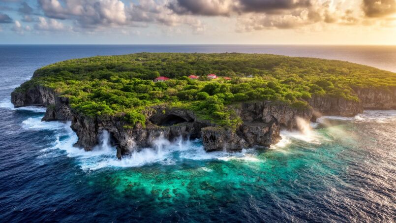
Lost in the heart of the South Pacific, Niue’s Geography is often described as a simple “rock” perched on the ocean. Behind this nickname of the “Rock of Polynesia” lies a surprisingly complex geography, shaped by millions of years of volcanism, coral growth, sea-level variations, and tectonic uplift. Isolated, compact, ringed by limestone cliffs and surrounded by a gigantic exclusive economic zone, the island offers an open-air laboratory on how a raised atoll functions, becomes fragile, and tries to reinvent itself in the era of climate change.
A Landmark in the Tonga–Samoa–Cook Triangle
Niue’s Geography is located in the South Pacific, in Polynesia, at the heart of a triangle formed by Tonga, Samoa, and the Cook Islands. Its geographical coordinates are around 19°02’–19°03′ South and 169°51’–169°52′ West, a position well west of the International Date Line, but close enough that the island is sometimes described as “ten degrees east” of that imaginary line.
The island of Niue is located approximately 2,400 km northeast of New Zealand, 600 km northeast of Tonga, 660 km southeast of Samoa, south of American Samoa, and west of the Cook Islands. This considerable distance from any major archipelago makes it a uniquely isolated territory. Unlike an archipelago, Niue is a single island, forming an autonomous block in the middle of the ocean.
The time zone, UTC-11, underscores this geographical marginality: the island lives almost “out of sync” with major capitals, being, for example, six hours behind Washington, DC during standard time.
A Large Coral Island… of Small Size
On a map, the island appears as an oval lens, about 18 kilometers in diameter and with a circumference of roughly 65 kilometers. The land area varies slightly depending on the source, between 259 and 261.46 km², but all agree on one point: it is one of the largest raised coral islands in the world, while remaining one of the smallest self-governing states on the planet.
The island’s coastline measures 64 kilometers in length.
This volcanic base submerged under coral rock gives the island its status as a “raised coral atoll”: an ancient atoll elevated above sea level by tectonic movements and glacio-eustatic variations during the Quaternary period.
Two Levels of Relief, Cliffs, and a Plateau
The topography of Niue’s geography is remarkably simple in its broad outlines, and extremely detailed in its specifics. The island is structured into two major levels.
The first level, the lowest, corresponds to a coastal terrace about half a kilometer wide, at 25–27 meters above sea level. This terrace slopes down to the shore, forming small cliffs. It is itself indented by coves, inlets, and surge notches, all marks of former higher sea levels and the combined action of swell and cyclones.
Above, a second level forms a central limestone plateau, reaching an average height of about 60 meters. The highest point, an unnamed elevation, is identified either near the locality of Mutalau, at 68–70 meters, or 1.4 kilometers east of Hikutavake, where some surveys mention 80 meters. In any case, the relief remains modest: the island is generally low, its average altitude reaching only about twenty meters.
This two-story architecture translates in the landscape into a succession of structures:
The island of Niue, in the South Pacific, presents a geological structure characteristic of raised atolls, composed of three main elements. An inner basin, called Mutalau Lagoon, corresponds to the former lagoon of the atoll. It is surrounded by a raised reef rim, the Mutalau Reef. Finally, a wide fossil marine terrace, the Alofi Terrace, lies between twenty and thirty meters above sea level, testifying to the island’s past elevation.
Beyond this terrace, the outer margin ends abruptly with a step cut by waves (wave-cut notch), followed by a coral flat, a very narrow fringing reef, and a steep slope plunging into abyssal depths. Less than 5 kilometers from the coast, the ocean floor already exceeds 1,000 meters: Niue’s geography is literally perched on a submarine pedestal that drops off steeply.
A Coastline of Cliffs, Caves, and Rare Beaches
The coastline is dominated by steep limestone cliffs, inherited from the Pleistocene. Continuous sandy beaches are rare; swimming areas are limited to enclosed coves, small inlets nestled at the foot of the cliffs, or coral depressions filled with turquoise water. The most spectacular formations are the sea arches and caves.
In the north of the island, the Talava Arches form a set of three monumental sea arches, accessible via a forest trail. Further west, the Avaiki Cave reveals a vast coastal cave with natural pools, limestone columns, and concretions, illustrating the erosion of limestone by the sea.
Many other caves dot the coastline: Ana, Togo, Vaikona, or the Limu Pools, natural basins formed in the reef where seawater seeps in and rises. These cavities result from the dissolution of limestone by underground freshwater, followed by hollowing out by the sea as sea level rose and fell over glacial cycles.
On the western side, two large bays interrupt the continuity of the cliffs: Alofi Bay, in the center, and Avatele Bay, further south. Between them, the promontory of Halagigie Point marks the westernmost point of the island. In the far southwest, a small rocky cape named Te Pā Point, or Blowhole Point, shoots up sprays of water under the pressure of swell surging into the crevices.
The extreme points of Niue’s geography are carefully identified: an unnamed cape northwest of Uluvehi for the northernmost point, another unnamed cape southeast of Liku for the eastern extremity, Limufuafua Point for the south, and Halagigie Point for the west.
A Continuous but Heavily Indented Fringing Reef
Around the island, a narrow coral reef encircles almost the entire coastline. Unlike large atolls surrounded by inner lagoons, here the reef is plastered against the foot of the cliffs, forming a coral flat that is partially exposed at low tide. The only notable interruption in this coral ring is on the western side, facing Alofi: a break in the reef allows relative access to the sea and determined the historical location of the capital and its anchorage.
The morphology of the reef flat varies with exposure. On the south and east, more exposed to the prevailing winds and ocean swell, the reef is narrower, steeper, and frequently scoured by storms. On the north and west, more leeward, the coral flat is slightly wider, which explains why most villages have clustered on this better-protected coast, especially around Alofi and in the northwest quadrant.
A Single Island, But at the Center of a Vast Maritime Space
If the land area of Niue’s Geography is modest, its maritime zone is, on the other hand, considerable. The state claims a territorial sea of 12 nautical miles and an exclusive economic zone (EEZ) of 200 nautical miles. The area of this EEZ is on the order of 390,000 km² according to the most consistent data, a value sometimes expressed differently but confirming a maritime footprint out of all proportion to the size of the island.
This EEZ extends approximately between 164°W and 172°30’W and between 16°30’S and 23°30’S. It touches the waters of Fiji to the west, those of American Samoa to the north, those of the Cook Islands to the east, while the southern boundary borders international waters. The absence of immediate neighbors within several hundred kilometers underscores the oceanic and isolated character of this territory.
Within this space, Niue’s Geography does not include any other emerged lands, but a few coral reefs and seamounts play an important ecological and fisheries role.
Three Offshore Reefs, Including a Spectacular Submerged Atoll
Three coral reefs without emerged land are located within the EEZ: Beveridge Reef, Antiope Reef, and Haran (or Harans) Reef. They materialize high points of the buried volcanic and coral edifice.
That is the area in square kilometers of the submerged Beveridge Reef atoll.
Beveridge Reef is considered a “young” reef, formed after the last major glaciation, when sea level rose by about a hundred meters some 10,000 to 14,000 years ago. Unlike Niue’s geography, which was uplifted above the sea, Beveridge remains an active atoll, where coral still grows at the surface.
Several coral formations are located in Niuean waters. Antiope Reef, 180 km to the northeast, is a circular platform about 400 m in diameter with a minimum depth of 9.5 m. Haran Reef, 294 km to the southeast, is a similar coral shoal but less documented. Further southwest, Albert Meyer Reef is a plateau about 5 km across with a minimum depth of 3 m, not officially claimed by Niue. Finally, the Haymet Rocks, located more than 1200 km to the east-southeast, have their existence questioned.
These structures complete a submarine landscape dotted with at least fourteen seamounts, mapped notably using data from satellite altimetry (SEASAT, GEOSAT, ERS-1, TOPEX/POSEIDON). The precision of these surveys allows depth estimates with a margin of error of less than 10% of the average depth, for a horizontal resolution of about 5 km.
A Geological History Written by Glaciations
Understanding the geography of Niue requires going back in time well before human presence. The island was born from submarine volcanism, followed by coral construction that gradually “clothed” the volcano in reef and lagoon limestones.
Fossils found in the ancient lagoon (Mutalau Lagoon) attest to deposits dating from the Plio-Pleistocene, that is, before the major glaciations of the last 1.6 million years. The absence of Tertiary fossils (56–2 million years) suggests that most of the limestone cover is relatively recent on a geological scale.
During glacial and interglacial cycles, sea level rose and fell by several tens, even hundreds of meters. For example, during the last glaciation, sea level was 70 to 110 meters lower than today. Conversely, some older interglacial episodes, a few hundred thousand years ago, were associated with sea levels even higher than the current one, sometimes estimated at over 100 meters above.
Sea-level variations have shaped Niue’s geography, creating marine terraces, flats at different levels, and fossil reef crests. The Alofi Terrace, an almost continuous belt around the island, is an ancient reef platform formed during interglacials like the Milazzian and Tyrrhenian phases, 170,000 to 120,000 years ago, then reworked during more recent episodes. Other phases of reef growth and erosion are linked to older glaciations (Mindel, Riss, Würm).
The whole forms a stack of terraces and steps, visible in cross-section from the central basin (Mutalau Lagoon, 30–40 m elevation), passing through the reef rim (Mutalau Reef, 45–75 m), the Alofi Terrace (20–27 m), then the current fringing reef.
Unique Soils, Between Natural Radioactivity and Limited Fertility
This geological history and tropical conditions have given rise to particular soils. Part of Niue’s land is covered by extremely leached tropical soils, classified as oxisols, with unusual geochemical characteristics: high levels of iron and aluminum oxides, notable presence of mercury, and natural radioactivity linked to the decay of elements such as thorium-230 and protactinium-231.
The observed signatures are explained by a multi-stage geological scenario: intense weathering of surface corals, followed by a brief marine submersion about 120,000 years ago, then by the upwelling of deep marine fluids. These fluids, rich in metals and radioactive isotopes, circulate through permeable chimneys in the limestone via an endothermal upwelling phenomenon, linked to residual thermal activity of the volcanic basement.
Analyses conclude, however, that this radioactivity remains low and that no deleterious effects on human health have been demonstrated. On the other hand, these soils are paradoxical for agriculture: very rich in phosphorus, but in the form of insoluble iron phosphate (crandallite), thus poorly accessible to plants. Deficiencies in potassium and often nitrogen are observed, along with alkaline pH, limited water retention capacity, and in places, a very high proportion of rock outcrops (10 to 60% of the surface).
It is estimated that about 30 to 40% of the island’s surface is, in fact, poorly suited for agriculture, due to a lack of deep soil or appropriate structure. The most fertile lands are concentrated in the north, while the south, more heavily cultivated and cleared over time, shows areas of “fernlands,” landscapes of ferns and degraded fallows sometimes described as a “desert.”
A Humid Tropical Climate Driven by Trade Winds and Cyclones
On this mineral foundation, the climate plays a determining role. Niue’s geography is subject to a tropical rainforest climate, classified as Af in the Köppen system. Temperatures remain high year-round, with low seasonal amplitude. Data from the Alofi station show average maximums around 27 °C, average minimums near 22 °C, and a daily average temperature of about 25 °C. Extremes have been recorded, however, with peaks up to 38 °C and exceptional lows around 9 °C.
The year is marked by two main climatic seasons. From November to April, it is the hot and humid season, corresponding to the austral summer, with heavier temperatures, very high humidity, and abundant rainfall. From May to October, the atmosphere is slightly cooler, relatively drier, and sunnier: this is the so-called “dry” season, although it still rains regularly.
Average data and monthly variations in precipitation
The average annual rainfall is about 2,018 mm.
The data show significant monthly variations.
The core wet season months are particularly rainy.
| Month | Average Rainfall (mm) |
|---|---|
| January | 261.6 |
| February | 253.6 |
| March | 305.6 |
| April | 202.6 |
| May | 138.2 |
| June | 88.9 |
| July | 96.4 |
| August | 105.8 |
| September | 102.4 |
| October | 123.8 |
| November | 145.5 |
| December | 196.2 |
The period November–April thus concentrates the most intense rains, often in the form of violent downpours or episodes of several days of bad weather. From May to October, monthly totals are more around 90 to 140 mm, with a relative minimum in June-July.
The prevailing winds are the southeast trade winds, which blow more strongly during the dry season and moderate the heat. They also bring heavy swell to the exposed southern and eastern coasts.
On the Edge of the Tropical Cyclone Belt
Niue’s geography lies on the southern edge of the Pacific cyclone belt. The cyclone season generally runs from November to May, with a peak risk between late December and early April. On average, a notable tropical storm or cyclone hits the island every few years.
Extreme weather events, such as strong winds and high swell, concretely modify the coastal landscape. They can tear away corals, reshape beaches, notch cliffs, enlarge caves, and deposit large boulders. The southeast coast, more exposed, generally shows more traces of these phenomena than the more sheltered northwest coast.
Underwater, some areas called “barren zones” testify to these repeated blasts: virtually bare rock surfaces, colonized mainly by encrusting algae, where corals and benthic vegetation struggle to re-establish durably. Elsewhere, reefs recover quickly after each event, but remain very sensitive to the increased frequency and intensity of cyclones linked to global warming.
The sea surface temperature remains, for its part, always favorable for swimming, oscillating between 25 and 28 °C depending on the season, with a minimum around 25.5 °C in the austral winter (July–September). The average sunshine, 11 to 13 hours of daylight, and UV indices often at their maximum, highlight the power of equatorial radiation on this isolated island.
Freshwater and the Coral Karst: A Fragile Resource
The absence of visible rivers or lakes does not mean an absence of freshwater. Below the surface, rainwater that infiltrates the limestone forms a freshwater lens floating on denser seawater. Artesian wells and coastal springs provide access to this reserve, whose level is a few meters above sea level near the coast, and deeper (around 50–60 meters below the plateau surface) inland.
This karstic lens is vulnerable to contamination due to its porous substrate, which facilitates the infiltration of surface pollutants (domestic effluents, animals, agricultural products). The absence of watercourses prevents any natural dilution of pollutants. The authorities consider this issue major, especially as climate change, by intensifying droughts, could reduce aquifer recharge.
Official hydrological statistics even paradoxically mention “total renewable water resources” estimated at 0 m³, which above all reflects extreme caution in estimates of the mobilizable reserve on a large scale, and dependence on rain and individual storage (tanks, rooftops).
Forests, Agricultural Lands, and Land Use
Despite its rocky appearance, Niue’s geography is heavily forested. The most recent estimates indicate that over 70% of the island’s surface is covered by forests, in various forms: littoral forests, coastal forests, mature dense forests (Huvalu), regenerating secondary forests, and mosaics of scrub and crops.
In 2018, the distribution of land use was summarized as follows:
| Land Use Category | Share of Land Area |
|---|---|
| Agricultural land (total) | 19.1% |
| – of which arable land | 3.8% |
| – of which permanent crops | 11.5% |
| – of which permanent pasture | 3.8% |
| Forests | 71.2% |
| Other uses (built-up, roads, bare land, etc.) | 9.7% |
Older data gave a different picture (19% arable land, 8% permanent crops, 4% pasture, 19% forest, 50% other), a sign that classification methods and category definitions have evolved. In any case, agriculture covers only a limited part of the territory, but it plays a central role in daily life.
The majority of families practice subsistence agriculture, cultivating taro, cassava, yam, bananas, tropical fruit trees, and coconuts, often on the edge of the plateau or on the coast. Land is held according to a customary system by large family groups (magafaoa), passed down between generations, and cannot be sold to foreigners.
Between Shifting Cultivation and Soil Conservation
One traditional practice has long been shifting slash-and-burn cultivation, with significant fallow periods. This system, well adapted to low population densities, has however led in some areas, particularly in the south, to soil degradation, expansion of fernlands, and reduced fertility.
Sustainable annual volume of timber that the forests can provide if managed prudently.
At the same time, a very strong orientation toward organic agriculture has emerged. The Niue Island Organic Farmers Association promotes the conversion of farms and works towards international agreements for Niue’s geography to be recognized as a fully organic nation. Crops like vanilla and noni (Morinda citrifolia) are highlighted in this strategy, despite setbacks suffered during certain cyclones.
Marine Resources and Protected Areas on an Oceanic Scale
The sea surrounding Niue’s geography is an integral part of its geography. From a benthic perspective, the reefs exhibit a typical composition of isolated oceanic islands. Surveys show, at some stations, a coverage of 28% crustose coralline algae, 19% live hard coral, 17% Lobophora algae, 13% bare substrate, and 12% erect algae. Hard corals are more abundant on leeward slopes (26% coverage) than on exposed sectors (8%), while encrusting algae dominate the swell-beaten areas more.
The diversity and biomass of reef fish are limited, notably due to the narrowness of the fringing reef and the absence of a large lagoon. Some counts have recorded a total absence of sharks. These resources are therefore both precious and fragile for local communities.
Conscious of this importance, the leaders of Niue’s geography made a radical decision in 2022: to classify the entire EEZ as a marine park, the Niue Nukutuluea Multiple-Use Marine Park. This vast scheme encompasses a highly protected marine area (Niue Moana Mahu, where commercial fishing is heavily regulated or even prohibited over large areas), as well as a special management zone around Beveridge Reef, the Beveridge Reef Nukutulueatama Special Management Area.
That is the percentage of Exclusive Economic Zone waters placed under strict protection.
One of the major challenges of this conservation ambition lies, however, in surveillance. Niue’s geography has only limited human resources (a handful of fisheries officers) and does not have patrol boats permanently based on the island. Enforcing the rules in this immense EEZ therefore depends on collaborations, particularly with the New Zealand Defence Force.
A Human Geography Intimately Linked to the Relief
On this raised atoll, the population is mainly distributed along the more accessible western fringe. The capital, Alofi, occupies the center of the west coast, overlooking the eponymous bay where the reef break allows a relative anchorage. The majority of the 14 villages are located on or near the first terrace, a few tens of meters above sea level, immediately bordering the sea.
The most populous villages of Niue are located in the western sector of the island. Alofi South and Alofi North together concentrate more than a third of the total population. Other important population centers are the villages of Hakupu and Tamakautoga. In contrast, the eastern part of the island, more exposed to swell and trade winds, has a much lower and sparser population density.
The road network follows this geography: a circular road follows approximately the periphery of the island on the coastal terrace, while a few transverse roads cross the plateau to connect the eastern villages to Alofi. Plantations are more extensive inland, on deeper soils, although the thin soil layer and limestone blocks sometimes make mechanization difficult.
Most inhabitants live as close as possible to the sea, but never at sea level. The cliffs provide relative protection against waves and sea-level rise, even if cyclones can cause considerable damage to coastal infrastructure, as was the case in Alofi during destructive events.
A “Rock” Turned Green
Beyond the physical description, the geography of Niue is inseparable from the political choices that aim to adapt this mineral and oceanic territory to the Anthropocene. The island has adopted a “green growth” strategy, banking on a combination of conservation, organic agriculture, renewable energies, and the valorization of its isolation (for example, through the labeling of the entire island as a dark sky sanctuary, enabling astrotourism activities).
That is the power in kilowatts of the first photovoltaic panel array connected to the national grid in 2009.
The stated goal is to reach 80% renewable energy in the electricity mix, a target initially set for 2025 then shifted to early 2026. This proactiveness coexists with a paradoxical observation: due to the very small population, per capita greenhouse gas emissions were among the highest in the world in 2012, each liter of fuel consumed weighing more when reported to such a small number of residents.
In 2023, joined other Pacific island states to launch the Port Vila call for a just transition to a fossil-fuel-free Pacific, marking the will to translate its vulnerable geography into political advocacy on the international stage.
Niue’s Geography
An Island Model of Insular Vulnerability
Many elements of Niue’s geography converge on the same reality: that of a territory particularly exposed to external shocks. Extreme isolation, the absence of a protective lagoon, the small size of exploitable soils, dependence on a vulnerable freshwater lens, proximity to the cyclone belt, and the fact of literally sitting on an ancient now-inactive volcano destined for distant subduction, compose a picture where resilience must be built in the details.
The island’s relief, with its cliffs and plateau, partially protects it from sea-level rise compared to low-lying atolls. However, this same geographical configuration makes access to the sea difficult, concentrates human activities on a few vulnerable bays, amplifies the impact of storms on limited and fragile infrastructure, and traps freshwater resources in a poorly permeable limestone basement.
Faced with this geography, the committed responses – a marine park covering the entire EEZ, a protected night sky policy, solar development, promotion of organic agriculture, and cautious land reforms – paint the portrait of a micro-nation trying to transform its physical constraints into symbolic and economic assets.
Niue is an ancient volcano covered in coral, topped with forests and gardens, and surrounded by a vast ocean. This unique geography places the island at the heart of debates on ocean protection, climate change adaptation, and development models for small island states.
Disclaimer: The information provided on this website is for informational purposes only and does not constitute financial, legal, or professional advice. We encourage you to consult qualified experts before making any investment, real estate, or expatriation decisions. Although we strive to maintain up-to-date and accurate information, we do not guarantee the completeness, accuracy, or timeliness of the proposed content. As investment and expatriation involve risks, we disclaim any liability for potential losses or damages arising from the use of this site. Your use of this site confirms your acceptance of these terms and your understanding of the associated risks.

Cyril Jarnias is an independent expert in international wealth management with over 20 years of experience. As an expatriate himself, he is dedicated to helping individuals and business leaders build, protect, and pass on their wealth with complete peace of mind.
On his website, cyriljarnias.com, he shares his expertise on international real estate, offshore company formation, and expatriation.
Thanks to his expertise, he offers sound advice to optimize his clients' wealth management. Cyril Jarnias is also recognized for his appearances in many prestigious media outlets such as BFM Business, les Français de l’étranger, Le Figaro, Les Echos, and Mieux vivre votre argent, where he shares his knowledge and know-how in wealth management.





