
 Published on and written by Cyril Jarnias
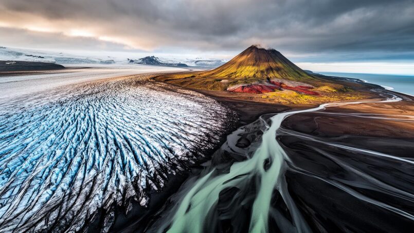
Wedged between Greenland and Scandinavia, situated at the junction of the Arctic Ocean and the North Atlantic, Iceland is a textbook case in geography. Two tectonic plates spreading apart, a mantle plume feeding volcanoes, giant ice caps, deep fjords, and lava deserts: everything on this 103,000 km² territory tells the story of a brutal clash between fire and ice.
Iceland is the 18th largest island in the world and the second largest in Europe. It is one of the least densely populated countries, with about 3 inhabitants per square kilometer. Its climate is harsh yet surprisingly mild for its latitude, and its explosive terrain contributes to landscapes that are nearly unique.
An Island Straddling Two Worlds
Iceland occupies a unique geographical position. It lies at the meeting point of the North Atlantic Ocean and the Arctic Ocean, between latitudes 63° and 68° North—roughly at the same latitude as Alaska or southern Greenland. Yet most of the main island remains south of the Arctic Circle, which only the island of Grímsey crosses.
Width in kilometers of the Denmark Strait separating the country from Greenland.
Key Location Figures
| Indicator | Approximate Value |
|---|---|
| Total area | ~103,000 km² |
| Area of main island | ~101,800 km² |
| Latitude | 63° N – 68° N |
| Longitude | 25° W – 13° W |
| Distance to Greenland | ~280–320 km |
| Distance to United Kingdom | ~800 km |
| Coastline length | ~4,970 km (≈ 3,100 miles) |
| EEZ (Exclusive Economic Zone) | ~751,000 km², up to 200 nautical miles |
Politically and culturally, Iceland is grouped with Europe and the Nordic countries. Geologically, however, it shares its identity between the North American and Eurasian plates, which it literally straddles.
A Plateau Relief Cut by Faults
Contrary to the image of a purely mountainous country, Iceland’s relief is first and foremost a vast basaltic plateau, notched and uplifted. About three-quarters of the island lies above 200 meters in elevation, and the heart of the territory is occupied by a high volcanic plateau that averages around 500 meters. From this basaltic table emerge more pronounced landforms: volcanoes, ice caps, mountain ridges, and structural depressions.
Iceland’s highest point, Hvannadalshnúkur, reaches this maximum altitude in meters.
The topography results from the accumulation of successive lava flows, forming plateaus inclined toward the interior of the country. Between these high basalt layers, U-shaped valleys, carved by glaciations, and down-faulted areas occupied by volcanoes or lakes complete an extremely young landscape on a geological scale: the oldest exposed rock is only about 16 million years old.
Simplified Breakdown of Major Surface Types
Compiled data for Iceland shows a very clear split between barren surfaces, ice, lava, and rare productive areas.
| Cover Type | Order of Magnitude (km²) | Share of Territory |
|---|---|---|
| Glaciers | ~11,000–12,000 | ≈ 10–11% |
| Lava fields | ~11,000 | ≈ 11% |
| Sands / volcanic deserts | ~4,000 | ≈ 4% |
| Inland waters | ~3,000 | ≈ 3% |
| Pastures | ~1,000 | ≈ 1% (grazing core) |
| Tundra & bare surfaces | ~60,000+ | ≈ 60% |
| Cultivated land | ~1% of surface | Very minor |
It is estimated that about 80% of the island is uninhabitable: cold highlands, deserts of scoria and ash, glaciers, and quicksand areas. The majority of settlements are therefore concentrated along thin coastal strips and a few milder valleys.
A Coastal Country: Fjords, Capes, and Archipelagos
With nearly 5,000 kilometers of coastline for 103,000 km², Iceland is resolutely a maritime country. Its outline is far from regular: capes, peninsulas, and fjords follow one another, especially in the west, north, and east. Only the southern coast, dominated by vast glacial sandurs, presents more rectilinear lines punctuated by lagoons.
To the north, the coasts face the Greenland Sea; to the east, they plunge into the Norwegian Sea; to the south and west, they directly overlook the North Atlantic, while the northwest opens onto the Denmark Strait. This configuration offers countless natural shelters for fishing, particularly in the fjords.
Iceland has over a hundred fjords, formed by glacial erosion and subsequent sea incursion. In the west, the Westfjords peninsula is a dense network of fjords and valleys separated by steep mountains. To the east, a series of deeply incised fjords stretches for about 120 km of coastline, connecting the highlands to the ocean.
Iceland is not just its large main island. There are about thirty to forty secondary islands: the Vestmannaeyjar archipelago in the south, known for its puffin colonies; Grímsey, the only Icelandic fragment straddling the Arctic Circle; Flatey in Breiðafjörður Bay; and Surtsey, a volcanic island born from a submarine eruption in the 1960s.
Eight Major Regions, a Desert Heart
To describe its geography, Iceland is often divided into eight major regions, reflecting both physical realities and settlement areas.
The Capital Region around Reykjavík alone concentrates over 60% of the national population in just over 1,000 km². Wedged between Faxaflói Bay and the first inland reliefs, it extends southwest onto the Reykjanes Peninsula, an area of black lava and geothermal fields where the international airport is located.
North of the capital, the Western region presents varied landscapes including agricultural valleys, fjords such as Hvalfjörður with the high Glymur waterfall, and volcanic massifs. Farther north, the Westfjords peninsula, covering over 9,000 km², is very sparsely populated due to its rugged terrain.
The Northwest and Northeast regions open onto wide fjords like Skagafjörður or Eyjafjörður, the latter harboring Akureyri, the main town of the north. To the east, the Austurland region lines deep fjords, forested valleys (Hallormsstaður, one of the country’s largest wooded areas), and wind-exposed plateaus.
The South is the great agricultural plain, backed by the volcanic and glacial chain stretching from Hekla to Katla via Eyjafjallajökull. Most of the cultivated land, vast grazing pastures, and the famous black sand beaches are found here.
Geographical description of South Iceland
In the center, the Highlands—approximately 40,000 km²—form a sort of lunar “interior,” dominated by stacked lava flows, ash fields, volcanic mountains, and ice caps. No permanent settlement exists there, and paved roads are virtually absent, replaced in summer by 4×4 tracks.
The Heart of the System: Hotspot and Mid-Atlantic Ridge
What makes Iceland’s geography so spectacular happens beneath the surface: the island sits exactly atop the Mid-Atlantic Ridge, the divergent boundary between the North American and Eurasian plates, and over a powerful mantle plume, the Icelandic plume. The result is an exceptional level of volcanic and seismic activity for such a small area.
The Ridge, which runs the length of the Atlantic from north to south, surfaces above sea level in Iceland, the only large landmass emerging on such an oceanic rift. The two plates spread apart by about 1.8 to 2 centimeters per year, contributing to enlarging the country by roughly five centimeters per year when considering the entire fault system.
At Þingvellir in southern Iceland, the national park lies in a rift valley where parallel faults cut through the Earth’s crust. The cliffs of Almannagjá and Hrafnagjá mark the boundary of the Hreppar microplate, which is wedged between the North American plate and the active edge of the Eurasian plate. This site makes the process of plate divergence tangible.
The mantle plume, meanwhile, brings an additional supply of hot magma, explaining why the ridge is elevated and volcanism is so intense. Of some 200 potential volcanoes, about 30 systems are considered active, of which about 15 have had historical eruptions since the 9th century. It is estimated that roughly one-third of the lava emitted on Earth’s surface since 1500 has come from this small island.
Volcanoes, Faults, and Earthquakes: An Open-Air Landscape Factory
Iceland is divided into several volcanic zones and major seismic zones. Three rift zones dominate: the Western Volcanic Zone (WVZ), the Eastern Volcanic Zone (EVZ)—currently more active—and the Northern Volcanic Zone (NVZ). They are connected or offset by transform fault zones, such as the South Iceland Seismic Zone (SISZ) in the south and the Tjörnes Fracture Zone in the north.
The number of years of relative calm the Reykjanes Peninsula experienced before its new eruptive cycle began in 2021.
Under the Vatnajökull ice cap, the eastern zone concentrates some of the island’s most productive systems, notably Grímsvötn, Bárðarbunga, and Kverkfjöll. The Holuhraun fissure eruption of 2014–2015 produced more than 85 km² of lava flows and about 1.4 km³ of magma, the largest eruption of this type since 1783. Already in the 18th century, the Laki flow—linked to the Grímsvötn system—had poured about 14.7 km³ of basalt over southern Iceland.
Iceland’s fracture zones, such as the SISZ and TFZ, are the sites of powerful earthquakes, with magnitudes regularly reaching near 7. Recent history includes the twin magnitude 6.3 earthquakes in the south in 2008, the large Skagafjörður earthquakes in 1963, and the repeated seismic and volcanic crises on the Reykjanes Peninsula since 2020, which led to the evacuation of the town of Grindavík due to eruption risk.
This hyperactive tectonism not only shapes the relief but also feeds a vast geothermal system, giving rise to countless hot springs, fumaroles, solfataras, and geysers, including the famous Geysir, which gave its name to the phenomenon.
Glaciers: The Weight of Ice in the Shadow of Volcanoes
About one-tenth of Iceland’s surface is currently covered by ice. There are more than 260 named glaciers, ranging from small cirque glaciers nestled in mountain hollows to immense ice caps blanketing entire mountain ranges. The distribution is uneven: most ice is concentrated in the center and south of the island, where snowfall is heaviest.
Vatnajökull, Iceland’s largest glacier, covers about 8% of the country with an area of 7,800 to 8,300 km² and a thickness that can exceed 1,000 meters. It generates about thirty glacial tongues. Beneath the ice lie active volcanoes like Grímsvötn and Bárðarbunga, whose activity can trigger jökulhlaups—violent floods resulting from subglacial volcanic melting.
Behind this giant come Langjökull, a long glacier in the west with nearly 800–900 km² of ice, then Hofsjökull in the center (about 800–900 km²) and Mýrdalsjökull in the south (around 500–600 km²), perched above the Katla caldera. Farther northwest, Drangajökull occupies a unique place: it is the only glacier in the Westfjords, the most northerly in the country, and one of the few not in strong retreat.
Major Ice Caps
| Main Glacier | Approximate Area | Primary Location |
|---|---|---|
| Vatnajökull | ~7,800–8,300 km² | Southeast / Highlands |
| Langjökull | ~800–900 km² | West / Interior |
| Hofsjökull | ~800–900 km² | Central Highlands |
| Mýrdalsjökull | ~500–600 km² | South, above Katla |
| Drangajökull | ~140–160 km² | Westfjords (Northwest) |
Alongside these giants, a multitude of smaller glaciers play a major role in the landscape: Eyjafjallajökull, a mountain ice cap that made headlines in 2010; Snæfellsjökull, an iconic glacial cone at the tip of the Snæfellsnes Peninsula; Tungnafellsjökull, Eiríksjökull, Tindfjallajökull, and Torfajökull.
Iceland’s glaciers are mostly “temperate,” with ice near 0°C throughout most of their thickness, which accelerates their flow. They feed most of the country’s major rivers and many waterfalls. Their stored water reserve is equivalent to nearly twenty times the island’s annual precipitation.
But this cryosphere is changing rapidly. Since the early 2000s, Iceland’s glaciers have already lost 7 to 10% of their volume. Vatnajökull is thought to have lost more than 15% of its mass in a century, and smaller glaciers, like Okjökull in the west, have disappeared entirely. The melting is manifested by the formation of spectacular glacial lagoons, such as Jökulsárlón at the foot of Breiðamerkurjökull, now the country’s deepest lake, or by a measurable uplift of the crust (up to 20–30 mm per year in some areas), responding to the unloading of ice.
Rivers, Waterfalls, and Lagoons: An Explosive Hydrological Network
In a country so wet—the southern coast receives up to 3,000 to 4,000 mm of annual precipitation in places—and so young geologically, watercourses are everywhere. More than 50 major rivers structure the drainage of the plateau, often short, powerful, and difficult to navigate.
Many Icelandic rivers are fed by glacial meltwater, giving them a milky or yellowish color due to sediments. The Þjórsá River, the longest in the country (230 km), originates under the Hofsjökull glacier. The Jökulsá á Fjöllum River, issuing from Vatnajökull, flows more than 200 km north, carving the Jökulsárgljúfur canyon and feeding the powerful Dettifoss waterfall.
Purely glacial rivers alternate with mixed or spring-fed rivers, such as Laxá, the “salmon river” that drains from Lake Mývatn, or Sog, which drains Lake Þingvallavatn and converges with the Hvítá to form the Ölfusá, a river with an average flow exceeding 400 m³/s, a national record.
Lava flows, moraine dams, or ice trap water to create a series of lakes. These range from small crater ponds to large bodies like the artificial reservoir of Þórisvatn (about 80 km²) or the natural lake of Þingvallavatn. Glacial lagoons, such as Jökulsárlón, are the most spectacular: they receive icebergs from the Breiðamerkurjökull glacier, which then drift toward the ocean to wash up on the “Diamond Beach.”
Abrupt breaks in slope and the youthfulness of the relief give rise to hundreds of waterfalls, sometimes concentrated in a single catchment: Gullfoss on the Hvítá, Goðafoss and Aldeyjarfoss on the Skjálfandafljót, Skógafoss and Seljalandsfoss near the south coast, Dynjandi in the Westfjords, Hengifoss with its red and black strata on the edge of Lake Lagarfljót.
A Cold, Oceanic Climate… and Surprisingly Mild
Judging by the map, Iceland would seem destined for a polar climate. In reality, it benefits from a major thermal anomaly: the Gulf Stream and its North Atlantic extensions, which bring relatively warm waters from the Caribbean to the country’s shores.
Iceland has a subpolar oceanic climate (Cfc according to Köppen) on its coasts, which becomes a tundra climate (ET) on the Highlands. Mean annual temperatures range from 0 to 4°C in the lowlands and drop below freezing inland. In Reykjavík, the annual average is about 5°C, with January averages of –0.5°C and July averages of 11–12°C. These temperatures are more similar to those of Edinburgh or Hamburg than to a typical Arctic archipelago.
The downside of this relative mildness is notoriously unstable weather. Fronts from the Atlantic collide with cold air masses from the Arctic, generating explosive depressions, especially in autumn and winter. The average wind speed is high (around 19 km/h over the year) and gusts can exceed 60–70 m/s on peaks or in exposed valleys, i.e., over 200 km/h. Icelanders sum it up with a proverb: “If you don’t like the weather, wait five minutes.”
Some glacial areas in the south receive more than 5,000 mm of annual precipitation.
Light also changes drastically over the course of the year. Around the summer solstice, the north of the island experiences nearly 24 hours of daylight, with a pronounced “midnight sun” near the Arctic Circle. In December, conversely, Reykjavík gets only 4 to 5 hours of daylight, making the polar night an ideal playground for the Northern Lights.
Fragile Soils, Sparse Vegetation
When the first Norse settlers arrived in the 9th century, the best estimates suggest that 25 to 40% of the island was covered by forests, primarily downy birch. Overall, nearly 60% of the territory supported continuous vegetation—forests, heathlands, bogs, wet meadows. A thousand years later, the picture has changed radically.
Forest now covers only about 1% of the country’s surface, a thousandth of the forest cover of neighboring countries like Norway.
Young volcanic soils, rich in ash and pumice, are extremely susceptible to wind and water erosion once stripped of their plant cover. Today, it is estimated that three-quarters of Iceland is affected by soil erosion, and about one-third of the territory has become desert or semi-desert. Nearly 45% of terrestrial ecosystems are deemed to be in “poor condition.” It is one of the least vegetated countries in Europe, if not the least covered.
Since the early 20th century, reforestation efforts have been carried out under the auspices of the Soil Conservation Service and forestry services. They combine replanting native species (such as birch) with the introduction of exotic conifers (Sitka spruce, lodgepole pine, larch) to quickly stabilize soils. Fixing plants, such as Nootka lupine, have also been introduced, with agronomic success but raising ecological debates.
A few woodlands remain or are regenerating: Hallormsstaðaskógur in the east, Vaglaskógur in the north, Kjarnaskógur near Akureyri, and the forests of the Þórsmörk region in the south. These contain not only native trees (birch, rowan, willows) but also a mosaic of imported species. Overall, however, the vegetation mosaic remains dominated by heathlands, mosses, lichens, and grasslands.
Overview of Vegetation Cover and Land Use
| Category | Estimation / Approximate Share |
|---|---|
| Continuous vegetation (all types) | ~25–30% of territory |
| Sparse or very sparsely vegetated surfaces | ~60,000 km² (≈ two-thirds of the country) |
| Forests (mainly birch) | ≈ 0.5–1% |
| Agricultural land (broad sense) | ≈ 18–24% (including pastures) |
| Cultivated land (arable, crops) | ≈ 1% |
| Wetlands (bogs, marshes) | ~10,000 km² (part of continuous zones) |
Natural Resources: Fish, Water, and the Earth’s Heat
While Iceland lacks trees, it does not lack natural resources. The ocean provides a vast fish biomass, which for a long time sustained the country almost single-handedly. Species such as cod, herring, capelin, and blue whiting have supported major fisheries; in the 2000s, blue whiting catches peaked at over 500,000 tons in some years.
Powerful rivers and abundant lakes offer high hydropower potential, extensively exploited. Dams such as Kárahnjúkar, Búrfell, or Sigalda convert the flow of the Þjórsá, Tungnaá, and other rivers into cheap electricity, which notably powers energy-intensive aluminum smelters.
But it is perhaps the geothermal resource that best illustrates the alliance between geography and society. The hot waters that spring from the depths heat nearly 97% of homes, supply greenhouses and swimming pools, and produce a substantial share of electricity. Plants like Hellisheiði or Nesjavellir capture steam or superheated water to convert it into energy.
Altogether, 100% of the electricity generated in the country comes from renewable sources (hydropower and geothermal), placing Iceland at the very top globally in terms of energy transition. A reality intimately linked to its unique geology.
A Geography That Shapes Settlement
The extreme ruggedness of the relief, the massive presence of glaciers, poor soils, and the windy climate have shaped a very particular settlement pattern. About 94% of the population lives in settlements of more than 200 inhabitants, almost all located on the coast or at the heads of fjords. The interior of the island is nearly empty.
About two-thirds of Iceland’s population resides in the Reykjavík region, which includes the capital and neighboring municipalities. Other secondary urban centers exist, notably Akureyri in the Northeast, the Keflavík-Njarðvík conurbation, as well as towns like Selfoss, Akranes, Ísafjörður, Egilsstaðir, and Höfn.
This concentration along the coasts is explained by a combination of geographical factors: the presence of natural harbors in the fjords, slightly more fertile land in coastal valleys, a milder climate thanks to oceanic influence, and relative distance from the most unstable volcanic zones of the interior.
A Territory in Motion Facing Climate Change
Because it is young, unstable, and subject to an increasingly warm climate, Iceland reacts quickly to global changes. The accelerated retreat of glaciers is the most visible symptom, but it triggers a cascade of geographical effects.
As the ice caps thin, the Earth’s crust rebounds: in some areas south of Vatnajökull, the uplift rate exceeds 20 millimeters per year, measured by GPS. This isostatic rebound alters slopes, river regimes, and potentially the stability conditions of certain slopes, increasing the risk of landslides.
The total melting of Iceland’s glaciers would contribute about one centimeter to global sea-level rise.
Changes in sea temperature and ocean circulation also affect marine ecosystems and fish stocks, with direct economic consequences. Aware of this vulnerability, Iceland closely monitors the evolution of systems like the Atlantic Meridional Overturning Circulation (AMOC) and has even classified a potential collapse of this major circulation as a national security risk, due to possible effects on European climate, agriculture, and energy.
A Geography as a Cultural Matrix
Finally, it is impossible to discuss the geography of the country in Iceland without mentioning its cultural dimension. The dramatic relief and relative isolation have shaped a society oriented toward the sea, but also a literature and imagination nourished by natural forces. The medieval sagas already describe eruptions, harsh winters, famines linked to jökulhlaups or ash fall.
Even today, daily life is still punctuated by seismic alerts, avalanche bulletins in the fjords, storm warnings on the highlands, or road closures due to glacial floods. Icelanders have learned to live with a territory that moves—literally—beneath their feet.
Iceland’s extreme geography—with its glaciers, lava fields, fjords, and black deserts—is a major attraction. More than just a backdrop, it is a prime observation ground for geological processes such as continental drift, volcanism, glaciations, erosion, and the effects of climate warming.
In this sense, the geography of the country in Iceland is not just an assembly of maps and figures: it is the deep fabric that connects a people to a piece of the Earth’s crust in full transformation, halfway between Europe and America, between the Atlantic and the Arctic, between fire and ice.
Disclaimer: The information provided on this website is for informational purposes only and does not constitute financial, legal, or professional advice. We encourage you to consult qualified experts before making any investment, real estate, or expatriation decisions. Although we strive to maintain up-to-date and accurate information, we do not guarantee the completeness, accuracy, or timeliness of the proposed content. As investment and expatriation involve risks, we disclaim any liability for potential losses or damages arising from the use of this site. Your use of this site confirms your acceptance of these terms and your understanding of the associated risks.

Cyril Jarnias is an independent expert in international wealth management with over 20 years of experience. As an expatriate himself, he is dedicated to helping individuals and business leaders build, protect, and pass on their wealth with complete peace of mind.
On his website, cyriljarnias.com, he shares his expertise on international real estate, offshore company formation, and expatriation.
Thanks to his expertise, he offers sound advice to optimize his clients' wealth management. Cyril Jarnias is also recognized for his appearances in many prestigious media outlets such as BFM Business, les Français de l’étranger, Le Figaro, Les Echos, and Mieux vivre votre argent, where he shares his knowledge and know-how in wealth management.





