
 Published on and written by Cyril Jarnias
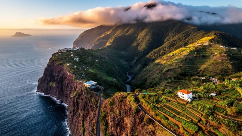
Isolated in the middle of the Atlantic but fully anchored in Europe, the Geography of the country in Madeira is the story of an archipelago tiny on a global scale, but with astonishing geographical complexity. Dormant volcanoes, vertiginous cliffs, wind-swept plateaus, relic forests from another age, uninhabited islands classified as strict nature reserves: everything comes together to make this Portuguese autonomous region a full-scale laboratory of physical and human geography.
A European region… on the African plate
The Geography of the country in Madeira begins with a paradox: politically and culturally, the territory unambiguously belongs to Portugal and the European Union; geologically, the archipelago sits on the African tectonic plate, within the biogeographic region of Macaronesia.
Located in the North Atlantic, the Madeira archipelago occupies a subtropical position, slightly north of the Tropic of Cancer, at latitudes close to Casablanca. Its geographic center lies around 32°45’N, 17°00’W. This location, closer to African coasts than to Europe, gives it an “eternal spring” climate but also contributes to a certain feeling of isolation.
Distances that redraw the mental map
The numbers speak for themselves: the archipelago is located about 900 to 1,000 km from mainland Portugal, compared to only 520 km from the Moroccan coast. The relative proximity of the Canary Islands to the south reinforces this physical belonging to the Atlantic-African block, while maintaining a clear political and cultural separation.
| Geographic reference | Approximate distance to the archipelago |
|---|---|
| Lisbon (capital of Portugal) | 900–1,000 km northeast |
| Sagres (Algarve, closest point) | ~805 km |
| Coast of Morocco (North Africa) | ~520–600 km east |
| Canary Islands (Spain) | ~400–500 km south |
| Azores (another autonomous region) | ~880 km northwest |
Politically, the Geography of the country in Madeira forms with the Azores one of the two Portuguese autonomous regions. It is also classified as an outermost region of the European Union. On about 800 km² of emerged land, the region is organized into 11 municipalities and about fifty civil parishes, with its own regional assembly and a government with expanded powers.
A volcanic archipelago: composition and structure
The Geography of the country in Madeira is not limited to the main island that bears the same name. The whole forms a volcanic archipelago of small size, but with highly contrasted morphology. There are two inhabited islands, several uninhabited islands, and a string of islets, some of which have become true biodiversity laboratories.
The island mosaic of the autonomous region
Figures vary slightly depending on sources, but the overall picture is clear: the Geography of the country in Madeira corresponds to a small archipelago of approximately 796 to 802 km². The island of Madeira concentrates nearly 93% of this area, the rest being divided between Porto Santo, the Desertas, and the Selvagens.
| Island group | Occupancy status | Approximate area | Major geographic features |
|---|---|---|---|
| Madeira (main island) | Inhabited | ~740–741 km² | Mountainous island, volcanic center, laurel forests |
| Porto Santo | Inhabited | ~42–43 km² | Gentle relief, semi-arid climate, large sandy beach |
| Desertas | Uninhabited | ~14.2 km² | Three islands, steep cliffs, strict nature reserve |
| Selvagens (Savage Islands) | Uninhabited (wardens) | ~3.6–4 km² | Very isolated islands, seabird sanctuary |
| Various islets (Cal, Cima, etc.) | Uninhabited | < 1 km² each | Appendages of Porto Santo or Madeira, included in reserves |
In the Geography of the country in Madeira, only Madeira and Porto Santo are permanently inhabited. The Desertas and the Selvagens only receive wardens, scientists, and a few strictly supervised visitors, with access subject to authorization to protect ecosystems and iconic species such as the Mediterranean monk seal.
A volcanic hotspot atop a underwater massif
Beneath the surface, the Geography of the country in Madeira rests on a much larger volcanic edifice than tourist maps suggest. The islands are the emerged parts of shield volcanoes rising from an ocean floor about 4,000 meters deep. The whole is situated at the southern end of the Madeira-Tore Ridge, a bathymetric structure nearly 1,000 km long trending north-northeast / south-southwest.
Porto Santo, the oldest island in the Madeira archipelago, began to form about 19 million years ago.
Three major volcanic complexes succeed each other in time on Madeira: a lower complex from a still partially submarine phase, an intermediate complex of main aerial construction, and an upper complex of covering and rejuvenation volcanism. The last effusive episodes date back a few thousand years, with lava flows and scoria cones in the west-central part. Since then, volcanism is considered very low risk, even though hot springs and degassing testify to residual activity.
Madeira, the island-mountain: extreme relief and cliff coasts
Within the Geography of the country in Madeira, the main island dominates everything: 740 to 741 km² of relief resembling a crumpled cloth set in the middle of the ocean. 57 km long and 22 to 23 km wide, it boasts a coastline of 144 to 150 km, largely made up of cliffs where volcanic rock drops almost vertically into the sea.
A central ridge that structures the entire territory
A mountain range oriented generally east-west crosses the island and determines its physiognomy. Most of the surface lies above 500 meters in altitude, and more than a quarter above 1,000 meters. The ridges culminate at Pico Ruivo, at 1,861–1,862 m, the highest point in the Geography of the country in Madeira.
The main peaks form a spectacular ridge that attracts hikers and geomorphologists:
| Peak (Madeira Island) | Altitude (m) | Geographic role |
|---|---|---|
| Pico Ruivo | 1,862 | Highest point of the archipelago, central hub of the ridge |
| Pico das Torres | 1,847 | Sharp crest between Ruivo and Areeiro |
| Pico do Areeiro | ~1,818 | Accessible by road, entrance to the central massif |
| Pico do Cidrão | ~1,801 | Relay of the central chain |
| Pico do Gato | ~1,780 | Secondary summit overlooking deep ravines |
| Pico Grande | ~1,655 | Viewpoint over the great interior cirques |
| Pico Ruivo do Paul da Serra | ~1,649 | Link between Paul da Serra plateau and central mountain |
To the east, the ridge quickly descends to below 200 meters, giving way to the windy and semi-desert peninsula of Ponta de São Lourenço. To the west, it expands into a vast plateau: Paul da Serra.
Paul da Serra, the wind-swept plateau
At the heart of the Geography of the country in Madeira, Paul da Serra contrasts with the image of steep ravines: this high plateau (about 1,300 to 1,500 m) stretches over about 20 km² in the western part. About 17 km long and about 6 km wide, it offers an almost horizontal landscape, covered with heathland and pastures, often described as bleak and inhospitable.
The central plateau of the island is the main source of rivers, including the Ribeira da Janela, the largest watershed. Its steep slopes, reaching 10%, are the origin of the deep incision of valleys and the formation of erosion craters like Curral das Freiras, with a depth of about 690 meters.
Cliffs, ravines, and steep coasts
The Geography of the country in Madeira is dominated by verticality: nearly 80% of the main island’s coastline consists of cliffs, a third of which exceed 100 meters in height. Natural beaches are rare and composed of pebbles or dark basalt sand. The northern shore, in particular, often drops directly into the Atlantic, where the sea is rougher.
Among the most spectacular points of Madeira, two major sites stand out. To the west, Cabo Girão is a vertiginous cliff about 580 meters high, equipped with a glass-floored promontory offering a plunging view of the ocean and the small agricultural terraces at its foot. To the east, Ponta de São Lourenço presents a more indented coastal landscape, with coves, promontories like Baía d’Abra, and islets. On clear days, the view extends to the Desertas Islands and Porto Santo.
The relief leads to a very particular organization of habitation: the interior above 900 meters is almost empty, except for some pastures. Daily life is concentrated in villages located at the mouths of the ribeiras, at the exit of ravines that serve both as flood channels in winter and communication axes.
Porto Santo, the other inhabited face of the archipelago
Just over 40 km northeast of Madeira, Porto Santo offers a radically different Geography of the country in Madeira. This island of 42 to 43 km², about 11 km long and 6 km wide, has moderate relief, rounded hills at both ends, and a wide central plain.
Pico do Facho, the highest point of Porto Santo, reaches an altitude of 515 meters.
The climate is semi-arid, with annual precipitation significantly lower than on Madeira or the São Lourenço peninsula. Natural vegetation has largely retreated, but the island has made a name for itself thanks to a continuous golden sand beach nearly 7 km long along the south coast, a major asset for small-scale island tourism.
Desertas and Selvagens: open-air natural laboratories
The Geography of the country in Madeira would not be complete without the most extreme groups of the archipelago: the Desertas and the Selvagens, two groups of islands without permanent inhabitants, but at the heart of conservation policies.
The Desertas Islands (Deserta Grande, Bugio, and Ilhéu de Chão), located southeast of Madeira, form a rocky, arid archipelago of 14.2 km². Although they experienced fleeting human activities like hunting, they are now a strict nature reserve. Access is highly regulated, mainly to protect the monk seal, one of the most threatened marine mammals on the planet.
Further south, about 250 to 280 km away, the Selvagens form the southernmost and most isolated archipelago of Portugal. Three main islands and about fifteen islets emerge over an area of 3.6 to 4 km². Their largest island, Selvagem Grande, is little more than a rock 5 km in circumference. Lacking herbivores on some units (like Selvagem Pequena), they have preserved a remarkable flora with about ten endemic species and mainly serve as a sanctuary for colonial nesting seabirds. They were the country’s first national reserve, and access is subject to authorization.
Climate: an eternal spring… with a thousand nuances
The Geography of the country in Madeira benefits from a subtropical climate tempered by the ocean, often summed up by the phrase “island of eternal spring“. But this image masks a more nuanced reality, made of microclimates that sometimes contrast greatly from one valley to another.
A subtropical oceanic regime
The combined influence of the Gulf Stream, the Canary Current, and the northeast trade winds moderates thermal extremes. At low altitude, average annual temperatures hover around 17 to 20 °C. In Funchal, the reference station located at an altitude of 58 m, the annual average for the period 1981–2010 is about 19.6 °C. Seasonal variations remain limited: winter typically averages between 14 and 16 °C, summer between 22 and 23 °C.
Average humidity is around 78%, with about a hundred rainy days per year. The sea, for its part, remains between 18 and 23 °C most of the time, making swimming possible for a large part of the year.
The climatological data summarize this thermal comfort:
| Season | Average air temperature (coast) | Average sea temperature | Dominant characteristics |
|---|---|---|---|
| Winter | ~14–16 °C | ~18–19 °C | More frequent rain, snow on summits |
| Spring | ~15–18 °C | ~18–20 °C | Gentle transition, widespread greening |
| Summer | ~20–23 °C | ~21–23 °C | Dry weather in the south, trade winds, Leste episodes |
| Autumn | ~18–20 °C | ~20–22 °C | Return of rains, sea still warm |
A particular phenomenon, the Leste wind, coming from the Sahara, can occasionally raise temperatures beyond 30 °C while bringing a dusty haze laden with reddish sand.
A north-south rainfall gradient
What really distinguishes the Geography of the country in Madeira is less the temperature than the distribution of rainfall. Under the effect of relief, moist air pushed by the trade winds condenses on the slopes exposed to the north and the mountainous center, where precipitation can reach 2,500 to 3,000 mm per year, even up to 2,800 mm in some areas of the natural park.
The southern facade of Madeira, especially around Funchal, receives modest annual precipitation (600 to 1,000 mm). The São Lourenço peninsula and Porto Santo Island, even more sheltered, experience semi-arid levels (about 350 mm). This north-south asymmetry translates into distinct landscapes: humid, wooded northern slopes (laurel forests) contrasting with drier southern coasts with discontinuous vegetation.
Altitude adds a second gradient: above 1,500 m, snow is not uncommon in winter, occasionally transforming the ridges of Pico do Areeiro or Pico Ruivo into alpine landscapes, while the beaches remain mild.
Levadas: geography of water and rural engineering
To correct this hydric imbalance, the Geography of the country in Madeira invented a unique tool: the levadas. As early as the 16th century, these irrigation canals were carved into the rock to capture water from the humid northern and central areas and channel it to the drier southern slopes where crops and villages were concentrated.
Over more than 2,000 km, these irrigation canals follow contour lines, crossing cliffs, ravines, and nearly 40 km of tunnels. Their construction, long and dangerous, was often entrusted to convicts. Today, they still provide irrigation and contribute to hydroelectric production, while offering a unique network of hiking trails, from family strolls to narrow balconies clinging to vertiginous walls.
Forests, biodiversity, and protected areas: a geography under high protection
The Geography of the country in Madeira is also that of an exceptionally well-preserved natural heritage on a European scale. More than two-thirds of the main island’s surface is classified as protected areas, a record in Portugal.
The Laurisilva, a relic forest of the Old World
On the northern slopes, between approximately 300 and 1,300–1,450 m altitude, remains the largest laurisilva in the world, a humid evergreen forest dating back more than 20 million years. This relic of subtropical vegetation that once covered southern Europe has survived here, sheltered from glaciations, thanks to the oceanic position of the Geography of the country in Madeira.
The laurel forest of Madeira, once ubiquitous, now covers about 20% of the island, of which 90% is considered primary (never fully cleared). It hosts endemic flora and fauna, such as the Trocaz pigeon and the Madeira firecrest. Since 1999, it has been listed as a UNESCO World Heritage Site and classified as a Natura 2000 area (Special Area of Conservation and Special Protection Area).
A dense network of parks and reserves
To manage this richness, the Geography of the country in Madeira relies on the Madeira Natural Park, created in 1982. This park covers approximately 56,700 ha, nearly two-thirds of the island, integrating forests, central massifs, plateaus, and even the archipelagos of the Desertas and Selvagens. Inside, different statuses coexist, from strict nature reserve to protected landscapes and recreational areas.
Some examples illustrate this division:
Discover the main marine and coastal protected areas of the Madeira archipelago, each playing a unique role in biodiversity conservation.
Nature reserve in the north protecting a stretch of coast, islets, and a marine environment rich in endemic species.
Partial reserve south of Funchal dedicated to the marine environment. Fishing is prohibited, and groupers allow divers to approach them.
Nature reserve dedicated to the protection of the monk seal and seabirds. Access is subject to a license.
Nearly intact avian sanctuary, devoid of large introduced herbivores, preserving a unique ecosystem.
In parallel, Porto Santo was designated a biosphere reserve in 2020, complementing this system of marine and terrestrial protected areas. At the national level, the Geography of the country in Madeira also fits into a broader policy where various natural parks and reserves in mainland Portugal and the Azores participate in the protection of biodiversity.
Population and spatial organization: a very densely populated island
The Geography of the country in Madeira is not just about volcanoes and forests. It is also one of the most densely populated islands under Portuguese administration, with a settlement pattern closely conditioned by the relief.
In 2021, the region had about 250,000 inhabitants, with an average density exceeding 300 inhabitants per km².
About 75% of the population lives on only 35% of the territory, mainly on the south and east coasts, where the relief allows agricultural terraces and urbanization, and where expressways provide easy access.
Funchal, nerve center at the foot of the mountains
Political and economic capital, Funchal embodies the urban face of the Geography of the country in Madeira. Situated at the bottom of a natural amphitheater facing south, in direct contact with the Atlantic, the city developed at the exit of valleys and ravines that descend from the central massif.
The municipality concentrates about 100,000 to 110,000 inhabitants, nearly half of the regional population. It benefits from a particularly mild climate and a topography offering coastal plains and terraced areas despite the slopes. It houses the main cruise port, connected to major Atlantic routes, as well as the main tourist infrastructure, such as botanical gardens and cable cars linking the waterfront to the heights of Monte.
Beyond Funchal, a crown of coastal municipalities — Câmara de Lobos, Santa Cruz, Machico, Ribeira Brava — draws an almost continuous built-up area along the south coast, taking advantage of the tunnels and viaducts of the expressways that nearly encircle the island.
Transport networks: tunnels, cliffside roads, and airstrips on stilts
The Geography of the country in Madeira has forced its inhabitants to invent sometimes spectacular engineering solutions to overcome the relief. The modernization of the road network, largely funded through European integration starting in the late 1980s, has profoundly transformed internal mobility.
The island is served by a network of expressways (VR1, VE1 to VE7) on the periphery, complemented by winding regional roads. This system includes more than a hundred tunnels, making it possible to quickly connect valleys that were once isolated. The main axes notably connect Ribeira Brava to Caniçal via Funchal (VR1 in the south), as well as Santana in the northeast, São Vicente in the north, Porto Moniz in the northwest, and Ponta do Pargo in the west.
In air transport, a first geographical paradox was resolved by the spectacular extension of Madeira Airport, in the municipality of Santa Cruz. Built between sea and mountain, the site lacked sufficient flat land; the solution consisted of extending the runway on stilts over the ocean, an engineering feat now emblematic of the Geography of the country in Madeira. A second, smaller airport serves Porto Santo from Vila Baleira.
On the maritime side, the port of Funchal, historically multipurpose, has been converted since 2007 into a passenger terminal welcoming yachts, cruise ships, and seasonal ferry connections to the mainland. Freight and fishing were moved to Caniçal, a specialized port located about twenty kilometers to the east.
An economic geography shaped by relief and climate
Tourism, slope agriculture, energy production, and port or airport services intertwine in the Geography of the country in Madeira. The relief imposes strong constraints but also opens up opportunities, particularly in hydroelectricity or outdoor activities.
Agriculture, concentrated on 14% of the territory, is organized in narrow terraces on slopes of 16 to 25%. 93% of farms are less than one hectare and are often fragmented. The network of levadas and soil protection against erosion are therefore vital.
Forests and scrublands cover about 35% of the territory, largely integrated into protected areas. The sectors of laurisilva, central massifs, and annexed archipelagos are subject to management plans that articulate conservation, scientific research, and ecotourism development.
A geography in motion: climate change and human pressure
Finally, the Geography of the country in Madeira is not static. Climate projections envision a progressive reduction in precipitation and a rise in average temperatures, which should shift the climatic zones suitable for main crops and forests toward higher altitudes. In a relief already sensitive to erosion and flash floods, these evolutions question the future of irrigation systems, water resource availability, and ecosystem resilience.
The influx of tourists and foreign residents, attracted by the climate and landscapes, exacerbates the tension between development and protection. This results in rising real estate prices, a concentration of settlement on the coast, and the need to preserve ecological corridors in a limited territory.
From afar, the Geography of the country in Madeira might seem simple: a few islands on a map, in a corner of the Atlantic. Up close, it reveals an interweaving of mountains, plateaus, relic forests, microclimates, marine reserves, tunnel roads, and villages clinging to ravines, all set halfway between Europe and Africa. It is this complexity, far more than the modest area of the archipelago, that explains why Madeira occupies a disproportionate place in atlases, international conservation programs, and the imagination of travelers.
A heritage project or a question? Contact us now to speak with a wealth management expert.
Disclaimer: The information provided on this website is for informational purposes only and does not constitute financial, legal, or professional advice. We encourage you to consult qualified experts before making any investment, real estate, or expatriation decisions. Although we strive to maintain up-to-date and accurate information, we do not guarantee the completeness, accuracy, or timeliness of the proposed content. As investment and expatriation involve risks, we disclaim any liability for potential losses or damages arising from the use of this site. Your use of this site confirms your acceptance of these terms and your understanding of the associated risks.

Cyril Jarnias is an independent expert in international wealth management with over 20 years of experience. As an expatriate himself, he is dedicated to helping individuals and business leaders build, protect, and pass on their wealth with complete peace of mind.
On his website, cyriljarnias.com, he shares his expertise on international real estate, offshore company formation, and expatriation.
Thanks to his expertise, he offers sound advice to optimize his clients' wealth management. Cyril Jarnias is also recognized for his appearances in many prestigious media outlets such as BFM Business, les Français de l’étranger, Le Figaro, Les Echos, and Mieux vivre votre argent, where he shares his knowledge and know-how in wealth management.





