
 Published on and written by Cyril Jarnias
wp:paragraph –>
Tuvalu is often summed up in a few spectacular images of waves flooding roads or residents walking on a flooded airport runway. But behind these snapshots lies a geography of surprising complexity, where every meter of sand, every reef, and every freshwater lens plays a vital role. Understanding the geography of Tuvalu means understanding why this tiny island state has become one of the global symbols of the climate crisis.
With only 26 km² of land scattered across a maritime territory of about 900,000 km², Tuvalu illustrates in extreme form what it means to live “on the edge”: on the edge of the ocean, on the edge of freshwater scarcity, on the edge of physical disappearance.
An Archipelago of Coral Atolls in the Heart of the Pacific
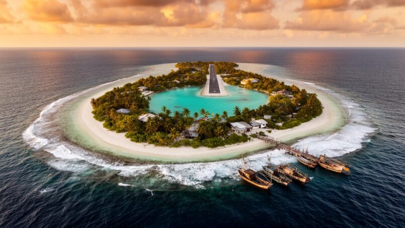
Tuvalu consists of nine inhabited islands, stretching between 6° and 10° south latitude in the Pacific. Six are “true” atolls (Funafuti, Nanumea, Nui, Nukufetau, Nukulaelae, Vaitupu), and three are raised reef islands (Nanumaga, Niutao, Niulakita). All rest on coral formations, remnants of sunken volcanoes or carbonate shoals sculpted by sea level variations.
The topography is of extreme fragility: the average elevation is less than 2 m, with the highest point on Niulakita reaching 4.6 m. On several islets, the strip of land is sometimes only a few tens of meters wide; at Funafuti, where the capital is concentrated on Fongafale Islet, the average width is around 100 m, with sections so narrow they can only accommodate a road.
This narrowness is reflected in the numbers: the total area of Funafuti’s 33 islets is only 2.4 km², less than 1% of the atoll’s area, the rest being occupied by the lagoon, which covers about 275 km² and reaches over 50 m deep in its northern basin.
Living Atolls, Mobile Geographies
Tuvalu’s atolls are not fixed rock pieces but living structures built by coral reefs and biogenic sands (coral debris, foraminifera, shells). Over decades, the coastline advances and retreats, sand spits shift, some islets gain area, others lose it.
The land area of 101 islands and islets increased by about 73.5 hectares over four decades, a rise of 2.9%.
This dynamic is linked to how sea level rise alters the transfer of wave energy across reef flats: more water on the reef means more powerful waves that move more sand, sometimes toward the shores of islets. But this “accretion” does not mean the country gains habitable land. As former Prime Minister Enele Sopoaga noted, the new surfaces are often unstable, exposed, or unsuitable for building homes and infrastructure.
A Mosaic of Coastal and Marine Environments
Around the islands unfolds a set of highly diverse marine environments, on which the geographic stability of the archipelago directly depends. Studies distinguish several major ecosystem types: outer reefs exposed to the open ocean, inner lagoons, intertidal reef flats, natural channels connecting ocean and lagoon, lagoon floor areas, and, in some zones, coastal mangroves.
Reefs harbor over 600 species of fish, but coral cover is low, reaching only 15% at Funafuti, with a decline observed compared to previous decades, worsened by bleaching affecting up to 80% of corals and 70% destroyed after Cyclone Tino at Nui.
Reefs play a crucial geographic role: they dissipate wave energy, produce the sand that feeds carbonate beaches, and contribute to the vertical growth of the atoll. However, at Tuvalu, reef growth is slow, on the order of 2 mm per year, a pace that may no longer keep up if sea level rise accelerates or if corals are permanently weakened by bleaching and acidification.
Poor Soils, Scarce Land
On land, geography faces another structural challenge: the near absence of fertile soils. The islands are composed of carbonate materials, young, coarse, very porous, with poor structure and water retention capacity. pH is high, between 8.2 and 8.9, which limits the availability of many trace elements (iron, zinc, manganese, copper, etc.). There are no mountains, valleys, or rivers: only sand ridges, narrow storm dunes on the ocean side, and sometimes small depressions or filled-in former swamps.
This geography immediately rules out any intensive agricultural ambition. The main features are:
– exploited coconut groves (about 43% of vegetation cover);
– agroforests mixing coconut, pandanus, banana, breadfruit trees, and kitchen gardens;
– a few remnants of native broadleaf forests (barely over 4% of vegetation), a large part of which is protected in the Funafuti Conservation Area.
Subsistence agriculture includes growing pulaka, a local giant taro (Cyrtosperma chamissonis), in pits dug down to the freshwater table. These pits require intensive digging and organic matter input, and it often takes several years to obtain a tuber of respectable size.
But this agricultural system depends directly on underground geography: the position and thickness of the freshwater lens, and its salinity. At Funafuti, conductivity analyses show values of 4,000 to 5,000 μS/cm in the pits, well above the threshold considered compatible with good pulaka growth. As a result, cultivation has largely ceased on Fongafale, and residents increasingly rely on imported products, losing part of their food heritage in the process.
An Increasingly Fragile Land–Sea Interface
The geography of Tuvalu is first and foremost a geography of the interface. Most homes, roads, schools, and infrastructure are built along the coast, on strips of land raised only a few tens of centimeters above mean sea level. With every cyclone, every “king” spring tide, this boundary is redrawn.
Sea Level Rise: Millimeters That Change Everything
Globally, mean sea level rose by about 10 to 20 cm in the 20th century, and IPCC scenarios project a rise of 0.09 to 0.88 m by the end of the 21st century. But around Tuvalu, the regional signal is stronger: satellite altimetry and tide gauge data converge on a rise of about 4.7 to 5 mm/year since 1993, or about 14 to 15 cm over three decades, a rate roughly 1.5 to 2 times the global average.
Recent projections indicate:
– a relative rise of 0.20 to 0.30 m by 2050 (relative to 2005), regardless of emissions scenario;
– between 0.5 and 1 m by 2100 in medium scenarios, with an upper bound, in the case of rapid ice sheet loss, near 2 m.
Even a modest 10 cm sea level rise makes the airstrip and adjacent areas of Funafuti vulnerable to recurrent flooding, as most land lies below 2 m elevation and the inundation threshold is crossed more often.
Flood frequency models show that with about 30 cm of rise (plausible around 2050), the “low” inundation threshold (50 cm above mean high water) would be reached between 35 and 80 days per year. With an additional 70 cm by 2100, Tuvalu could experience more than 100 days of inundation per year if no additional protection is implemented.
Cyclones, Distant Swells, and “Blue Sky” Events
Tuvalu has always known storms and swell inundations. Cyclones like Bebe (1972), Meli (1979), or more recently Pam (2015) and Tino have shown the potential violence of these events, capable of stripping vegetation and sweeping away almost the entire sand layer of an islet like Tepuka Vili Vili. But sea level rise changes the scale of impacts.
When the sea is a few tens of centimeters higher, the water depth over the reef increases, allowing higher waves to cross the reef flat and strike the shore directly. This phenomenon is not limited to nearby cyclones: swells generated by distant storms can now cause washovers on already weakened coasts, sometimes under perfectly clear skies, hence the term “blue sky events.”
Blue sky events phenomenon
Risk assessments highlight that: risk factors must be identified and analyzed systematically.
– a decadal wave event during a cyclone could inundate major coastal infrastructure, with a very low survival probability for residents in those areas;
– with only 0.5 m of sea level rise, the probability of such extreme events could double;
– by 2050, according to some models, 60% of the population could be exposed to coastal inundation under a low-emissions scenario, and up to 80% under a high-emissions scenario.
Coastal Erosion and Failed Redevelopments
Sea level rise does not only result in more frequent flooding; it also accelerates erosion. On Fongafale, beach profile surveys show that erosion dominates accretion along most of the lagoon front. Scarp edges 20 to 50 cm high cut into the vegetation line, evidence that the sea is nibbling away at the beaches.
Recent geomorphological changes such as channel dredging, landfilling, sand extraction, and construction (dikes, jetties, causeways, ports) alter sediment flows and worsen erosion. At Funafuti, a causeway interrupted sand supply to beaches; at Vaitupu, a port built in the 1990s increased erosion; at Nukufetau, a protective wall caused complete erosion of the opposite end of the island.
Regional experience shows that conventional hard structures—vertical walls, massive dikes—are poorly suited to the mobile nature of atolls. These structures reflect wave energy, which combines with incident waves, sometimes doubling water depth at the structure’s base. They also cut off sediment supply from the backshore during storms, shifting erosion to unprotected sections. In several Pacific cases, reclaimed land protected by dikes eventually turned into sterile salt marshes a few decades later.
At Tuvalu, this tension is evident: on one hand, anxiety justifies projects like the Tuvalu Coastal Adaptation Project (TCAP), which extends hard protections along nearly 2.8 km of coastline at Funafuti, Nanumea, and Nanumaga; on the other hand, national studies acknowledge that dikes can constitute “maladaptations,” creating more problems in the long run than they solve.
Freshwater: An Invisible but Vital Geography
If the boundary between land and sea is at the heart of concerns, the most decisive geography for Tuvalu’s future is perhaps invisible to the naked eye: that of the freshwater lenses floating on saltwater, within the coral deposits.
Subsurface Lenses and Saltwater Intrusion
On an atoll, rainwater quickly infiltrates the porous substrate and forms a freshwater lens “perched” above the denser marine saltwater. Between the two lies a brackish transition zone. The thickness and extent of this lens depend directly on:
– rainfall amount (and its seasonal variability);
– plant evapotranspiration;
– water extraction by humans (wells, pumping);
– the pressure exerted by the surrounding sea.
Freshwater lenses in Tuvalu are shallow and highly vulnerable to sea level rise. Saltwater infiltration occurs during storm surges, spring tides, or gradual sea level rise. On Fongafale, salty water bubbles up through the coral at high tide, flooding areas normally above water.
The risks associated with saltwater intrusion into these reservoirs are multiple:
– water quality degrades: it becomes brackish then frankly salty, unfit for consumption;
– the lens thins, reducing the extractable volume for crop irrigation;
– the frequency of inundation events limits the lens’s ability to recover between events.
Modeling combining climate projections and hydrogeological parameters indicates dramatic reductions in lens volume with sea level rise: a 0.25 m rise could reduce the lens by about 25%, 0.5 m rise by 50%, and 1 m by up to 80%. In the long term, this means that even if the land remains above water, freshwater reserves could become insufficient to sustain viable human life.
Droughts, Erratic Rainfall, and Dependence on Rain
Tuvalu has no rivers or lakes. Historically, rainwater collected from rooftops and stored in tanks supplemented the use of groundwater, often too salty to drink but still usable for some domestic or agricultural purposes.
With the degradation of freshwater lenses, rain becomes the almost exclusive source of drinking water. Rainfall is increasingly irregular due to climate change and ENSO variability. During La Niña periods, severe droughts can occur, as in 2011, when a drought triggered a state of emergency and forced reliance on mobile desalination units and bottled water deliveries.
Vulnerability assessments highlight that today up to 70% of residents lack sufficient storage capacity to cope with prolonged dry periods. In this context:
– water availability is already classified as “major risk“;
– water quality is also assessed as “major risk“;
– these risks are expected to increase further by 2030 and become “extreme” around 2050, with repercussions for public health, food security, and cultural practices (e.g., pulaka cultivation).
Coastal flooding events worsen the situation by causing septic tank overflows, clogging pumps and drains with sediment and debris, and infiltrating wastewater into the lenses, turning the scarce freshwater resources into potential vectors of waterborne diseases.
A Geographic Economy: Between 26 km² of Land and 900,000 km² of Sea
The geography of Tuvalu is not limited to emerged islands. The country exercises sovereign rights over a vast Exclusive Economic Zone (EEZ) of about 750,000 to 900,000 km², more than 30,000 times its land area. This sea, rich in fishery resources, is a central economic asset through the sale of fishing licenses, and potentially through marine energy (wind, currents) and possible fossil fuel deposits.
Sea level rise could submerge the islands that serve as baselines for maritime boundaries. Under current law of the sea, the Exclusive Economic Zone (EEZ) is tied to the existence of natural islands above water at high tide. Their disappearance would therefore threaten sovereignty over associated maritime spaces.
Anticipating this scenario, Tuvalu adopted a constitutional reform in 2023 affirming its state continuity even in the event of the disappearance of its physical territory, and the permanence of its maritime limits as declared in its maritime zones laws and boundary agreements (with Kiribati, Fiji, France for Wallis-and-Futuna). The country is also involved in initiatives like the Commission of Small Island States on Climate Change and International Law (COSIS), which advocates that maritime zones should not be reduced by sea level rise.
Geographic Adaptation: Between Walls, Sands, and Alternative Geometries
Faced with sea level rise and the destabilization of land–sea and freshwater–saltwater interfaces, Tuvalu is undertaking a series of responses that transform the country’s geography. Three main lines emerge: hardening shorelines, raising and expanding certain lands, and rethinking how to inhabit shifting spaces.
TCAP: Protect, Raise, Buy Time
The Tuvalu Coastal Adaptation Project (TCAP), launched in 2017 with US$36 million in funding from the Green Climate Fund and a state contribution, is the centerpiece of this adaptation strategy.
The project aims to: promote sustainable development and improve the quality of life of local communities.
– protect about 2,780 m of coastline at Funafuti, Nanumea, and Nanumaga, compared to 570 m previously protected;
– reduce exposure to flooding for about 29% of the population, i.e., 3,100 direct beneficiaries and nearly 3,500 indirect beneficiaries (about 62% of the population);
– limit annual economic losses from coastal flooding, estimated at several hundred thousand dollars over 40 years.
Interventions are tailored to local contexts:
Three distinct approaches to protect the islands from erosion and sea level rise
Burying berm top barriers (geotextile containers filled with sand) along the dune, adding 1.5 m in height. Stabilization through revegetation (coconut, pandanus) and a wooden walkway.
Construction of a new wall using Seabee hexagonal blocks (precast concrete) to protect 160 m of coastline in front of the church area.
Radical strategy: construction of a large reclaimed platform on the lagoon, adjacent to Fongafale.
Remaking Geography: Funafuti’s “Reclaimed Land”
On Fongafale, the most visible project involves creating an artificial strip of land 780 m long and 100 m wide, i.e., 7.8 ha reclaimed from the lagoon. Sand is dredged from the lagoon, stockpiled, and compacted to form a plateau with an elevation designed to remain above projected sea levels and wave attack beyond 2100.
The lagoon-side edges of this new land are consolidated by a retaining wall and groins made of giant sandbags. The land will then be developed to accommodate infrastructure or housing, with a drainage system sized to handle rainwater.
This “Reclaimed Land” illustrates the ambivalence of adaptation in Tuvalu:
The extension increases Fongafale’s usable area by about 8%, offering some room to maneuver in the face of overcrowding and the shortage of safe land.
Initial observations of earlier developments—such as the park created from filling former borrow pits at Funafuti, already described as “highly eroded” less than a year after its creation—show that these artificial geometries are not inherently stable. The adjacent beach quickly migrated, demonstrating the difficulty of “fixing” a coastline on a living atoll.
Toward “Resilient Edges”: Working with Geography Rather Than Against It
Given the limits of hard solutions, another approach is emerging, more in tune with the intrinsically mobile geography of atolls and with Tuvalu’s traditional knowledge.
Historically, Tuvaluan dwellings were designed for mobility: lightweight stilt houses, wooden structures and thatched roofs, easily dismantled or rebuilt further inland after an extreme event. Colonizers and then modernizers introduced a logic of fixed land ownership and massive permanent buildings, poorly suited to an environment whose stability is never guaranteed.
So-called “eco-technical” projects have attempted to reconnect with the living nature of atolls, seeking to restore their natural dynamics and biodiversity.
– a research program supported by Japan tested the stimulation of foraminifera sand production in the lagoon, to naturally nourish beaches rather than fixing them with concrete;
– mangrove replanting campaigns, for example at Nanumea, aim to recreate vegetated belts capable of dissipating part of the wave energy and trapping sediments;
– work on ethnobotany highlights salt-tolerant indigenous species (such as Scaevola taccada or Pandanus tectorius), whose root systems and physiology help limit erosion and buffer soil salinity around pulaka pits.
These “soft edges” are not a panacea: mangroves need space to migrate inland as the sea rises, which presupposes not systematically building or filling the back-dune; technical projects like stimulating lagoon sedimentology are difficult to explain to communities and to integrate into political timelines. But they pave the way for an adaptation that does not boil down to thickening walls, at the risk of confining the atoll in a kind of concrete “iron lung.”
A Global Laboratory for Climate Geographies
The geography of Tuvalu, as it is being redrawn before our eyes, concerns not only a state of 11,000 inhabitants. It raises fundamental questions about how human societies inhabit rapidly changing spaces.
A few trends clearly emerge from scientific work and local observations:
Sea level has risen by 14 to 15 cm at Funafuti in thirty years, with an expected acceleration to 8 mm/year by 2050.
In this context, Tuvalu becomes a laboratory—or a magnifying mirror—for other coastal regions: how to manage the coexistence of legal boundaries (EEZ lines), physical boundaries (unstable coastlines), and invisible boundaries (freshwater lenses, salinized soils) in a world where sea level will not return to past values?
In Tuvalu, geography goes beyond maps: families move their gardens inland to escape saltwater, villages hesitate between building a wall or letting the beach retreat, and the state digitizes its landscapes to preserve memory and defend its rights despite coastal erosion.
In this tiny archipelago, the frontier between land and sea, between habitable and uninhabitable, becomes the stage where the great questions of the century play out: How far can we adapt our geographies? And from what point will we need to redraw, elsewhere, new places to live for those whose original territories will have been submerged, salinized, or rendered unlivable?
A heritage project or a question? Contact us now to exchange with an expert in wealth management.
Disclaimer: The information provided on this website is for informational purposes only and does not constitute financial, legal, or professional advice. We encourage you to consult qualified experts before making any investment, real estate, or expatriation decisions. Although we strive to maintain up-to-date and accurate information, we do not guarantee the completeness, accuracy, or timeliness of the proposed content. As investment and expatriation involve risks, we disclaim any liability for potential losses or damages arising from the use of this site. Your use of this site confirms your acceptance of these terms and your understanding of the associated risks.

Cyril Jarnias is an independent expert in international wealth management with over 20 years of experience. As an expatriate himself, he is dedicated to helping individuals and business leaders build, protect, and pass on their wealth with complete peace of mind.
On his website, cyriljarnias.com, he shares his expertise on international real estate, offshore company formation, and expatriation.
Thanks to his expertise, he offers sound advice to optimize his clients' wealth management. Cyril Jarnias is also recognized for his appearances in many prestigious media outlets such as BFM Business, les Français de l’étranger, Le Figaro, Les Echos, and Mieux vivre votre argent, where he shares his knowledge and know-how in wealth management.





