
 Published on and written by Cyril Jarnias
Wedged between the Red Sea, mineral desert, and mountains suspended above heat haze, Djibouti packs a density of landscapes and experiences into a tiny territory that surprises even seasoned travelers. Still largely unknown, this country on the Gulf of Aden boasts surreal salt lakes, a “brand new” volcano, some of the richest seabeds in the Indian Ocean, a relict forest lost at altitude, and coastal towns steeped in history.
Tourism in Djibouti offers a unique experience blending spectacular geological landscapes (Afar Depression, smoking chimneys), encounters with marine life (swimming with whale sharks), and cultural immersion with the Afar nomads. The visit stretches from the capital to the country’s iconic natural sites.
Djibouti, a crossroads of tectonic plates and cultures
Located in the Horn of Africa, at the precise point where the Red Sea meets the Gulf of Aden, Djibouti sits on the convergence of three major tectonic plates (Nubian, Somali, and Arabian). This unique geological context alone explains the variety of the country’s remarkable sites: salt lakes below sea level, endless black lava fields, recent volcanoes, gaping faults, and hot springs.
The country is part of the Great Rift Valley and the Afar Depression, one of the hottest and driest areas on Earth. Part of its territory lies below sea level, creating spectacular, almost alien landscapes, such as those seen at Lake Assal or Lake Abbe.
This mineral harshness contrasts with the lively life of Djibouti City, the port capital where African, Arab, and French influences blend. Mosques, churches, colorful markets, a seaside corniche, and colonial neighborhoods recall that the city long served as a key stopover on maritime routes connecting Europe, the Suez Canal, the Arabian Peninsula, and the Indian Ocean.
Djibouti City, gateway to the natural wonders
The starting point for virtually all excursions, Djibouti City concentrates most of the country’s tourist infrastructure. It houses nearly 90% of accommodations, from upscale hotels like Djibouti Palace Kempinski or Sheraton Djibouti to more affordable options such as Hotel Les Acacias, Atlantic Hotel, or budget guesthouses.
A human-scale capital, between mosques and the central market
The city is easily explored on foot or by taxi. The European quarter, inherited from the colonial period, lines up administrative buildings, embassies, former trading houses, and churches like Sainte-Anne. Nearby, Menelik Square (Place Menelik) serves as the nerve center, surrounded by cafes and shops. Further south, the African quarter extends the commercial heart, all the way to the grand market.
The Central Market, Rimbaud Square, and the Great Fishery are essential places to grasp the city’s identity. You’ll find local handicrafts (textiles, futas, Afar and Somali jewelry), local products (spices, fruits, salt crystals from Lake Assal), and the importance of the Red Sea, illustrated by the fish stalls, in the diet.
Iconic mosques – Hamoudi, Al Sada, Al Molk, or the Grand Mosque – punctuate the urban skyline. Their minarets signal the city’s anchoring in the Muslim world, while the presence of Orthodox and Catholic churches recalls the diversity of communities.
Comparison tables: main urban points of interest
To organize your exploration, it’s useful to distinguish cultural and religious sites from promenade areas.
| Type of site | Location / Neighborhood | Main feature |
|---|---|---|
| Square and promenade | Menelik Square, Corniche | Lively heart, cafes, Red Sea views |
| Markets | Central Market, Rimbaud Square | Textiles, spices, handicrafts, daily life |
| Religious heritage | Hamoudi Mosque, Sainte-Anne | Islamic and colonial architecture, places of worship |
| Iconic buildings | Presidential Palace, People’s Palace | Political symbols, monumental architecture |
| Culture and museums | National Museum, Rimbaud Center | History, arts, literary memory |
In the evening, restaurants like Restaurant La Chaumière, Pizzaiolo Central, or addresses serving Djiboutian, Chinese, Indian, or Lebanese cuisine allow you to sample the country’s culinary blend: Red Sea fish, skoudehkaris (rice and meat dish), samboussas, lahoh, or Yemeni-inspired dishes.
From Djibouti City, roads and ferries then radiate toward the country’s major sites, from Lake Assal to the islands of Moucha and Maskali, from the Day Forest to the beaches of Arta or Khor Ambado.
Lake Assal, salt jewel at the lowest point in Africa
It’s hard to imagine a more striking visit than Lake Assal. Located about 100–120 km west of Djibouti City, this hypersaline crater lake occupies a depression about 150–155 meters below sea level. It is the lowest point on the African continent and one of the deepest depressions on the planet after the Dead Sea region.
An unreal landscape of salt and black lava
The journey from the capital first takes national road RN1, then RN9, before plunging into an increasingly mineral landscape. The road, initially paved, runs along canyons like Dimbiya, sometimes called the “Grand Canyon of Djibouti,” then overlooks the Ghoubbet Bay, before reaching the Lake Assal depression. A 4×4 remains recommended, especially to leave the main road and get closer to the shores.
Approaching the lake, the landscape presents a striking contrast between fields of black basaltic lava, solidified flows and extinct volcanic cones, and the blinding white surface of the lake, edged with emerald or turquoise water. The shore is entirely encrusted with salt, and the rocks are covered in a thick crystalline crust.
The extraordinary composition of the lake makes it saltier than the Dead Sea, with a salt content reaching up to 35% and salinity far higher than that of the ocean. The solid part of the lake, a vast salt plateau up to 60 meters thick, coexists with a deeper brine zone, making Lake Assal one of the largest salt reservoirs in the world.
A place of life, commerce, and spirituality
Despite the extreme conditions, the site is far from deserted. For the Afar people, Lake Assal is both a major economic resource and a place charged with meaning. For centuries, they have extracted salt here, first traditionally and then using more modern techniques. The blocks, once loaded onto camel caravans bound for Ethiopia, remain a valuable trade item, even if road transport has taken over.
The lake is considered a sacred place by some, attributed with therapeutic virtues. Its mystical atmosphere, marked by particular light and colors, as well as absolute aridity, is especially intense at sunrise or sunset. Visitors often take home iconic souvenirs of Djibouti, such as salt crystals or rocks covered in salt deposits.
Lake Assal: practical information
| Element | Key information |
|---|---|
| Distance from capital | About 100–120 km (2 to 3 hours by road) |
| Altitude | About -150 to -155 m (lowest point in Africa) |
| Access | Road RN1 + RN9, 4×4 recommended |
| Environment | Lava fields, extinct volcanoes, tectonic faults |
| Activities | Walk on the salt flats, floating swim, photography, meeting the Afar, salt caravan |
| Souvenirs | Salt crystals, saline rocks |
Many day trips combine Lake Assal, Ghoubbet Bay, and an approach to the Ardoukoba volcano, allowing you to read millions of years of geological history in a few hours.
Lake Abbe, mineral cathedral at the end of the desert
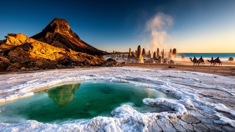
At the opposite southwest end of the country, on the border with Ethiopia, lies another major site: Lake Abbe. Here again, the surprise comes from the shape the landscape takes. No uniform turquoise mirror here, but a vast plain dotted with hundreds of limestone chimneys – tufas – that can reach up to 50 meters in height.
A “foreign planet” between hot springs and fumaroles
Lake Abbe is part of an interconnected lake system in the Afar Depression. Over time, irregular water inflows and upstream withdrawals (notably along the Awash River in Ethiopia) have caused the main body of water to recede, exposing vast expanses of mudflats and mud. This retreat has revealed the limestone structures formed by hot springs and fumaroles.
The chimneys, like petrified organ pipes, are the result of rising steam and dissolved minerals that, as they deposited, built these hollow columns. At night, jets of hot steam still escape from some places, heightening the unreal atmosphere. It is precisely this setting that served as a backdrop for scenes from films like “Planet of the Apes.”
Geological description
Wildlife and end-of-the-world atmosphere
Despite the drought, the region hosts diverse wildlife: flamingos and pelicans take advantage of the mudflats to feed, while ibises, ostriches, gazelles, or hyenas occupy the desert edges. In the morning, flocks of flamingos stand out against a milky sky, in a light that blurs the horizon’s contours.
The site is usually visited with a guide and a 4×4 from Djibouti City, after a drive of over five hours. Camping is almost mandatory, as permanent accommodations are scarce. These constraints help preserve the lake’s raw and isolated character, making it one of the most spectacular and least visited sites on the continent.
| Aspect | Lake Assal | Lake Abbe |
|---|---|---|
| Position | Central-west, near the Gulf of Tadjoura | Southwest, Djibouti–Ethiopia border |
| Specificity | Lowest point in Africa, hypersaline lake | Limestone chimneys, hot springs, lunar landscape |
| Access | 2–3 h by car, mostly paved road | Over 5 h by 4×4, track, camping required |
| Activities | Walk, photography, meeting the Afar, floating swim | Hike around tufas, flamingo watching, sunrise/sunset |
Together, Lake Assal and Lake Abbe form an unmissable geological diptych during a trip to Djibouti.
Ghoubbet Bay and Ardoukoba Volcano: at the heart of the Rift
At the western end of the Gulf of Tadjoura, Ghoubbet Bay (Ghoubbet al-Kharab), sometimes called “the devil’s throat,” offers one of the finest condensations of the tectonic dynamics at work in Djibouti. This small inland sea, surrounded by cliffs of black lava up to several hundred meters high, marks the junction zone between the Assal depression and the gulf.
Ghoubbet, kingdom of whale sharks and underwater faults
Ghoubbet Bay communicates with the Gulf of Tadjoura through a narrow passage where currents are violent. These water exchanges, combined with the underwater topography, create nutrient upwellings that attract exceptional marine life. Between November and February, juvenile whale sharks – the largest fish in the world, sometimes ten meters long – come to feed on plankton in these waters.
Observation cruises and guided snorkeling allow you to swim with the whales while respecting strict rules: limited number of people in the water, minimum distance to maintain, prohibition of touching the animals, and control of boat speed. Meanwhile, divers can explore unique underwater sites such as faults, drop-offs, and canyons, which testify to the fragmentation of the Earth’s crust.
Ardoukoba, “baby volcano” above the lava fields
Between Ghoubbet Bay and Lake Assal rises the Ardoukoba volcano, considered one of the youngest volcanoes in the world. It was born from a week-long fissural eruption in November 1978, after some 3,000 years of calm in this segment of the rift. Its modest cone – about 40 meters high, with a summit at 298 meters altitude – conceals a fascinating geodynamic story.
Twelve million cubic meters of lava were emitted, reshaping the landscape into a vast black lava field.
Today, you can walk on these solidified flows and literally cross the fault line where the plates separate. A trail leads to the edge of the crater, about a two-hour walk from where the 4x4s stop. From up there, the view encompasses the Manda lava plain, the salty shores of Lake Assal, and the cliffs plunging into Ghoubbet.
Essential info on Ghoubbet and Ardoukoba
| Element | Ghoubbet Bay | Ardoukoba Volcano |
|---|---|---|
| Location | Western end of the Gulf of Tadjoura | Between Lake Assal and Ghoubbet Bay |
| Main interest | Whale sharks, drop-offs, currents, volcanic landscapes | Recent volcano, lava fields, rift views |
| Altitude | Sea level | Summit at ~298 m |
| Access | Road from Djibouti City, 4×4 advised | 4×4 track then hike (about 4 h round trip) |
| Activities | Diving, snorkeling, whale shark watching, coastal hiking | Hiking, geological observation, photography |
For earth science enthusiasts, this region – considered by some researchers as an open-air laboratory on ocean opening – is simply unmissable.
The Gulf of Tadjoura and Djibouti’s underwater treasures
If the land landscapes fascinate, it is often the seabeds that alone justify a trip to Djibouti. With nearly 400 km of coastline, a semi-enclosed gulf, and several marine protected areas, the country has become an increasingly sought-after destination for divers and snorkelers.
A sanctuary for corals, whale sharks, and dolphins
The waters of the Gulf of Tadjoura and the Bab el-Mandeb Strait are enriched by vigorous currents and tides that promote the growth of very dense coral reefs. There are over 200 species of corals, sheltering varied fauna: green turtles, manta rays, stingrays, reef sharks, schools of barracudas, groupers, jacks, butterflyfish, damselfish, triggerfish, moray eels, and a host of macroscopic species like nudibranchs and shrimp.
Djibouti has classified several areas as marine protected areas, notably around the islands of Moucha and Maskali, the Arta sector, and the Sept Frères (Seven Brothers) archipelago, a group of six volcanic islands and the Ras Siyyan peninsula. These measures aim to regulate fishing and reduce poaching, while developing respectful ecotourism.
Water temperature remains warm year-round, allowing the use of a light wetsuit for diving.
Moucha, Maskali, and beaches near the capital
Facing Djibouti City, in the Gulf of Tadjoura, the islands of Moucha and Maskali make an ideal day trip or two-day excursion. About a thirty-minute boat ride away, you’ll discover white sand beaches fringed with mangroves, coral reefs in excellent condition, and cobalt waters where dolphins frequently appear.
The waters around Moucha offer several dive sites accessible to all levels. “The Aquarium,” for example, lives up to its name, with an abundance of colorful reef fish. Other sites offer wreck dives, such as the Faon / MV Priamos, a cargo ship lying between 10 and 30 meters deep, now covered in sponges and gorgonians.
Near the capital, the beaches of Dorale and Khor Ambado (15 km away) offer swimming in clear water at the foot of lava cliffs. Khor Ambado is known for its light sand, calm waters, and small beach restaurants. Further west, Arta Beach (about 1h30 drive) is a prime spot for observing whale sharks from the coast, although its pebble and rock beach is less comfortable for relaxing.
The Sept Frères Archipelago, paradise for dive cruises
Further north, toward the Bab el-Mandeb Strait, the Sept Frères (Sawabi) archipelago concentrates some of the finest dive sites in the country. Powerful currents, vertiginous drop-offs, teeming reefs, and historic wrecks, such as an Italian submarine sunk in 1940, attract the most experienced divers. Week-long dive cruises, which typically combine Sept Frères and the Gulf of Tadjoura, are considered the best way to fully enjoy these isolated spots, which have no land-based accommodations.
| Marine zone | Main features | Common form of visit |
|---|---|---|
| Gulf of Tadjoura | Coral reefs, turtles, reef sharks, varied sites | Shore diving and day cruises |
| Moucha & Maskali | Beaches, mangroves, rich reefs, dolphins | Boat excursion, snorkeling, diving, camping |
| Ghoubbet Bay | Juvenile whale sharks, mantas, underwater tectonic faults | Specialized whale shark trips, diving |
| Sept Frères Archipelago | Currents, large pelagics, historic wrecks | Liveaboard dive cruises |
Between dives, some cruises include a land excursion to Lake Assal or the Day Forest, creating a subtle balance between water sports and desert exploration.
Day Forest and Goda Mountains: a green oasis suspended above
When you leave the burning coast and head north inland, the Goda Mountains gradually emerge. At about 1,500 meters altitude, an unexpected pocket of greenery appears in the middle of arid landscapes: the Day Forest, the only large forest massif in the country and the only officially recognized national park.
A relict forest from another age
Classified as early as 1939, the Day Forest represents a vestige of the vegetation that once covered parts of the Sahara and the Arabian Peninsula before aridification. Its slopes are covered with East African junipers (Juniperus procera), sometimes twenty meters high, wild olives, boxwood, acacias, fig trees, and rarer species such as the Nubian dragon tree (Dracaena ombet) or the Bankoualé palm (Livistona carinensis).
This massif is a biodiversity reservoir and an essential water catchment area. It serves as a refuge for many animal species that could not survive in the surrounding deserts.
A paradise for birdwatchers and hikers
The Day Forest and its surroundings host over 360 species of birds. The most emblematic species is undoubtedly the Djibouti francolin, a small endemic galliform in critical danger of extinction, which now only survives in this massif and a few neighboring pockets. Other rare birds, such as the Egyptian vulture, various falcon species, the European roller, or colorful passerines, also find refuge here.
The massif hosts a diversity of mammals such as hamadryas baboons, cercopithecus monkeys, gazelles, warthogs, Grévy’s zebras, as well as more discreet predators like hyenas, jackals, and leopards. Trails, particularly between Day and Bankoualé, allow you to discover this preserved environment, benefiting from a cooler climate than the plains.
The hikes, sometimes spectacular when they run along deep gorges or basalt cliffs, offer sweeping views of the Gulf of Tadjoura and, on clear days, as far as the Sables Blancs beach near Tadjoura.
Logistics and mountain accommodations
Access to the Day Forest is from Djibouti City in about 2 to 3 hours by car, including a final stretch on a track requiring a 4×4. There are no conventional hotels or restaurants inside the park, but simple tourist camps – such as the Day Forest Camp, Dittilou Camp, or Bankoualé Camp – welcome visitors in rustic but clean huts or bungalows, with meals prepared on site.
| Feature | Day Forest and Goda Mountains |
|---|---|
| Average altitude | About 1,000–1,500 m |
| Forest area | Several hundred hectares of junipers and olives |
| Emblematic species | Djibouti francolin (endemic, critically endangered) |
| Activities | Hiking, wildlife and plant observation, visiting Afar villages |
| Accommodation | Rustic camps (Dittilou, Bankoualé, Day) |
The best time to visit this massif is from October to March, when temperatures are pleasant. In the heart of summer, the oppressive heat on the plains and the risk of rain make access more difficult.
Grand Bara deserts and Hanlé plains: the country’s other face
Beyond the salt lakes and wooded mountains, Djibouti holds vast deserts of clay plains, such as the Grand Bara and the Petit Bara. These flat expanses, framed by granite reliefs, evoke the surface of a dried-up lake, where winds sculpt swirls of dust.
Located near the Ethiopian border at about 760 meters altitude, the Grand Bara is the site of an annual 15 km marathon. The area also attracts land sailing enthusiasts and photographers, especially at dawn or dusk when the raking light creates geometric shadows on the cracked ground. One can sometimes spot gazelles, their furtive silhouettes standing out against the horizon.
Further south, the Hanlé plain borders the Goba’ad plain, known for its freshwater lakes and marshes, a paradise for many bird species like Egyptian geese, black crakes, or three-banded plovers. Here again, the interest lies in the combination of wildlife observation, open landscapes, and traces of very ancient human occupation, with ruins and funerary tumuli.
White towns and northern coasts: Tadjoura and Obock
On the northern shore of the Gulf of Tadjoura, the small towns of Tadjoura and Obock offer another face of Djibouti: that of quiet ports, whitewashed houses turned toward the sea, and centuries-old mosques.
Tadjoura, sometimes called the “white city,” is one of the oldest towns in the country. Its narrow alleys, low buildings, its former sultan’s palace now converted into a museum, its 19th-century mosques built of coral stone, and its waterfront make it a charming stopover. The neighboring beaches, like Sables Blancs, are among the most beautiful on the coast, ideal for snorkeling, diving, or artisanal fishing.
The Ras Bir lighthouse, attributed to engineer Gustave Eiffel, was built on a cliff in 1917.
These towns are accessible by ferry from Djibouti City, via the L’Escale port, or by road along the southern shore of the gulf. They serve as bases for venturing to the Day Forest, Sables Blancs, Bankoualé, or some less frequented dive sites.
Wildlife reserves and mangroves: protected biodiversity
Alongside the major landscapes already mentioned, Djibouti is setting up structures for the protection of its fauna and habitats.
South of the capital, the Decan Wildlife Refuge collects and rehabilitates wild animals victims of trafficking or injuries: cheetahs, lions, zebras, antelopes, ostriches, monkeys, and various birds find a second chance there. This site, managed by a veterinarian, allows close observation of some emblematic species of the region and raises awareness of conservation issues.
Mangroves, like those of Godoria, are vital for migratory birds, serving as stopovers and feeding grounds for millions of individuals on the Eurasia-Africa flyways. These ecosystems also protect coasts from erosion and host a rich aquatic fauna.
In the mountains, protection initiatives concern not only the Day Forest but also other massifs like Mabla or Arrei, where pockets of natural vegetation and wildlife migration corridors persist.
Djibouti, land of ancient history and rock art
Beyond the landscapes, Djibouti is also a country of history, with about 7,000 years of documented human presence. Part of this past is read in rock art sites and archaeological ensembles still little known to the public.
<!– wp:group {"className":"custom-block-example background-example","layout":{"type":"constrained"}}The site of Abourma, near Randa, presents over 1.5 km² hundreds of millennia-old engravings depicting giraffes, antelopes, ostriches, and scenes of life. Other areas like Balho and the Goba’ad plain also preserve engravings and ancient tombs, illustrating the central role of the region in prehistoric pastoralism and exchange networks.
These sites, difficult to access, require a 4×4, an experienced guide, and sometimes special permits, but they perfectly complement the discovery of the great natural icons, recalling the temporal depth of human occupation in the Horn of Africa.
Practical tips and sustainable dimension of visits
Exploring the must-see tourist sites in Djibouti means dealing with an extremely hot and dry climate for much of the year. The most pleasant period is generally between November and February, when temperatures are slightly milder, whether for mountain hiking, desert excursions, or diving.
Due to road conditions and the isolation of sites like Lake Abbe, the Day Forest, rock art sites, or Ardoukoba, it is highly recommended to use a 4×4 vehicle with driver and local guides. Several specialized agencies (dive operators, trekking agencies) organize custom tours, itineraries combining sea and desert, and liveaboard dive cruises with land extensions to Lake Assal or the mountains.
Accommodation remains very concentrated in Djibouti City, where most hotels are found, from luxurious to basic. In the north (Tadjoura, Obock), the offer is limited to small structures and guesthouses, while in the Assal, Abbe, or highland regions, camping or community camps are often the only solution.
The fragility of Djibouti’s ecosystems requires increased vigilance: avoid picking corals, minimize your impact on the salt flats, respect approach distances with wildlife (whale sharks, birds, antelopes), and leave no waste in isolated areas. Favor existing ecotourism initiatives, such as village camps or excursions with local Afar or Issa guides, who offer stays focused on respectful observation rather than consumption. These choices directly contribute to preserving this unique natural heritage.
—
From the hypersaline depths of Lake Assal to the juniper forests of the Goda Mountains, from the lava flows of Ardoukoba to the coral reefs of the Gulf of Tadjoura, the must-see tourist sites in Djibouti sketch a country far vaster than its size suggests. In this small state in the Horn of Africa, every road that leaves the capital opens onto another world, still largely untouched by crowds. That is perhaps its greatest wealth: offering, to those who take the time to venture there, the rare feeling of discovering a destination still largely in its raw state.
Disclaimer: The information provided on this website is for informational purposes only and does not constitute financial, legal, or professional advice. We encourage you to consult qualified experts before making any investment, real estate, or expatriation decisions. Although we strive to maintain up-to-date and accurate information, we do not guarantee the completeness, accuracy, or timeliness of the proposed content. As investment and expatriation involve risks, we disclaim any liability for potential losses or damages arising from the use of this site. Your use of this site confirms your acceptance of these terms and your understanding of the associated risks.

Cyril Jarnias is an independent expert in international wealth management with over 20 years of experience. As an expatriate himself, he is dedicated to helping individuals and business leaders build, protect, and pass on their wealth with complete peace of mind.
On his website, cyriljarnias.com, he shares his expertise on international real estate, offshore company formation, and expatriation.
Thanks to his expertise, he offers sound advice to optimize his clients' wealth management. Cyril Jarnias is also recognized for his appearances in many prestigious media outlets such as BFM Business, les Français de l’étranger, Le Figaro, Les Echos, and Mieux vivre votre argent, where he shares his knowledge and know-how in wealth management.





