
 Published on and written by Cyril Jarnias
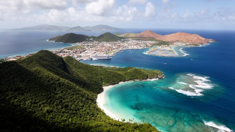
Nestled between the Atlantic Ocean and the Caribbean Sea, the U.S. Virgin Islands offer a spectacular cross-section of volcanic terrain, coral reefs, dry forests, and mangroves. Beyond the postcard, this small island territory contends with tectonic forces, resource constraints, tourism pressures, and climate threats. Understanding its geography means grasping the fragile balance between nature, development, and risk in one of the most distinctive archipelagos in the Caribbean.
A Pivotal Archipelago Between the Atlantic and the Caribbean Sea
The territory lies in the eastern portion of the Caribbean Sea, within the Leeward Islands, themselves part of the Lesser Antilles. It occupies the western part of the Virgin Islands archipelago, about forty miles east of Puerto Rico and immediately west and south of the British Virgin Islands. To the north, the ocean boundary approaches the vast Puerto Rico Trench, while to the southeast, the Anegada Passage serves as a maritime corridor connecting the Atlantic and the Caribbean.
This is the distance in miles that separates the archipelago from Miami, illustrating its relative isolation.
Composition of the Archipelago: Three Main Islands and a Galaxy of Cays
The territory consists of three main islands – St. Thomas, St. John, and St. Croix – along with Water Island and about fifty uninhabited or sparsely occupied islets and cays. Total land area is approximately 134 square miles, or just over 346 km², barely twice the size of Washington, D.C., surrounded by about 1,910 km² of marine areas.
The territory has a clear division between its islands. To the north, St. Thomas and St. John are close together and share the same insular platform near Puerto Rico. To the south, St. Croix is isolated 40 miles away, separated by the Virgin Islands Trough, a marine trench several thousand meters deep. This geographic separation is accompanied by marked differences in geology, climate, and ecology between the islands.
A symbolic geographic indicator illustrates the territory’s place within the broader United States: the easternmost point of all the United States, Point Udall, is located at the eastern tip of St. Croix, literally facing the sunrise over the Atlantic.
Island Topography: Volcanic Mountains and Coral Plateaus
The internal geography of the islands is dominated by relief. Truly flat land is rare and is concentrated in valleys, narrow coastal plains, and a few coral plateaus, particularly on St. Croix. The rest is a mosaic of hills, mountains, and steep slopes plunging into the sea.
A String of Peaks on St. Thomas and St. John
St. Thomas and St. John are primarily volcanic in origin. They are merely the emerged portions of a long submarine mountain range, formed by volcanism associated with the subduction of the North American Plate beneath the Caribbean Plate. The oldest rocks, especially visible on St. John, date back to the Cretaceous, between 120 and 100 million years ago, and tell a complex story of submarine volcanism, ash deposits, pillow lavas, volcanic turbidites, and successive folding.
On the island of St. Thomas, a central ridge of hills and crests structures the territory, branching out toward the bays. Since flat areas are very limited, urbanization adapts by clinging to slopes or concentrating in the rare coastal plains. The highest point, Crown Mountain (474 m), offers a panorama of Charlotte Amalie’s natural harbor, considered one of the finest in the Caribbean.
St. John, though smaller, is no less rugged. More than 80% of the island has slopes exceeding 30 degrees, with reliefs culminating at Bordeaux Mountain (389 m) and Camelberg Peak (about 1,190 feet). These steep slopes channel rainwater into sometimes violent torrents, intensify erosion, and complicate the traditional construction of roads, buildings, and utilities.
St. Croix, the Coral Exception
Conversely, St. Croix largely rests on an ancient volcanic basement overlain by sedimentary limestone and coral rocks. The island has a two-part profile: a mountainous massif in the northwest, culminating at Mount Eagle (332 m) and Blue Mountain (about 334 m), descending in slopes toward a broad coastal plain in the south; to the east, lower hills and an undulating landscape, a vestige of the island’s sugar plantation past, where more than half the land was once covered in sugarcane.
The island’s flat topography, historically favorable to agriculture and infrastructure, now exposes vast low-lying coastal areas to high risk of marine inundation and storm impacts.
A Tectonic Structure Under High Stress
The geographic setting is shaped by ongoing tectonics. The territory lies on the northern edge of the Caribbean Plate, at its contact with the North American Plate. Historically, the subduction of the latter beneath the Caribbean Plate produced the volcanoes that gave rise to the islands. Today, the contact is mainly expressed as strike-slip motion: the two plates slide laterally past each other at a rate of a few centimeters per year.
The scars of this history are visible in the east-west folds of Cretaceous formations, strike-slip faults that offset strata by several kilometers, and more recent granitic or tonalitic intrusions. On a regional scale, this dynamics explains the existence of the Puerto Rico Trench, over 9,000 meters deep, and the Virgin Islands Basin, exceeding 2,500 meters, which flank the archipelago.
Although the islands no longer host active volcanoes, their position on a plate margin results in a real earthquake risk, along with the potential for tsunamis. These hazards combine with those from hurricanes, making the local geography a prime area for studying natural risks.
A Jagged Coastline, Between Deep Bays and Barrier Reefs
With nearly 188 miles of coastline, the islands display almost every tropical coastal landscape: volcanic cliffs, white sand beaches, mangrove-lined lagoons, barrier reefs, sheltered coves, and deep channels.
Strategic Natural Harbors
St. Thomas and St. Croix possess two of the finest natural harbors in the Caribbean region. The port of Charlotte Amalie, long and deep, is set into the relief of St. Thomas and offers reliable anchorage for cruise ships, cargo vessels, and pleasure boats. Its location near the Anegada Passage, a major shipping route toward the Panama Canal, gives it a key role in regional commerce.
Length in feet of the channel protecting the Christiansted harbor complex, designed as a hurricane haven.
Beaches, Bays, and Reefs: The Postcard and Its Geographic Function
Names like Magens Bay (St. Thomas) or Trunk Bay (St. John) are known to beach lovers in the Caribbean. These sheltered bays owe their white sand to the coral reefs that surround them and supply fine calcareous sediments. The reefs create calm water zones, dampen swells, and allow the formation of long beaches and lagoons ideal for swimming, diving, or anchoring.
The islands are surrounded by fringing reefs, with St. Croix featuring an almost continuous reef system that forms a natural barrier. Offshore from Cane Bay, the underwater slope, called “The Wall,” plunges steeply into the depths of the Puerto Rico Trough, making it a renowned dive site.
These reef structures have a strategic geographic dimension: according to assessments, they provide approximately $47 million in annual benefits from flood protection by buffering storm waves and limiting coastal erosion.
A Tropical Climate Regulated by Trade Winds… but Exposed to Cyclones
Located around the 18th parallel north, the islands enjoy a tropical climate tempered by easterly trade winds. Temperatures vary little throughout the year, with an average range between winter and summer not exceeding 3°C.
Temperatures, Sunshine, and Humidity
The annual average hovers around 26 to 27°C, with winters around 25°C and summers near 28°C. In Charlotte Amalie, daily highs typically range around 30°C in winter and 32 to 33°C in summer; lows often remain above 22°C in winter and 25°C in summer. The sea remains swimmable year-round, with water temperatures between 26°C in late winter and 29°C in early fall.
Sunshine approaches 3,000 hours per year, and relative humidity, often between 74% and 81%, is moderated by the nearly constant wind. St. Croix, farther south, tends to be slightly warmer and drier; St. John, more wooded and hilly, may feel a bit cooler.
Rainy and Dry Seasons
Annual rainfall ranges, depending on location, from about 950 to 1,200 mm, but is very irregular. A distinct dry season runs from January to April, with a minimum in February-March, followed by a long wet season from May to December, peaking in precipitation from September to November. Within this wet period, a relative dip occurs in June-July.
This is the average annual precipitation in millimeters recorded around Christiansted on the island of St. Croix.
Hurricanes, Extremes, and Climate Change
The territory lies directly in the Atlantic “hurricane belt”. The cyclone season runs from June to November, with peak risk from August to October. Tropical storms and hurricanes can bring violent winds, torrential rains, and devastating storm surges, as demonstrated by major events such as Hugo, Marilyn, Irma, and Maria.
Increase in degrees Celsius of air and sea temperatures in the region since the mid-20th century.
Added to this is sea level rise: scenarios project a rise for the territory of between 0.19 and 0.58 m by 2100. Even though most of the emerged land is at a good elevation, low-lying coastal areas, urban waterfronts – especially in Charlotte Amalie – and port infrastructure are on the front line facing inundation, erosion, and salinization of coastal aquifers.
Some Comparative Climate Benchmarks
To gauge internal contrasts, some climate characteristics of the main islands can be summarized in a simplified table.
| Parameter | St. Thomas / St. John (north) | St. Croix (south) |
|---|---|---|
| Climate type (Köppen) | Tropical monsoon (Am) | Tropical savanna (Aw) |
| Average temperature (°C) | ≈ 27.1 | ≈ 27.2 |
| Annual rainfall | 1,000 – 1,200 mm | ≈ 940 – 1,100 mm |
| Surface water resources | Some streams, springs | Very limited, few streams |
| Hurricane exposure | High | High |
These differences remain modest, but they influence vegetation, land use, and certain forms of human settlement.
Remarkably Diverse Island Ecosystems
On a tiny territory, the diversity of natural environments is astonishing. The gradient of rainfall, the variety of geological substrates, and topographical fragmentation explain the coexistence of moist forests, dry forests, shrub savannas, mangroves, and coral reefs.
Moist Forests, Dry Forests, and Xeric Scrub
The islands belong to the major terrestrial ecoregions of the Leeward Islands moist forests and the Leeward Islands xeric scrub. At least four main types of terrestrial vegetation can be distinguished: moist forests, dry forests, open woodlands, and mangroves.
The higher, better-watered areas harbor denser, cooler forests, sometimes referred to as “rainforests” on St. Croix. Conversely, leeward areas, low limestone hills, and drier slopes support thorny thickets, xeric scrub, and shrub savannas. This vegetation mosaic plays an essential role in hydrological regulation and soil stabilization.
Mangroves, Seagrass Beds, and Dunes: The Coastal Protection Belt
In the coastal zone, mangroves form a living boundary between land and sea. They serve as natural breakwaters, dampen wave energy, reduce erosion, and filter sediments before they reach the reefs. They also serve as critical nurseries for fish, crustaceans, and certain birds. The largest mangrove stand in the territory is near Salt River Bay on St. Croix—a site paradoxically adjacent to a major municipal landfill, posing pollution risks.
Seagrass beds, composed of phanerogams like turtlegrass, manatee grass, and shoal grass, play a crucial ecological role. They trap sediments, stabilize the seafloor, and serve as a food source for many species, including sea turtles. In synergy with coral reefs, they attenuate wave energy, thus contributing to protecting coastlines and beaches from erosion.
Coastal dunes, finally, stand as natural ramparts against storms. Held in place by vegetation adapted to salt and wind, they limit marine incursions inland. When these dunes are truncated or urbanized, the vulnerability of backshore areas increases significantly.
Coral Reefs: A Living Architecture at the Archipelago Scale
The territory’s waters harbor approximately 200 km² of coral reefs and associated hard bottom. Benthic maps indicate that 61% of a 485 km² study area is occupied by coral formations or hard substrates colonized by corals, 33% by seagrass beds, and 4% by unvegetated sandy or rocky bottoms.
The coral reefs of the U.S. Virgin Islands exhibit a wide variety of forms. These include fringing reefs directly attached to the shoreline, complex barrier reefs protecting the east and south coasts of St. Croix, patch reefs, spur-and-groove structures at the edge of the insular platform, and shelf-edge reefs located between 40 and 60 meters deep offshore from St. Thomas and St. John.
These reefs host more than 580 species of reef fish, over 40 species of scleractinian reef-building corals, three species of fire coral (Millepora), four species of sea turtles, and a multitude of invertebrates. They support artisanal fisheries, dive tourism, local cuisine, and contribute to the cultural identity of the archipelago, from coral stone buildings to seafood-based recipes.
To summarize the richness of these habitats, we can compare their proportions in the best-mapped area:
| Type of marine habitat | Estimated share of mapped area |
|---|---|
| Coral reefs and hard substrate corals | ≈ 61% |
| Seagrass beds (marine phanerogams) | ≈ 33% |
| Poorly colonized sedimentary or rocky bottoms | ≈ 4% |
| Other/undetermined | ≈ 2% |
These figures measure the central place of reef and seagrass ecosystems in the local underwater geography.
Human Settlement Concentrated on Coasts and Plains
While physical geography imposes its constraints, the distribution of population and infrastructure has largely amplified pressure on coastal zones and the few plains.
Island Demographics and High Densities
On a land area of about 350 km², population density exceeds 230 inhabitants per km², with much higher peaks in the urban basins of Charlotte Amalie (St. Thomas), Christiansted and Frederiksted (St. Croix), and the Cruz Bay area (St. John). The territory is highly urbanized: more than 95% of residents live in environments classified as urban.
Steep slopes, the low availability of arable land (about 11.5% agricultural area, of which less than 3% is arable), and the scarcity of plains explain this concentration along the coast and in the most accessible valleys. Tourist infrastructure—hotels, marinas, shops—has particularly developed in the low-lying coastal fringe, precisely where risks of inundation and erosion are highest.
Networks and Infrastructure in a Constrained Landscape
The organization of the territory is also legible in its networks. About 1,230 to 1,240 miles of roads crisscross the islands, including roughly 750 miles of public roads, the rest being private roads often unpaved. Most public roads are two-lane, narrow, without shoulders, and follow winding alignments with steep grades, a direct consequence of the rugged topography. Driving on the left, a unique historical legacy, combined with a majority of left-hand-drive vehicles, reinforces the peculiarity of this road network.
A study reveals that approximately 89% of street lengths lack sidewalks in the islands concerned.
On the maritime and air transport side, two international airports—on St. Thomas and St. Croix—serve the territory, while St. John and Water Island are accessible only by ferry or private vessel. A constellation of ports, marinas, and ferry terminals dot the bays and channels, making boats an essential vector of cohesion between the islands.
Coastal Occupation and Vulnerabilities
Historically, the low-lying parts of the islands, especially on St. Croix, were shaped by plantations and agricultural infrastructure; today, they are largely taken over by urbanization, industrial facilities—including oil and port installations—or tourism developments. On St. Thomas, nearly the entire waterfront of Charlotte Amalie and its nearby bays is occupied by port, commercial, and residential functions.
The territory’s configuration exposes it to multiple risks (sea level rise, storm surge, flooding, soil instability). Many older buildings do not meet setback, elevation, or drainage standards, thereby increasing the exposure of populations and assets.
Water Resources, Soils, and Environment: A Territory Under Pressure
The geographic nature of the islands—small, mountainous, without major permanent rivers—makes freshwater resources particularly vulnerable. The combination of thin soils and steep slopes favors rapid runoff and erosion, at the expense of infiltration.
Freshwater Scarcity and Dependence on Infrastructure
The islands have no major rivers; a few streams and springs, especially on St. John, locally supply ecosystems and some domestic uses, but most drinking water needs are met by rainwater collection (individual cisterns) and seawater desalination. Water supply and sanitation networks are also very uneven across areas, leading to widespread reliance on septic tanks.
This is the number of million gallons of wastewater conveyed daily by the sewer system to treatment plants.
Erosion, Sediments, and Coastal Pollution
Deforested slopes, poorly drained roads, and ill-adapted construction amplify erosion and sediment production, which by far represent the primary pollutant of coastal waters by volume. Carried into bays by heavy rains, these sediments cloud the water, smother corals, settle on seagrass beds, and degrade marine habitats. Extreme rainfall events, expected to become more frequent with climate change, reinforce this phenomenon.
Some sites symbolize the tension between natural geography and development: the large mangrove of Salt River Bay, for example, lies immediately adjacent to a major waste landfill. Yet the territory produces nearly three times the U.S. national average of solid waste per capita, placing heavy pressure on coastal landfills vulnerable to flooding and leachate.
Example of geographic tension
In several bays, the combination of wastewater discharges, polluted runoff, and heavy boating traffic has made local swimming and fishing sometimes risky, both for human health and for ecosystems.
Climate Change: A Total Geographic Challenge
The physical characteristics of the territory—small size, insularity, high coastalization, dependence on imports—make it a zone particularly sensitive to the impacts of climate change.
Droughts, Extreme Rains, and Water Resources
Since 1960, the frequency of droughts has increased markedly, as has that of flooding since the mid-1990s. Models project an average decrease in annual precipitation of around 6 to 12% by mid-century, possibly up to 25% by 2080, but with more frequent and intense extreme rainfall events.
For a territory without large renewable aquifers or major natural reservoirs, climate change increases the risk of drinking water shortages, promotes salinization of coastal aquifers through seawater intrusion, and worsens soil erosion during heavy rains. Additionally, the natural acidity of runoff, combined with more intense precipitation, can accelerate rock weathering and slope instability.
Warmer Sea, Reefs in Danger
A rise of just 1 to 2°C above the normal maximum sea temperature is enough to trigger mass coral bleaching. The territory has experienced particularly severe episodes, notably in 2023 and 2024, when water temperature reached about 33°C. These marine heatwaves, combined with ocean acidification, weaken reefs already stressed by diseases (Stony Coral Tissue Loss Disease, white band, white pox, etc.), invasive species like the Indo-Pacific lionfish, anchoring damage, and land-based pollution.
Elkhorn coral has experienced a 90% decline in its populations in some areas over the past forty years.
Sea Level Rise and a Coastline to Reinvent
Projections of sea level rise—from 0.6 to 1.9 feet by 2100—may seem modest relative to the height of the terrain, but they translate into a disproportionate increase in risks for low-lying areas already prone to flooding, erosion, and inundation. The urban waterfronts of Charlotte Amalie, Christiansted, Frederiksted, port, energy, and tourism infrastructure, as well as coastal villages, are directly threatened.
The configuration of narrow bays surrounded by slopes sometimes promotes a funnel effect for swells and storm surges, exacerbating flooding. Moreover, about half of the power plants are already located in flood-prone areas, reinforcing the vulnerability of the energy system, which is heavily dependent on imported petroleum products through exposed port terminals.
A Managed Geography: Parks, Planning, and Adaptation
Faced with these challenges, the territory’s human geography is gradually reorganizing around ecosystem protection, adaptation to risks, and modernization of infrastructure.
A Network of National Parks and Protected Areas
The U.S. National Park Service manages over half of St. John, nearly all of Hassel Island in St. Thomas harbor, and extensive reef areas. Protected sites include Virgin Islands National Park, Virgin Islands Coral Reef National Monument, Buck Island Reef National Monument, Christiansted National Historic Site, and Salt River Bay National Historical Park and Ecological Preserve.
On the marine side, six protected areas are divided between local and federal management. On St. Croix, the St. Croix East End Marine Park (STXEEMP), 17 miles long, is zoned into recreation, no-take, sea turtle reserve, and open areas. On St. Thomas, the St. Thomas East End Reserve (STEER) protects a mosaic of mangroves, seagrass beds, and reefs. These perimeters aim to reconcile fishing, tourism, biodiversity protection, and coastal resilience.
Coral reef restoration uses proactive techniques (nurseries, microfragments, assisted sexual reproduction) and relies on structured plans. It involves a diverse network of stakeholders, including local agencies, NGOs, universities, and federal programs such as those of NOAA.
Planning Tools and Nature-Based Solutions
Several guiding documents frame territorial and environmental planning: draft comprehensive land and water use plans, development law, a draft biodiversity law, a “Green Paper” on climate change, and ecosystem-based adaptation workshops. The updated Environmental Protection Handbook sets standards for stormwater management, a critical condition in a landscape prone to violent runoff.
The trend is toward integrating “nature-based solutions” (ecosystem-based adaptation): mangrove restoration to reduce erosion and filter pollutants, dune reconstruction, seagrass conservation, land acquisition to protect ecological corridors and create new parks. The goal is twofold: strengthen ecological resilience while offering social and economic co-benefits (sustainable fishing, nature tourism, green job training).
GIS (Geographic Information System) mapping initiatives help identify areas most vulnerable to natural hazards such as sea level rise, landslides, or flooding. This spatial analysis is essential to guide future land-use planning choices and the strategic relocation of critical infrastructure, contributing to better risk management.
Infrastructure, Energy, and Transportation: Adapting Networks to Geography
Federal funding, particularly through infrastructure investment laws, is being mobilized to modernize drinking water, sanitation, and road networks, as well as to strengthen the resilience of ports, airports, and power plants. Post-hurricane reconstruction has highlighted the importance of buried power lines, drainage systems suited to extreme events, and upgraded building codes in coastal plains.
The energy system, heavily dependent on fuel imports, becomes a geographic issue in its own right: oil terminals and power plants are often in flood zones, and overhead lines are fragile in cyclonic winds. Plans to reduce oil consumption, develop renewable energy (solar, wind on exposed ridges), and secure maritime entry points are thus central to territorial planning.
In the transportation sector, a master plan for the 2050 horizon seeks to balance the needs of residents, tourists, and temporary workers by adapting roads, public transit (VITRAN, ferries), and pedestrian and bicycle paths to a demanding terrain and growing risks.
A Geography in Constant Motion
At the intersection of tectonic plates, ocean currents, trade winds, and shipping lanes, the territory is characterized by an extremely dynamic geography. Volcanic mountains, coral plains, mangroves, reefs, and coastal towns are arranged in an unstable balance, reshaped by every hurricane, every drought, and every development choice.
This territory concentrates major challenges such as climate change and biodiversity loss. The solutions being implemented, such as strengthening protected areas and restoring reefs, aim to make nature an essential partner for the survival of the islands, beyond its mere decorative or utilitarian value.
In this context, the geography of the U.S. Virgin Islands is not a fixed given, but an ongoing story written at the interface of rock, water, air, and the human societies that have settled there. Understanding its relief, climates, ecosystems, and constraints means being able to anticipate future transformations of an archipelago that, despite its small size, occupies a disproportionate place in the living laboratory of tropical islands confronting the upheavals of the 21st century.
Disclaimer: The information provided on this website is for informational purposes only and does not constitute financial, legal, or professional advice. We encourage you to consult qualified experts before making any investment, real estate, or expatriation decisions. Although we strive to maintain up-to-date and accurate information, we do not guarantee the completeness, accuracy, or timeliness of the proposed content. As investment and expatriation involve risks, we disclaim any liability for potential losses or damages arising from the use of this site. Your use of this site confirms your acceptance of these terms and your understanding of the associated risks.

Cyril Jarnias is an independent expert in international wealth management with over 20 years of experience. As an expatriate himself, he is dedicated to helping individuals and business leaders build, protect, and pass on their wealth with complete peace of mind.
On his website, cyriljarnias.com, he shares his expertise on international real estate, offshore company formation, and expatriation.
Thanks to his expertise, he offers sound advice to optimize his clients' wealth management. Cyril Jarnias is also recognized for his appearances in many prestigious media outlets such as BFM Business, les Français de l’étranger, Le Figaro, Les Echos, and Mieux vivre votre argent, where he shares his knowledge and know-how in wealth management.